You are here: Home > Network List > XA95 - Missouri to Massachusetts Transect Stations List
> Station MM10 Bellville, Ohio > Earthquake Result Viewer
MM10 Bellville, Ohio - Earthquake Result Viewer
| Earthquake location: |
Northern Peru |
| Earthquake latitude/longitude: |
-3.9/-77.0 |
| Earthquake time(UTC): |
1995/05/02 (122) 06:06:05 GMT |
| Earthquake Depth: |
103 km |
| Earthquake Magnitude: |
6.5 MB, 6.7 UNKNOWN, 6.6 MW |
| Earthquake Catalog/Contributor: |
WHDF/NEIC |
|
| Network: |
XA Missouri to Massachusetts Transect |
| Station: |
MM10 Bellville, Ohio |
| Lat/Lon: |
40.61 N/82.30 W |
| Elevation: |
346 m |
|
| Distance: |
44.5 deg |
| Az: |
354.196 deg |
| Baz: |
172.383 deg |
| Ray Param: |
0.07151565 |
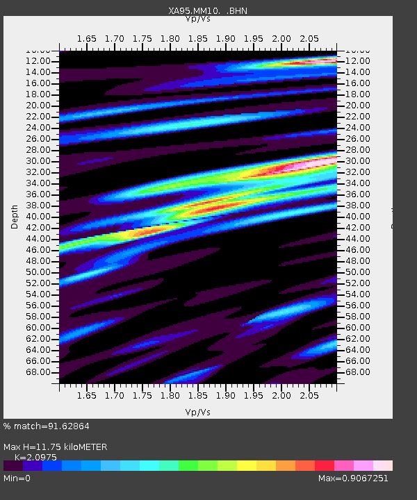
| Estimated Moho Depth: |
11.75 km |
| Estimated Crust Vp/Vs: |
2.10 |
| Assumed Crust Vp: |
6.498 km/s |
| Estimated Crust Vs: |
3.098 km/s |
| Estimated Crust Poisson's Ratio: |
0.35 |
|
| Radial Match: |
91.62864 % |
| Radial Bump: |
400 |
| Transverse Match: |
83.54537 % |
| Transverse Bump: |
400 |
| SOD ConfigId: |
6273 |
| Insert Time: |
2010-02-26 17:50:59.997 +0000 |
| GWidth: |
2.5 |
| Max Bumps: |
400 |
| Tol: |
0.001 |
|
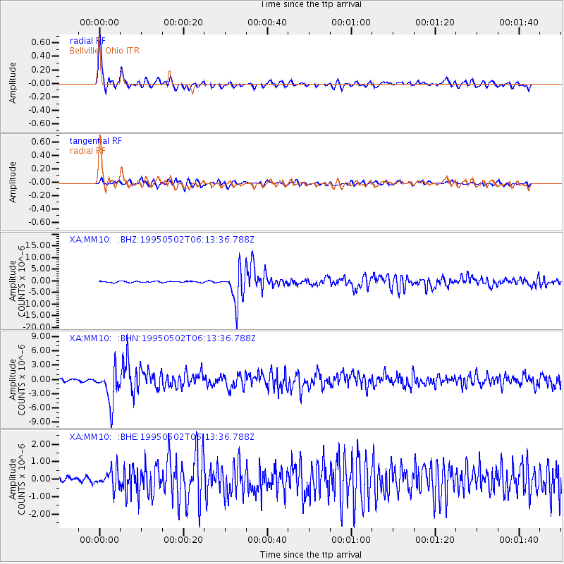
Signal To Noise
| Channel | StoN | STA | LTA |
| XA:MM10: :BHN:19950502T06:13:36.788Z | 15.498307 | 3.658156E-6 | 2.3603585E-7 |
| XA:MM10: :BHE:19950502T06:13:36.788Z | 3.1099238 | 5.0654296E-7 | 1.6287953E-7 |
| XA:MM10: :BHZ:19950502T06:13:36.788Z | 29.851828 | 7.297897E-6 | 2.444707E-7 |
| Arrivals |
| Ps | 2.1 SECOND |
| PpPs | 5.3 SECOND |
| PsPs/PpSs | 7.4 SECOND |


