You are here: Home > Network List > XA95 - Missouri to Massachusetts Transect Stations List
> Station MM10 Bellville, Ohio > Earthquake Result Viewer
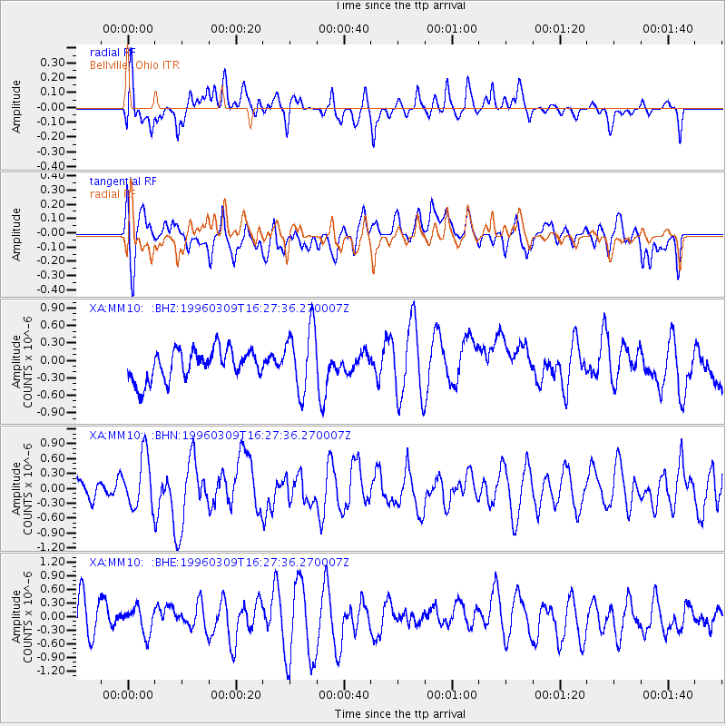
MM10 Bellville, Ohio - Earthquake Result Viewer
*The percent match for this event was below the threshold and hence no stack was calculated.
| Earthquake location: |
East Of Kuril Islands |
| Earthquake latitude/longitude: |
43.4/148.0 |
| Earthquake time(UTC): |
1996/03/09 (069) 16:15:36 GMT |
| Earthquake Depth: |
33 km |
| Earthquake Magnitude: |
5.6 MB, 5.9 MS, 6.1 UNKNOWN, 5.5 MS |
| Earthquake Catalog/Contributor: |
WHDF/NEIC |
|
| Network: |
XA Missouri to Massachusetts Transect |
| Station: |
MM10 Bellville, Ohio |
| Lat/Lon: |
40.61 N/82.30 W |
| Elevation: |
346 m |
|
| Distance: |
84.8 deg |
| Az: |
36.029 deg |
| Baz: |
325.74 deg |
| Ray Param: |
$rayparam |
*The percent match for this event was below the threshold and hence was not used in the summary stack. |
|
| Radial Match: |
38.60687 % |
| Radial Bump: |
400 |
| Transverse Match: |
52.5455 % |
| Transverse Bump: |
400 |
| SOD ConfigId: |
4480 |
| Insert Time: |
2010-02-26 17:51:07.870 +0000 |
| GWidth: |
2.5 |
| Max Bumps: |
400 |
| Tol: |
0.001 |
|
Signal To Noise
| Channel | StoN | STA | LTA |
| XA:MM10: :BHN:19960309T16:27:36.270007Z | 2.4590137 | 5.365488E-7 | 2.1819673E-7 |
| XA:MM10: :BHE:19960309T16:27:36.270007Z | 0.6388382 | 2.9383818E-7 | 4.5995716E-7 |
| XA:MM10: :BHZ:19960309T16:27:36.270007Z | 2.1659946 | 5.6429207E-7 | 2.605233E-7 |
| Arrivals |
| Ps | |
| PpPs | |
| PsPs/PpSs | |


