You are here: Home > Network List > XA95 - Missouri to Massachusetts Transect Stations List
> Station MM10 Bellville, Ohio > Earthquake Result Viewer
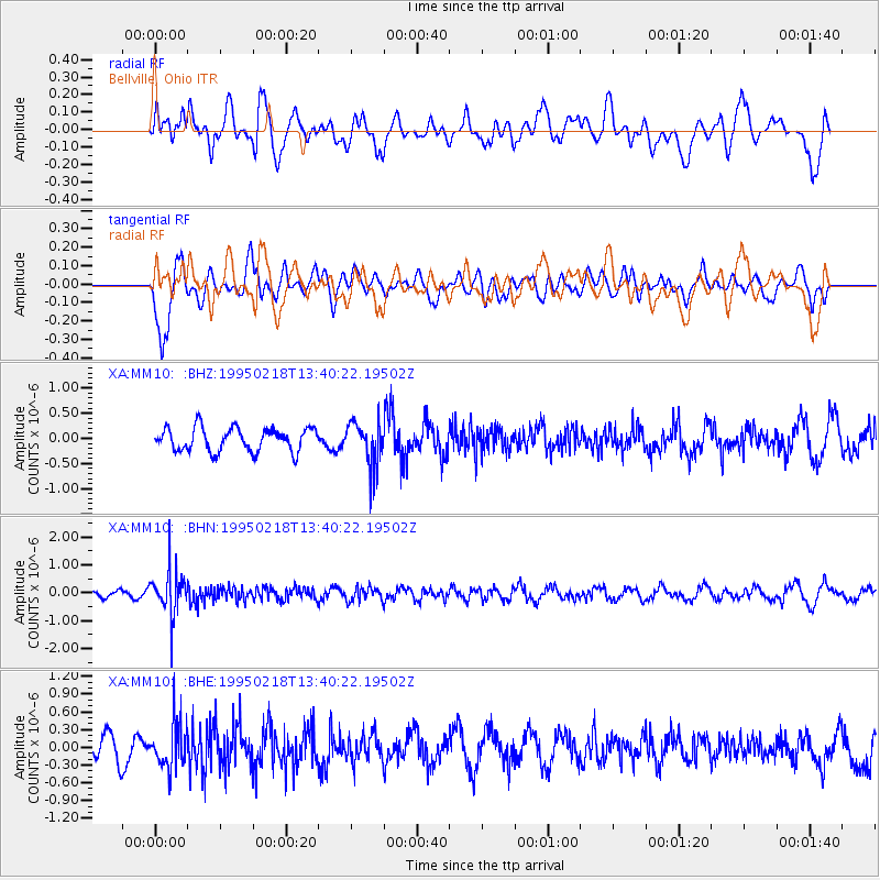
MM10 Bellville, Ohio - Earthquake Result Viewer
*The percent match for this event was below the threshold and hence no stack was calculated.
| Earthquake location: |
Sea Of Okhotsk |
| Earthquake latitude/longitude: |
46.7/145.9 |
| Earthquake time(UTC): |
1995/02/18 (049) 13:29:06 GMT |
| Earthquake Depth: |
355 km |
| Earthquake Magnitude: |
5.6 MB, 5.7 UNKNOWN, 5.5 MW |
| Earthquake Catalog/Contributor: |
WHDF/NEIC |
|
| Network: |
XA Missouri to Massachusetts Transect |
| Station: |
MM10 Bellville, Ohio |
| Lat/Lon: |
40.61 N/82.30 W |
| Elevation: |
346 m |
|
| Distance: |
83.1 deg |
| Az: |
34.866 deg |
| Baz: |
328.859 deg |
| Ray Param: |
$rayparam |
*The percent match for this event was below the threshold and hence was not used in the summary stack. |
|
| Radial Match: |
54.370564 % |
| Radial Bump: |
400 |
| Transverse Match: |
67.36186 % |
| Transverse Bump: |
400 |
| SOD ConfigId: |
4480 |
| Insert Time: |
2010-02-26 17:51:11.334 +0000 |
| GWidth: |
2.5 |
| Max Bumps: |
400 |
| Tol: |
0.001 |
|
Signal To Noise
| Channel | StoN | STA | LTA |
| XA:MM10: :BHN:19950218T13:40:22.19502Z | 6.5550675 | 8.135246E-7 | 1.2410621E-7 |
| XA:MM10: :BHE:19950218T13:40:22.19502Z | 1.3004718 | 3.8654989E-7 | 2.9723822E-7 |
| XA:MM10: :BHZ:19950218T13:40:22.19502Z | 1.9036089 | 4.415227E-7 | 2.3193982E-7 |
| Arrivals |
| Ps | |
| PpPs | |
| PsPs/PpSs | |


