You are here: Home > Network List > XA95 - Missouri to Massachusetts Transect Stations List
> Station MM10 Bellville, Ohio > Earthquake Result Viewer
MM10 Bellville, Ohio - Earthquake Result Viewer
*The percent match for this event was below the threshold and hence no stack was calculated.
| Earthquake location: |
Kuril Islands |
| Earthquake latitude/longitude: |
44.1/148.1 |
| Earthquake time(UTC): |
1995/04/28 (118) 17:08:43 GMT |
| Earthquake Depth: |
33 km |
| Earthquake Magnitude: |
6.2 MB, 6.2 MS |
| Earthquake Catalog/Contributor: |
WHDF/NEIC |
|
| Network: |
XA Missouri to Massachusetts Transect |
| Station: |
MM10 Bellville, Ohio |
| Lat/Lon: |
40.61 N/82.30 W |
| Elevation: |
346 m |
|
| Distance: |
84.3 deg |
| Az: |
36.138 deg |
| Baz: |
326.067 deg |
| Ray Param: |
$rayparam |
*The percent match for this event was below the threshold and hence was not used in the summary stack. |
|
| Radial Match: |
97.14845 % |
| Radial Bump: |
268 |
| Transverse Match: |
77.49497 % |
| Transverse Bump: |
400 |
| SOD ConfigId: |
4480 |
| Insert Time: |
2010-02-26 17:51:13.628 +0000 |
| GWidth: |
2.5 |
| Max Bumps: |
400 |
| Tol: |
0.001 |
|
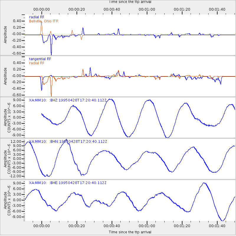
Signal To Noise
| Channel | StoN | STA | LTA |
| XA:MM10: :BHN:19950428T17:20:40.112Z | 1.7232941 | 1.200795E-5 | 6.9680214E-6 |
| XA:MM10: :BHE:19950428T17:20:40.112Z | 0.49518248 | 2.0318403E-6 | 4.1032154E-6 |
| XA:MM10: :BHZ:19950428T17:20:40.112Z | 1.638737 | 5.139319E-6 | 3.1361465E-6 |
| Arrivals |
| Ps | |
| PpPs | |
| PsPs/PpSs | |


