You are here: Home > Network List > XA95 - Missouri to Massachusetts Transect Stations List
> Station MM11 Columbus, Ohio > Earthquake Result Viewer
MM11 Columbus, Ohio - Earthquake Result Viewer
| Earthquake location: |
Kuril Islands |
| Earthquake latitude/longitude: |
44.6/149.4 |
| Earthquake time(UTC): |
1995/12/03 (337) 18:01:08 GMT |
| Earthquake Depth: |
33 km |
| Earthquake Magnitude: |
6.6 MB, 8.0 MS |
| Earthquake Catalog/Contributor: |
WHDF/NEIC |
|
| Network: |
XA Missouri to Massachusetts Transect |
| Station: |
MM11 Columbus, Ohio |
| Lat/Lon: |
40.22 N/83.19 W |
| Elevation: |
283 m |
|
| Distance: |
83.3 deg |
| Az: |
37.752 deg |
| Baz: |
325.143 deg |
| Ray Param: |
0.046263874 |
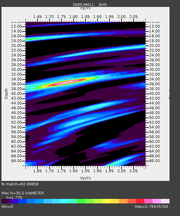
| Estimated Moho Depth: |
35.0 km |
| Estimated Crust Vp/Vs: |
1.77 |
| Assumed Crust Vp: |
6.498 km/s |
| Estimated Crust Vs: |
3.661 km/s |
| Estimated Crust Poisson's Ratio: |
0.27 |
|
| Radial Match: |
92.88658 % |
| Radial Bump: |
253 |
| Transverse Match: |
88.96359 % |
| Transverse Bump: |
400 |
| SOD ConfigId: |
6273 |
| Insert Time: |
2010-02-26 17:51:22.651 +0000 |
| GWidth: |
2.5 |
| Max Bumps: |
400 |
| Tol: |
0.001 |
|

Signal To Noise
| Channel | StoN | STA | LTA |
| XA:MM11: :BHN:19951203T18:13:00.593018Z | 2.2321458 | 1.0674419E-6 | 4.7821334E-7 |
| XA:MM11: :BHE:19951203T18:13:00.593018Z | 2.155008 | 1.2105208E-6 | 5.6172445E-7 |
| XA:MM11: :BHZ:19951203T18:13:00.593018Z | 3.2531047 | 2.0199784E-6 | 6.2093864E-7 |
| Arrivals |
| Ps | 4.3 SECOND |
| PpPs | 15 SECOND |
| PsPs/PpSs | 19 SECOND |


