
Station XA MM11 - Columbus, Ohio
Network: XA95 - Missouri to Massachusetts Transect
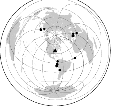
Nearby stations (2 deg radius)
| Station | Name | (Lat, Lon) | Start / End | Elevation |
| MM11 | Columbus, Ohio | (40.22, -83.19) | 1995-02-28 / 1996-04-10 | 283 m |
| Crust2 Type: | D9,Platform 1 km seds. |
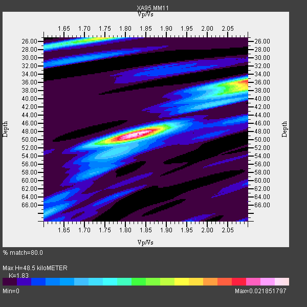
| Thickness Estimate: | 48 km |
| Thickness StdDev: | 7.1 km |
| Vp/Vs Estimate: | 1.83 |
| Vp/Vs StdDev: | 0.11 |
| Vs Estimate: | 3.551 km/s |
| Poisson's Ratio: | 0.29 |
| Peak Value: | 0.02 |
| Assumed Vp: | 6.498 km/s |
| Ps Weight: | 0.33333334 |
| PpPs Weight: | 0.33333334 |
| PsPs Weight: | 0.33333328 |
| Residual Complexity: | 0.623 |
| Nearby stations H: | +- |
| (2.0 deg) Vp/Vs: | +- |
13 with match > 90% ( 28.26087 %) and 16 with match > 80% ( 34.782608 %) out of 46.
Download stack as xyz text file.
Azimuth Distribution of Events:
Prior Results for this Station
| Study | Thickness | Vp/Vs | Vp | Vs | Poissons Ratio | Extra |
| EARS | 48 km | 1.83 | 6.498 km/s | 3.551 km/s | 0.29 | |
| Crust2.0 | 41 km | 1.77 | 6.498 km/s | 3.666 km/s | 0.27 | D9,Platform 1 km seds. |
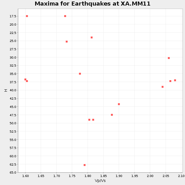
| Global Maxima | 48 km | 1.83 | 6.498 km/s | 3.551 km/s | 0.29 | amp=0.021851797 |
| Local Maxima 1 | 36 km | 2.10 | 6.498 km/s | 3.098 km/s | 0.35 | amp=0.017862892 |
| Local Maxima 2 | 25 km | 1.75 | 6.498 km/s | 3.718 km/s | 0.26 | amp=0.014549963 |
| Local Maxima 3 | 37 km | 2.10 | 6.498 km/s | 3.098 km/s | 0.35 | amp=0.010240104 |
| Local Maxima 4 | 50 km | 1.83 | 6.498 km/s | 3.56 km/s | 0.29 | amp=0.0056230626 |
| Predicted Arrivals for vertical incidence (zero ray parameter) | |
| Ps | 6.20 SECOND |
| PpPs | 21.12 SECOND |
| PsPs/PpSs | 27.32 SECOND |
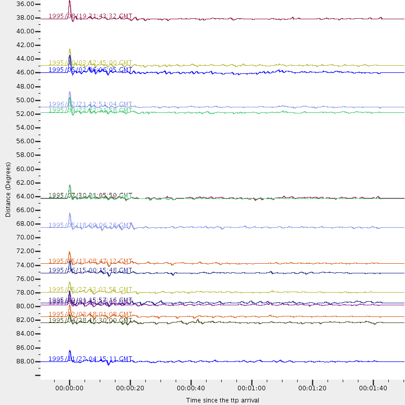
Events Processed for this Station
Download zip of receiver functions as SAC
Plot maxima for each earthquake.
Events Used in the Stack
(16 events)| Radial Match | Distance | Baz | FERegion | Time | Lat/Lon | Depth | Magnitude |
| 98.35098 | 64.4 deg | 166.867 deg | Near Coast Of Northern Chile | 1995/07/30 05:11:23 GMT | (-23.4, -70.3) | 47 km | 6.6 MB, 7.3 MS, 7.2 UNKNOWN, 8.1 MW |
| 96.96144 | 79.4 deg | 333.456 deg | Sakhalin, Russia | 1995/05/27 13:03:55 GMT | (52.6, 142.8) | 33 km | 6.6 MB, 7.6 MS, 7.0 UNKNOWN, 7.0 MW |
| 96.8492 | 35.6 deg | 167.092 deg | Colombia | 1995/08/19 21:43:32 GMT | (5.1, -75.7) | 125 km | 6.1 MB, 6.6 UNKNOWN, 6.5 MW |
| 96.834145 | 76.3 deg | 51.221 deg | Greece | 1995/06/15 00:15:48 GMT | (38.4, 22.3) | 14 km | 6.0 MB, 6.5 MS, 6.5 UNKNOWN, 5.7 ML |
| 96.57201 | 49.7 deg | 175.309 deg | Off Coast Of Northern Peru | 1996/02/21 12:51:04 GMT | (-9.6, -79.6) | 33 km | 5.8 MB, 6.6 MS, 7.5 UNKNOWN, 7.3 MW |
| 94.88919 | 81.4 deg | 324.912 deg | Kuril Islands | 1995/04/17 23:28:08 GMT | (45.9, 151.3) | 34 km | 6.1 MB, 6.3 MS, 6.2 UNKNOWN, 6.8 MW |
| 94.15996 | 69.0 deg | 110.196 deg | Central Mid-Atlantic Ridge | 1995/05/18 00:06:26 GMT | (-0.9, -22.0) | 10 km | 6.2 MB, 6.1 MS, 6.8 UNKNOWN, 6.7 MW |
| 93.1045 | 44.2 deg | 171.061 deg | Northern Peru | 1995/05/02 06:06:05 GMT | (-3.9, -77.0) | 103 km | 6.5 MB, 6.7 UNKNOWN, 6.6 MW |
| 92.88658 | 83.3 deg | 325.143 deg | Kuril Islands | 1995/12/03 18:01:08 GMT | (44.6, 149.4) | 33 km | 6.6 MB, 8.0 MS |
| 92.1079 | 43.1 deg | 172.244 deg | Peru-Ecuador Border Region | 1995/10/03 12:45:00 GMT | (-2.8, -77.9) | 33 km | 6.0 MB, 6.1 MS, 5.9 UNKNOWN, 6.4 MW |
| 91.81758 | 50.7 deg | 174.278 deg | Near Coast Of Peru | 1995/09/23 22:31:58 GMT | (-10.5, -78.7) | 73 km | 5.9 MB, 6.5 UNKNOWN, 6.4 MW |
| 90.4015 | 90.4 deg | 50.753 deg | Egypt | 1995/11/22 04:15:11 GMT | (28.8, 34.9) | 10 km | 6.2 MB, 7.3 MS, 7.2 UNKNOWN, 6.2 ML |
| 90.28423 | 74.8 deg | 50.152 deg | Greece | 1995/05/13 08:47:12 GMT | (40.1, 21.7) | 13 km | 6.2 MB, 6.5 MS, 6.6 UNKNOWN, 6.5 MD |
| 89.01128 | 64.3 deg | 167.135 deg | Near Coast Of Northern Chile | 1995/07/30 21:05:50 GMT | (-23.3, -70.6) | 33 km | 5.6 MB, 5.6 MS, 5.4 UNKNOWN, 6.1 MW |
| 87.13607 | 81.0 deg | 47.152 deg | Turkey | 1995/10/01 15:57:16 GMT | (38.1, 30.2) | 33 km | 5.7 MB, 6.1 MS, 6.3 UNKNOWN, 6.0 MW |
| 84.3636 | 84.2 deg | 325.59 deg | Kuril Islands | 1995/04/28 16:30:00 GMT | (44.1, 148.1) | 29 km | 6.6 MB, 6.9 MS, 7.0 UNKNOWN, 6.8 MW |
Losers
(30 events)| Radial Match | Distance | Baz | FERegion | Time | Lat/Lon | Depth | Magnitude | Reason |
| 92.23382 | 98.2 deg | 6.073 deg | Southern Xinjiang, China | 1995/08/17 00:59:57 GMT | (41.6, 88.8) | 0.0 km | 6.0 MB | |
| 89.21476 | 88.1 deg | 356.12 deg | Lake Baykal Region, Russia | 1995/06/29 23:02:31 GMT | (51.9, 103.1) | 33 km | 5.6 MB, 5.5 MS, 5.7 UNKNOWN | |
| 78.26526 | 82.4 deg | 325.308 deg | Kuril Islands | 1996/02/07 21:36:45 GMT | (45.3, 149.9) | 33 km | 6.3 MB, 7.0 MS, 7.2 UNKNOWN, 7.1 MW | |
| 76.89769 | 73.2 deg | 325.363 deg | Off East Coast Of Kamchatka | 1995/04/01 05:50:20 GMT | (52.3, 159.1) | 47 km | 5.9 MB, 5.6 MS, 5.3 UNKNOWN, 6.0 MW | |
| 75.65556 | 57.1 deg | 313.04 deg | Fox Islands, Aleutian Islands | 1996/03/30 13:05:17 GMT | (52.2, -168.7) | 33 km | 5.9 MB, 6.2 MS, 6.3 UNKNOWN, 6.1 ML | |
| 74.675446 | 89.9 deg | 325.906 deg | Off East Coast Of Honshu, Japan | 1995/07/08 05:42:56 GMT | (39.6, 143.4) | 40 km | 5.7 MB, 5.5 MS, 5.2 UNKNOWN, 6.0 MW | |
| 72.65638 | 78.2 deg | 199.051 deg | Southern East Pacific Rise | 1995/10/12 23:41:45 GMT | (-35.4, -106.2) | 10 km | 5.5 MB, 5.3 MS, 5.9 UNKNOWN | |
| 71.13238 | 64.1 deg | 167.11 deg | Near Coast Of Northern Chile | 1995/08/03 01:57:21 GMT | (-23.1, -70.6) | 33 km | 5.4 MB, 5.9 MS, 5.7 UNKNOWN, 6.3 MW | |
| 69.67232 | 69.4 deg | 166.84 deg | Chile-Argentina Border Region | 1995/08/03 08:18:53 GMT | (-28.3, -69.2) | 104 km | 5.9 MB, 5.8 UNKNOWN, 5.9 MW | |
| 67.681656 | 84.3 deg | 325.568 deg | Kuril Islands | 1995/04/28 17:59:24 GMT | (44.0, 148.1) | 33 km | 4.8 MB, 6.0 MS | |
| 64.89303 | 64.1 deg | 167.09 deg | Near Coast Of Northern Chile | 1995/08/02 00:14:09 GMT | (-23.2, -70.6) | 33 km | 5.4 MB, 5.5 MS, 5.3 UNKNOWN | |
| 63.181873 | 83.3 deg | 324.609 deg | Kuril Islands | 1995/12/10 22:48:08 GMT | (44.2, 150.0) | 33 km | 5.5 MB, 6.2 MS | |
| 62.374798 | 41.3 deg | 173.233 deg | Ecuador | 1996/03/28 23:03:49 GMT | (-1.0, -78.7) | 33 km | 5.8 MB, 5.2 MS, 5.9 UNKNOWN, 5.1 MS | |
| 62.290897 | 74.3 deg | 170.068 deg | Near Coast Of Central Chile | 1996/02/22 13:40:53 GMT | (-33.7, -71.7) | 44 km | 5.9 MB, 5.5 MS, 6.0 UNKNOWN, 5.9 MW | |
| 61.26351 | 75.0 deg | 325.117 deg | Kuril Islands | 1995/09/30 10:47:56 GMT | (50.8, 157.4) | 33 km | 5.7 MB, 5.5 MS | |
| 60.51222 | 83.4 deg | 325.289 deg | Kuril Islands | 1995/11/24 17:24:12 GMT | (44.5, 149.1) | 33 km | 6.1 MB, 6.3 MS, 6.1 UNKNOWN, 6.6 MW | |
| 60.040054 | 82.3 deg | 173.917 deg | Off Coast Of Southern Chile | 1996/02/19 07:10:10 GMT | (-42.1, -75.1) | 33 km | 5.9 MB, 5.3 MS, 5.9 UNKNOWN, 5.9 MW | |
| 59.01845 | 52.0 deg | 314.01 deg | Alaska Peninsula | 1995/03/14 17:33:50 GMT | (54.8, -161.3) | 33 km | 6.1 MB, 5.9 MS, 6.2 UNKNOWN, 5.5 ML | |
| 55.127567 | 83.1 deg | 326.0 deg | Kuril Islands | 1996/02/22 14:59:09 GMT | (45.2, 148.6) | 133 km | 6.2 MB, 6.3 UNKNOWN, 6.3 MW | |
| 53.365692 | 84.3 deg | 327.091 deg | Kuril Islands | 1996/02/01 07:18:05 GMT | (44.9, 146.3) | 180 km | 5.7 MB, 6.2 UNKNOWN, 6.2 MW | |
| 51.622093 | 31.2 deg | 132.194 deg | Leeward Islands | 1995/03/08 03:45:59 GMT | (16.6, -59.6) | 15 km | 6.3 MB, 6.2 MS, 6.4 UNKNOWN, 6.1 MD | |
| 50.550354 | 62.6 deg | 164.793 deg | Chile-Bolivia Border Region | 1995/09/19 03:31:53 GMT | (-21.2, -68.7) | 110 km | 5.7 MB, 5.7 UNKNOWN, 5.6 MW | |
| 48.53295 | 64.4 deg | 316.339 deg | Rat Islands, Aleutian Islands | 1996/03/22 03:24:20 GMT | (51.2, 178.7) | 20 km | 5.7 MB, 6.6 MS, 6.8 UNKNOWN, 6.6 ML | |
| 45.640957 | 84.2 deg | 325.485 deg | Kuril Islands | 1995/04/19 03:50:05 GMT | (44.0, 148.2) | 33 km | 5.9 MB, 5.5 MS, 5.8 UNKNOWN, 5.7 MW | |
| 39.879192 | 82.9 deg | 350.122 deg | East Of Lake Baykal, Russia | 1995/11/13 08:43:14 GMT | (56.1, 114.5) | 24 km | 5.9 MB, 5.6 MS, 5.8 UNKNOWN | |
| 37.374977 | 98.2 deg | 6.035 deg | Southern Xinjiang, China | 1995/05/15 04:05:58 GMT | (41.7, 88.8) | 0.0 km | 6.1 MB | |
| 33.462917 | 82.2 deg | 325.097 deg | Kuril Islands | 1996/02/14 20:31:06 GMT | (45.4, 150.4) | 33 km | 5.9 MB, 5.2 MS, 5.8 UNKNOWN, 5.8 MW | |
| 28.667234 | 84.3 deg | 325.515 deg | Kuril Islands | 1995/03/11 15:21:10 GMT | (44.0, 148.1) | 33 km | 6.0 MB, 5.7 MS, 6.1 UNKNOWN, 5.9 MW | |
| 28.561062 | 43.1 deg | 172.156 deg | Peru-Ecuador Border Region | 1995/10/07 21:28:06 GMT | (-2.8, -77.8) | 33 km | 5.8 MB, 5.2 MS, 5.8 UNKNOWN | |
| 21.528942 | 42.2 deg | 171.566 deg | Ecuador | 1995/04/14 14:12:59 GMT | (-1.9, -77.5) | 165 km | 5.5 MB, 5.4 UNKNOWN |
