You are here: Home > Network List > XA95 - Missouri to Massachusetts Transect Stations List
> Station MM11 Columbus, Ohio > Earthquake Result Viewer
MM11 Columbus, Ohio - Earthquake Result Viewer
| Earthquake location: |
Northern Peru |
| Earthquake latitude/longitude: |
-3.9/-77.0 |
| Earthquake time(UTC): |
1995/05/02 (122) 06:06:05 GMT |
| Earthquake Depth: |
103 km |
| Earthquake Magnitude: |
6.5 MB, 6.7 UNKNOWN, 6.6 MW |
| Earthquake Catalog/Contributor: |
WHDF/NEIC |
|
| Network: |
XA Missouri to Massachusetts Transect |
| Station: |
MM11 Columbus, Ohio |
| Lat/Lon: |
40.22 N/83.19 W |
| Elevation: |
283 m |
|
| Distance: |
44.2 deg |
| Az: |
353.152 deg |
| Baz: |
171.061 deg |
| Ray Param: |
0.07170021 |
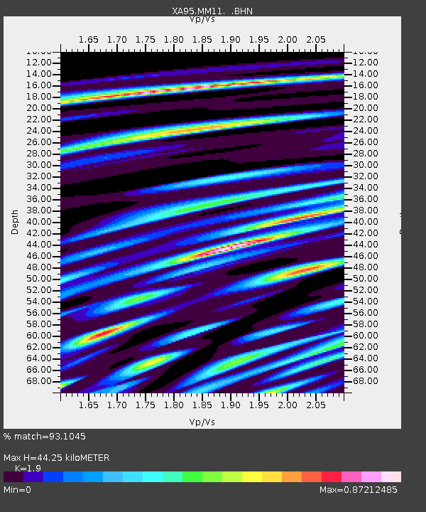
| Estimated Moho Depth: |
44.25 km |
| Estimated Crust Vp/Vs: |
1.90 |
| Assumed Crust Vp: |
6.498 km/s |
| Estimated Crust Vs: |
3.42 km/s |
| Estimated Crust Poisson's Ratio: |
0.31 |
|
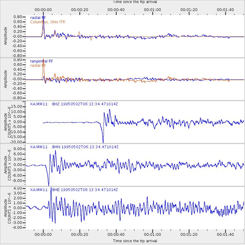
| Radial Match: |
93.1045 % |
| Radial Bump: |
400 |
| Transverse Match: |
76.7545 % |
| Transverse Bump: |
400 |
| SOD ConfigId: |
6273 |
| Insert Time: |
2010-02-26 17:51:34.705 +0000 |
| GWidth: |
2.5 |
| Max Bumps: |
400 |
| Tol: |
0.001 |
|
Signal To Noise
| Channel | StoN | STA | LTA |
| XA:MM11: :BHN:19950502T06:13:34.471014Z | 13.739464 | 4.2553406E-6 | 3.0971663E-7 |
| XA:MM11: :BHE:19950502T06:13:34.471014Z | 4.008571 | 1.2836736E-6 | 3.2023217E-7 |
| XA:MM11: :BHZ:19950502T06:13:34.471014Z | 36.745537 | 6.8675977E-6 | 1.868961E-7 |
| Arrivals |
| Ps | 6.5 SECOND |
| PpPs | 19 SECOND |
| PsPs/PpSs | 25 SECOND |


