You are here: Home > Network List > XA95 - Missouri to Massachusetts Transect Stations List
> Station MM11 Columbus, Ohio > Earthquake Result Viewer
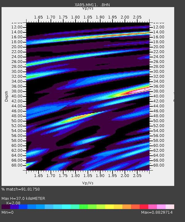
MM11 Columbus, Ohio - Earthquake Result Viewer
| Earthquake location: |
Near Coast Of Peru |
| Earthquake latitude/longitude: |
-10.5/-78.7 |
| Earthquake time(UTC): |
1995/09/23 (266) 22:31:58 GMT |
| Earthquake Depth: |
73 km |
| Earthquake Magnitude: |
5.9 MB, 6.5 UNKNOWN, 6.4 MW |
| Earthquake Catalog/Contributor: |
WHDF/NEIC |
|
| Network: |
XA Missouri to Massachusetts Transect |
| Station: |
MM11 Columbus, Ohio |
| Lat/Lon: |
40.22 N/83.19 W |
| Elevation: |
283 m |
|
| Distance: |
50.7 deg |
| Az: |
355.547 deg |
| Baz: |
174.278 deg |
| Ray Param: |
0.06769053 |
| Estimated Moho Depth: |
37.0 km |
| Estimated Crust Vp/Vs: |
2.08 |
| Assumed Crust Vp: |
6.498 km/s |
| Estimated Crust Vs: |
3.124 km/s |
| Estimated Crust Poisson's Ratio: |
0.35 |
|
| Radial Match: |
91.81758 % |
| Radial Bump: |
357 |
| Transverse Match: |
77.02614 % |
| Transverse Bump: |
400 |
| SOD ConfigId: |
6273 |
| Insert Time: |
2010-02-26 17:51:38.723 +0000 |
| GWidth: |
2.5 |
| Max Bumps: |
400 |
| Tol: |
0.001 |
|

Signal To Noise
| Channel | StoN | STA | LTA |
| XA:MM11: :BHN:19950923T22:40:19.66499Z | 11.008592 | 1.3014158E-6 | 1.1821819E-7 |
| XA:MM11: :BHE:19950923T22:40:19.66499Z | 2.2646716 | 2.7160183E-7 | 1.199299E-7 |
| XA:MM11: :BHZ:19950923T22:40:19.66499Z | 16.026045 | 2.236451E-6 | 1.3955105E-7 |
| Arrivals |
| Ps | 6.5 SECOND |
| PpPs | 17 SECOND |
| PsPs/PpSs | 23 SECOND |


