You are here: Home > Network List > XA95 - Missouri to Massachusetts Transect Stations List
> Station MM14 Brooklyn, Indiana > Earthquake Result Viewer
MM14 Brooklyn, Indiana - Earthquake Result Viewer
| Earthquake location: |
Kuril Islands |
| Earthquake latitude/longitude: |
45.9/151.3 |
| Earthquake time(UTC): |
1995/04/17 (107) 23:28:08 GMT |
| Earthquake Depth: |
34 km |
| Earthquake Magnitude: |
6.1 MB, 6.3 MS, 6.2 UNKNOWN, 6.8 MW |
| Earthquake Catalog/Contributor: |
WHDF/NEIC |
|
| Network: |
XA Missouri to Massachusetts Transect |
| Station: |
MM14 Brooklyn, Indiana |
| Lat/Lon: |
39.55 N/86.39 W |
| Elevation: |
290 m |
|
| Distance: |
80.5 deg |
| Az: |
41.493 deg |
| Baz: |
323.249 deg |
| Ray Param: |
0.04819964 |
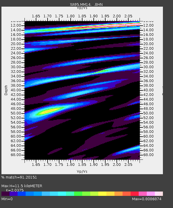
| Estimated Moho Depth: |
11.5 km |
| Estimated Crust Vp/Vs: |
2.04 |
| Assumed Crust Vp: |
6.444 km/s |
| Estimated Crust Vs: |
3.163 km/s |
| Estimated Crust Poisson's Ratio: |
0.34 |
|
| Radial Match: |
91.20151 % |
| Radial Bump: |
351 |
| Transverse Match: |
72.47444 % |
| Transverse Bump: |
400 |
| SOD ConfigId: |
6273 |
| Insert Time: |
2010-02-26 17:53:42.834 +0000 |
| GWidth: |
2.5 |
| Max Bumps: |
400 |
| Tol: |
0.001 |
|
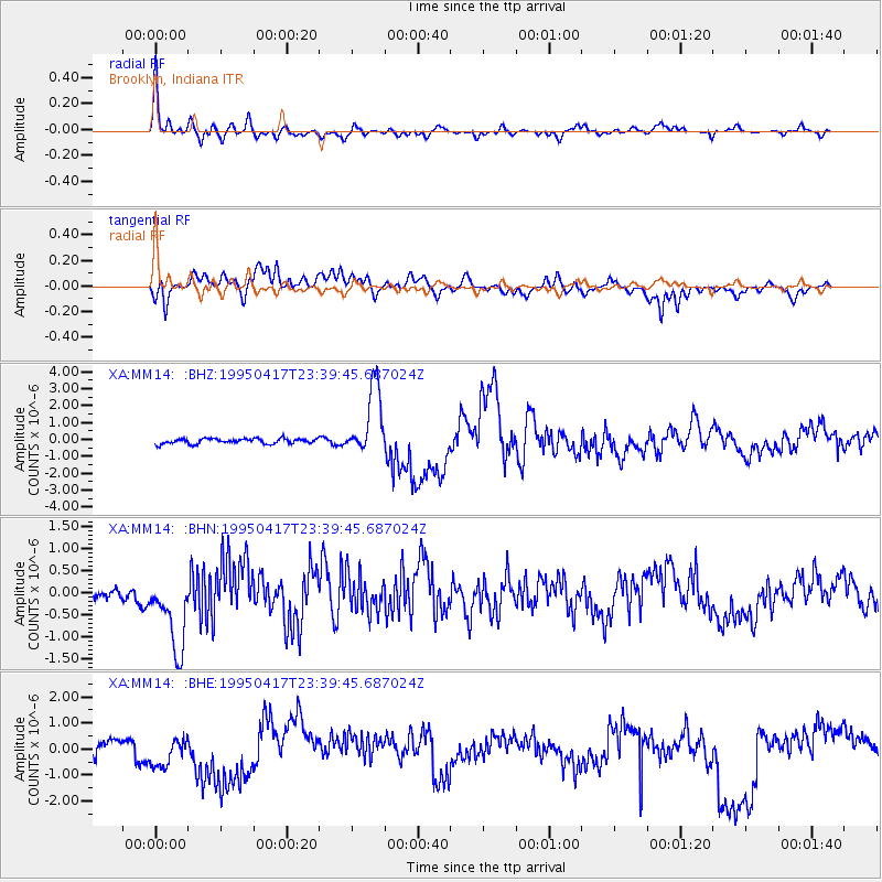
Signal To Noise
| Channel | StoN | STA | LTA |
| XA:MM14: :BHN:19950417T23:39:45.687024Z | 8.64294 | 9.2479934E-7 | 1.0700055E-7 |
| XA:MM14: :BHE:19950417T23:39:45.687024Z | 1.7195737 | 5.7793557E-7 | 3.3609234E-7 |
| XA:MM14: :BHZ:19950417T23:39:45.687024Z | 13.167971 | 2.015196E-6 | 1.5303772E-7 |
| Arrivals |
| Ps | 1.9 SECOND |
| PpPs | 5.3 SECOND |
| PsPs/PpSs | 7.2 SECOND |


