
Station XA MM14 - Brooklyn, Indiana
Network: XA95 - Missouri to Massachusetts Transect
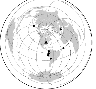
Nearby stations (2 deg radius)
| Station | Name | (Lat, Lon) | Start / End | Elevation |
| MM14 | Brooklyn, Indiana | (39.55, -86.39) | 1995-04-05 / 1996-04-11 | 290 m |
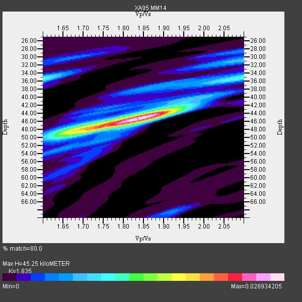
| Crust2 Type: | D6,Platform 2 km seds. |
| Thickness Estimate: | 45 km |
| Thickness StdDev: | 1.3 km |
| Vp/Vs Estimate: | 1.84 |
| Vp/Vs StdDev: | 0.05 |
| Vs Estimate: | 3.512 km/s |
| Poisson's Ratio: | 0.29 |
| Peak Value: | 0.03 |
| Assumed Vp: | 6.444 km/s |
| Ps Weight: | 0.33333334 |
| PpPs Weight: | 0.33333334 |
| PsPs Weight: | 0.33333328 |
| Residual Complexity: | 0.545 |
| Nearby stations H: | +- |
| (2.0 deg) Vp/Vs: | +- |
7 with match > 90% ( 18.918919 %) and 9 with match > 80% ( 24.324324 %) out of 37.
Download stack as xyz text file.
Azimuth Distribution of Events:
Prior Results for this Station
| Study | Thickness | Vp/Vs | Vp | Vs | Poissons Ratio | Extra |
| EARS | 45 km | 1.84 | 6.444 km/s | 3.512 km/s | 0.29 | |
| Crust2.0 | 41 km | 1.78 | 6.444 km/s | 3.629 km/s | 0.27 | D6,Platform 2 km seds. |
| MOMA | 43 km | 1.84 | 6.6 km/s | 3.587 km/s | 0.29 | |
| MOMA | 44 km | 1.80 | 6.6 km/s | 3.667 km/s | 0.28 | |
| MOMA | 47 km | 1.73 | 6.5 km/s | 3.757 km/s | 0.25 | |
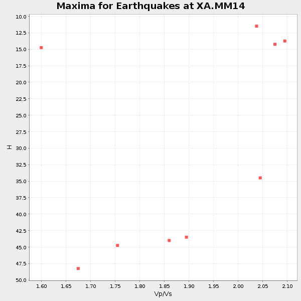
| Global Maxima | 45 km | 1.84 | 6.444 km/s | 3.512 km/s | 0.29 | amp=0.028934205 |
| Local Maxima 1 | 48 km | 1.68 | 6.444 km/s | 3.841 km/s | 0.22 | amp=0.01560995 |
| Local Maxima 2 | 36 km | 1.60 | 6.444 km/s | 4.027 km/s | 0.18 | amp=0.011584092 |
| Local Maxima 3 | 35 km | 2.09 | 6.444 km/s | 3.091 km/s | 0.35 | amp=0.008811642 |
| Local Maxima 4 | 31 km | 2.09 | 6.444 km/s | 3.083 km/s | 0.35 | amp=0.007970244 |
| Predicted Arrivals for vertical incidence (zero ray parameter) | |
| Ps | 5.86 SECOND |
| PpPs | 19.91 SECOND |
| PsPs/PpSs | 25.77 SECOND |
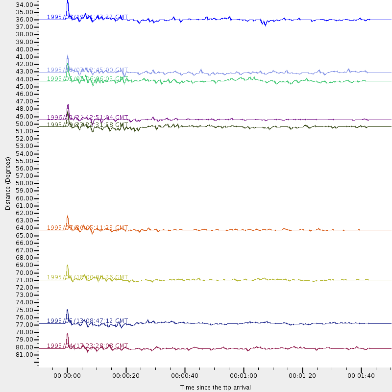
Events Processed for this Station
Download zip of receiver functions as SAC
Plot maxima for each earthquake.
Events Used in the Stack
(9 events)| Radial Match | Distance | Baz | FERegion | Time | Lat/Lon | Depth | Magnitude |
| 96.40888 | 71.1 deg | 107.633 deg | Central Mid-Atlantic Ridge | 1995/05/18 00:06:26 GMT | (-0.9, -22.0) | 10 km | 6.2 MB, 6.1 MS, 6.8 UNKNOWN, 6.7 MW |
| 96.07906 | 64.4 deg | 163.598 deg | Near Coast Of Northern Chile | 1995/07/30 05:11:23 GMT | (-23.4, -70.3) | 47 km | 6.6 MB, 7.3 MS, 7.2 UNKNOWN, 8.1 MW |
| 95.6298 | 49.3 deg | 171.109 deg | Off Coast Of Northern Peru | 1996/02/21 12:51:04 GMT | (-9.6, -79.6) | 33 km | 5.8 MB, 6.6 MS, 7.5 UNKNOWN, 7.3 MW |
| 95.349594 | 35.6 deg | 161.485 deg | Colombia | 1995/08/19 21:43:32 GMT | (5.1, -75.7) | 125 km | 6.1 MB, 6.6 UNKNOWN, 6.5 MW |
| 91.20151 | 80.5 deg | 323.249 deg | Kuril Islands | 1995/04/17 23:28:08 GMT | (45.9, 151.3) | 34 km | 6.1 MB, 6.3 MS, 6.2 UNKNOWN, 6.8 MW |
| 91.03981 | 50.3 deg | 170.147 deg | Near Coast Of Peru | 1995/09/23 22:31:58 GMT | (-10.5, -78.7) | 73 km | 5.9 MB, 6.5 UNKNOWN, 6.4 MW |
| 90.64073 | 77.1 deg | 48.383 deg | Greece | 1995/05/13 08:47:12 GMT | (40.1, 21.7) | 13 km | 6.2 MB, 6.5 MS, 6.6 UNKNOWN, 6.5 MD |
| 83.18348 | 44.1 deg | 166.393 deg | Northern Peru | 1995/05/02 06:06:05 GMT | (-3.9, -77.0) | 103 km | 6.5 MB, 6.7 UNKNOWN, 6.6 MW |
| 80.163666 | 42.9 deg | 167.472 deg | Peru-Ecuador Border Region | 1995/10/03 12:45:00 GMT | (-2.8, -77.9) | 33 km | 6.0 MB, 6.1 MS, 5.9 UNKNOWN, 6.4 MW |
Losers
(28 events)| Radial Match | Distance | Baz | FERegion | Time | Lat/Lon | Depth | Magnitude | Reason |
| 74.843056 | 69.6 deg | 166.092 deg | Near Coast Of Central Chile | 1995/11/01 00:35:32 GMT | (-29.0, -71.5) | 20 km | 6.3 MB, 6.4 MS, 6.3 UNKNOWN, 6.7 MW | |
| 73.96259 | 64.1 deg | 163.826 deg | Near Coast Of Northern Chile | 1995/08/03 01:57:21 GMT | (-23.1, -70.6) | 33 km | 5.4 MB, 5.9 MS, 5.7 UNKNOWN, 6.3 MW | |
| 72.20898 | 83.5 deg | 325.303 deg | Kuril Islands | 1996/02/01 07:18:05 GMT | (44.9, 146.3) | 180 km | 5.7 MB, 6.2 UNKNOWN, 6.2 MW | |
| 69.88714 | 64.3 deg | 163.862 deg | Near Coast Of Northern Chile | 1995/07/30 21:05:50 GMT | (-23.3, -70.6) | 33 km | 5.6 MB, 5.6 MS, 5.4 UNKNOWN, 6.1 MW | |
| 66.6205 | 83.4 deg | 323.806 deg | Kuril Islands | 1995/04/28 16:30:00 GMT | (44.1, 148.1) | 29 km | 6.6 MB, 6.9 MS, 7.0 UNKNOWN, 6.8 MW | |
| 66.1137 | 92.7 deg | 48.678 deg | Egypt | 1995/11/22 04:15:11 GMT | (28.8, 34.9) | 10 km | 6.2 MB, 7.3 MS, 7.2 UNKNOWN, 6.2 ML | |
| 65.097595 | 78.8 deg | 331.893 deg | Sakhalin, Russia | 1995/05/27 13:03:55 GMT | (52.6, 142.8) | 33 km | 6.6 MB, 7.6 MS, 7.0 UNKNOWN, 7.0 MW | |
| 62.677853 | 63.2 deg | 315.396 deg | Rat Islands, Aleutian Islands | 1996/03/22 03:24:20 GMT | (51.2, 178.7) | 20 km | 5.7 MB, 6.6 MS, 6.8 UNKNOWN, 6.6 ML | |
| 61.787296 | 55.7 deg | 312.434 deg | Fox Islands, Aleutian Islands | 1996/03/30 13:05:17 GMT | (52.2, -168.7) | 33 km | 5.9 MB, 6.2 MS, 6.3 UNKNOWN, 6.1 ML | |
| 61.745888 | 62.7 deg | 161.428 deg | Chile-Bolivia Border Region | 1995/09/19 03:31:53 GMT | (-21.2, -68.7) | 110 km | 5.7 MB, 5.7 UNKNOWN, 5.6 MW | |
| 61.064358 | 82.3 deg | 324.264 deg | Kuril Islands | 1996/02/22 14:59:09 GMT | (45.2, 148.6) | 133 km | 6.2 MB, 6.3 UNKNOWN, 6.3 MW | |
| 58.196068 | 76.8 deg | 196.533 deg | Southern East Pacific Rise | 1995/10/12 23:41:45 GMT | (-35.4, -106.2) | 10 km | 5.5 MB, 5.3 MS, 5.9 UNKNOWN | |
| 56.837975 | 81.9 deg | 171.521 deg | Off Coast Of Southern Chile | 1996/02/19 07:10:10 GMT | (-42.1, -75.1) | 33 km | 5.9 MB, 5.3 MS, 5.9 UNKNOWN, 5.9 MW | |
| 56.51854 | 74.1 deg | 323.734 deg | Kuril Islands | 1995/09/30 10:47:56 GMT | (50.8, 157.4) | 33 km | 5.7 MB, 5.5 MS | |
| 55.012318 | 74.1 deg | 167.304 deg | Near Coast Of Central Chile | 1996/02/22 13:40:53 GMT | (-33.7, -71.7) | 44 km | 5.9 MB, 5.5 MS, 6.0 UNKNOWN, 5.9 MW | |
| 50.69711 | 76.9 deg | 323.624 deg | Kuril Islands | 1995/06/29 07:45:09 GMT | (48.8, 154.5) | 62 km | 5.9 MB, 6.0 UNKNOWN, 6.0 MW | |
| 49.325474 | 69.4 deg | 163.838 deg | Chile-Argentina Border Region | 1995/08/03 08:18:53 GMT | (-28.3, -69.2) | 104 km | 5.9 MB, 5.8 UNKNOWN, 5.9 MW | |
| 47.16464 | 68.0 deg | 51.729 deg | Corsica, France | 1995/05/02 12:28:27 GMT | (43.2, 9.4) | 10 km | 5.9 UNKNOWN, 5.9 MW | |
| 42.29189 | 89.0 deg | 323.885 deg | Off East Coast Of Honshu, Japan | 1995/07/08 05:42:56 GMT | (39.6, 143.4) | 40 km | 5.7 MB, 5.5 MS, 5.2 UNKNOWN, 6.0 MW | |
| 38.98557 | 83.3 deg | 45.275 deg | Turkey | 1995/10/01 15:57:16 GMT | (38.1, 30.2) | 33 km | 5.7 MB, 6.1 MS, 6.3 UNKNOWN, 6.0 MW | |
| 32.859158 | 97.3 deg | 256.578 deg | Tonga Islands | 1996/02/16 11:34:30 GMT | (-15.1, -173.6) | 33 km | 5.6 MS, 5.1 MB | |
| 29.086525 | 83.1 deg | 348.39 deg | East Of Lake Baykal, Russia | 1995/11/13 08:43:14 GMT | (56.1, 114.5) | 24 km | 5.9 MB, 5.6 MS, 5.8 UNKNOWN | |
| 15.854269 | 81.3 deg | 323.399 deg | Kuril Islands | 1996/02/14 20:31:06 GMT | (45.4, 150.4) | 33 km | 5.9 MB, 5.2 MS, 5.8 UNKNOWN, 5.8 MW | |
| 14.925575 | 52.3 deg | 312.787 deg | Unimak Island Region, Alaska | 1995/07/08 17:15:28 GMT | (53.6, -163.5) | 33 km | 5.8 MB, 5.7 MS, 5.5 UNKNOWN, 6.0 MW | |
| 14.674958 | 58.6 deg | 313.246 deg | Andreanof Islands, Aleutian Is. | 1995/10/30 20:25:28 GMT | (51.7, -173.4) | 33 km | 5.4 MB, 5.3 MS, 5.8 UNKNOWN, 5.6 ML | |
| 14.235247 | 42.9 deg | 167.381 deg | Peru-Ecuador Border Region | 1995/10/07 21:28:06 GMT | (-2.8, -77.8) | 33 km | 5.8 MB, 5.2 MS, 5.8 UNKNOWN | |
| 13.027845 | 77.1 deg | 48.491 deg | Greece | 1995/05/15 04:13:55 GMT | (40.0, 21.6) | 10 km | 5.5 MD, 5.1 MB | |
| 12.428755 | 82.5 deg | 323.328 deg | Kuril Islands | 1996/01/31 20:30:47 GMT | (44.5, 149.4) | 58 km | 5.8 MB, 6.1 UNKNOWN, 5.9 MW |
