You are here: Home > Network List > XA95 - Missouri to Massachusetts Transect Stations List
> Station MM14 Brooklyn, Indiana > Earthquake Result Viewer
MM14 Brooklyn, Indiana - Earthquake Result Viewer
| Earthquake location: |
Northern Peru |
| Earthquake latitude/longitude: |
-3.9/-77.0 |
| Earthquake time(UTC): |
1995/05/02 (122) 06:06:05 GMT |
| Earthquake Depth: |
103 km |
| Earthquake Magnitude: |
6.5 MB, 6.7 UNKNOWN, 6.6 MW |
| Earthquake Catalog/Contributor: |
WHDF/NEIC |
|
| Network: |
XA Missouri to Massachusetts Transect |
| Station: |
MM14 Brooklyn, Indiana |
| Lat/Lon: |
39.55 N/86.39 W |
| Elevation: |
290 m |
|
| Distance: |
44.1 deg |
| Az: |
349.496 deg |
| Baz: |
166.393 deg |
| Ray Param: |
0.07180824 |
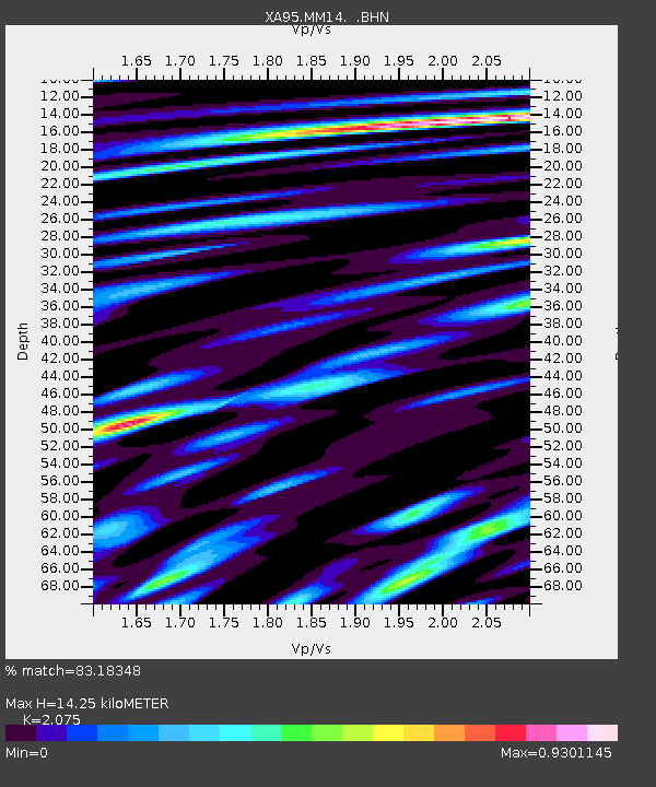
| Estimated Moho Depth: |
14.25 km |
| Estimated Crust Vp/Vs: |
2.08 |
| Assumed Crust Vp: |
6.444 km/s |
| Estimated Crust Vs: |
3.105 km/s |
| Estimated Crust Poisson's Ratio: |
0.35 |
|
| Radial Match: |
83.18348 % |
| Radial Bump: |
400 |
| Transverse Match: |
31.095535 % |
| Transverse Bump: |
400 |
| SOD ConfigId: |
6273 |
| Insert Time: |
2010-02-26 17:53:44.710 +0000 |
| GWidth: |
2.5 |
| Max Bumps: |
400 |
| Tol: |
0.001 |
|
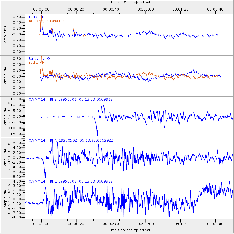
Signal To Noise
| Channel | StoN | STA | LTA |
| XA:MM14: :BHN:19950502T06:13:33.066992Z | 11.005137 | 2.897591E-6 | 2.632944E-7 |
| XA:MM14: :BHE:19950502T06:13:33.066992Z | 1.3483069 | 1.5705468E-6 | 1.164829E-6 |
| XA:MM14: :BHZ:19950502T06:13:33.066992Z | 37.465176 | 6.177054E-6 | 1.6487454E-7 |
| Arrivals |
| Ps | 2.5 SECOND |
| PpPs | 6.4 SECOND |
| PsPs/PpSs | 8.9 SECOND |


