You are here: Home > Network List > XA95 - Missouri to Massachusetts Transect Stations List
> Station MM14 Brooklyn, Indiana > Earthquake Result Viewer
MM14 Brooklyn, Indiana - Earthquake Result Viewer
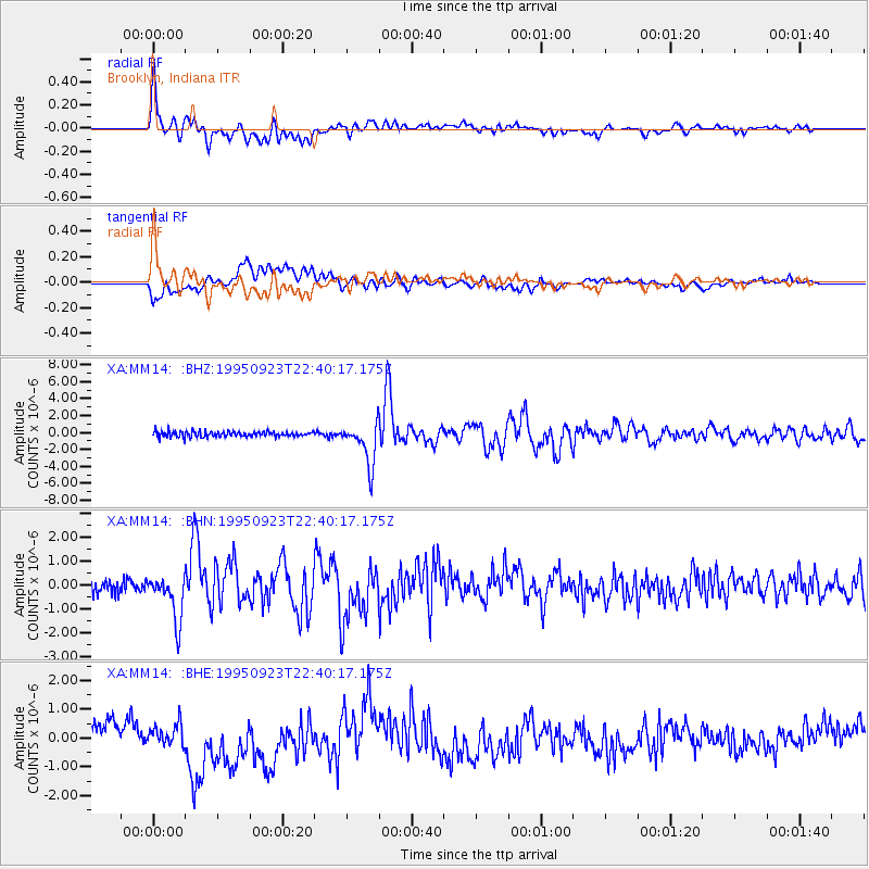
| Earthquake location: |
Near Coast Of Peru |
| Earthquake latitude/longitude: |
-10.5/-78.7 |
| Earthquake time(UTC): |
1995/09/23 (266) 22:31:58 GMT |
| Earthquake Depth: |
73 km |
| Earthquake Magnitude: |
5.9 MB, 6.5 UNKNOWN, 6.4 MW |
| Earthquake Catalog/Contributor: |
WHDF/NEIC |
|
| Network: |
XA Missouri to Massachusetts Transect |
| Station: |
MM14 Brooklyn, Indiana |
| Lat/Lon: |
39.55 N/86.39 W |
| Elevation: |
290 m |
|
| Distance: |
50.3 deg |
| Az: |
352.268 deg |
| Baz: |
170.147 deg |
| Ray Param: |
0.06790341 |
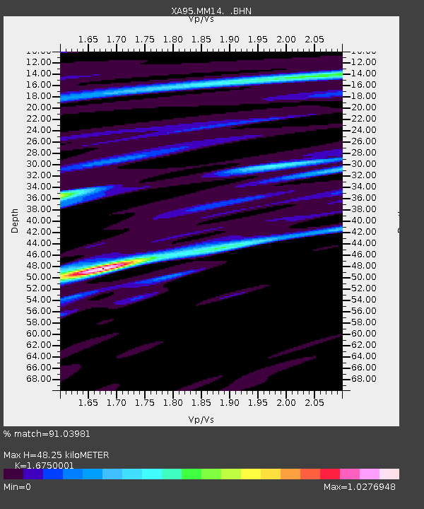
| Estimated Moho Depth: |
48.25 km |
| Estimated Crust Vp/Vs: |
1.68 |
| Assumed Crust Vp: |
6.444 km/s |
| Estimated Crust Vs: |
3.847 km/s |
| Estimated Crust Poisson's Ratio: |
0.22 |
|
| Radial Match: |
91.03981 % |
| Radial Bump: |
400 |
| Transverse Match: |
50.588673 % |
| Transverse Bump: |
400 |
| SOD ConfigId: |
6273 |
| Insert Time: |
2010-02-26 17:53:50.796 +0000 |
| GWidth: |
2.5 |
| Max Bumps: |
400 |
| Tol: |
0.001 |
|
Signal To Noise
| Channel | StoN | STA | LTA |
| XA:MM14: :BHN:19950923T22:40:17.175Z | 2.116637 | 9.467598E-7 | 4.4729435E-7 |
| XA:MM14: :BHE:19950923T22:40:17.175Z | 0.8220572 | 4.273122E-7 | 5.1980834E-7 |
| XA:MM14: :BHZ:19950923T22:40:17.175Z | 7.844187 | 2.4849428E-6 | 3.167878E-7 |
| Arrivals |
| Ps | 5.4 SECOND |
| PpPs | 19 SECOND |
| PsPs/PpSs | 24 SECOND |


