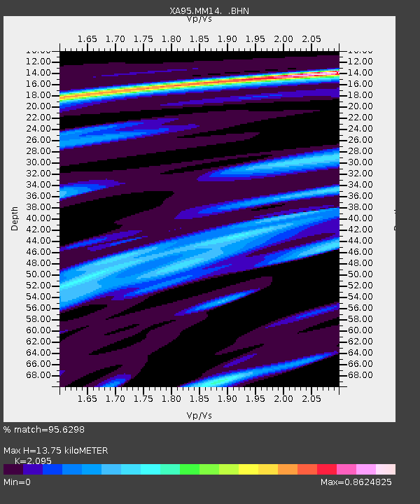
MM14 Brooklyn, Indiana - Earthquake Result Viewer
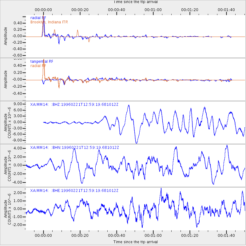
Earthquake location: Off Coast Of Northern Peru
Earthquake latitude/longitude: -9.6/-79.6
Earthquake time(UTC): 1996/02/21 (052) 12:51:04 GMT
Earthquake Depth: 33 km
Earthquake Magnitude: 5.8 MB, 6.6 MS, 7.5 UNKNOWN, 7.3 MW
Earthquake Catalog/Contributor: WHDF/NEIC
Network: XA Missouri to Massachusetts Transect
Station: MM14 Brooklyn, Indiana
Lat/Lon: 39.55 N/86.39 W
Elevation: 290 m
Distance: 49.3 deg
Az: 353.04 deg
Baz: 171.109 deg
Ray Param: 0.06870852
Estimated Moho Depth: 13.75 km
Estimated Crust Vp/Vs: 2.10
Assumed Crust Vp: 6.444 km/s
Estimated Crust Vs: 3.076 km/s
Estimated Crust Poisson's Ratio: 0.35
Radial Match: 95.6298 %
Radial Bump: 296
Transverse Match: 69.41923 %
Transverse Bump: 400
SOD ConfigId: 6273
Insert Time: 2010-02-26 17:53:52.238 +0000
GWidth: 2.5
Max Bumps: 400
Tol: 0.001

Signal To Noise

ChannelStoNSTALTA
XA:MM14: :BHN:19960221T12:59:19.681012Z3.63243228.187844E-72.254094E-7
XA:MM14: :BHE:19960221T12:59:19.681012Z1.19062975.8319296E-74.898189E-7
XA:MM14: :BHZ:19960221T12:59:19.681012Z6.1873841.7495107E-62.827545E-7
Arrivals
Ps2.5 SECOND
PpPs6.3 SECOND
PsPs/PpSs8.7 SECOND