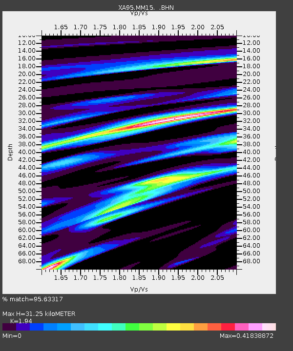
MM15 Terra Haute, Indiana - Earthquake Result Viewer
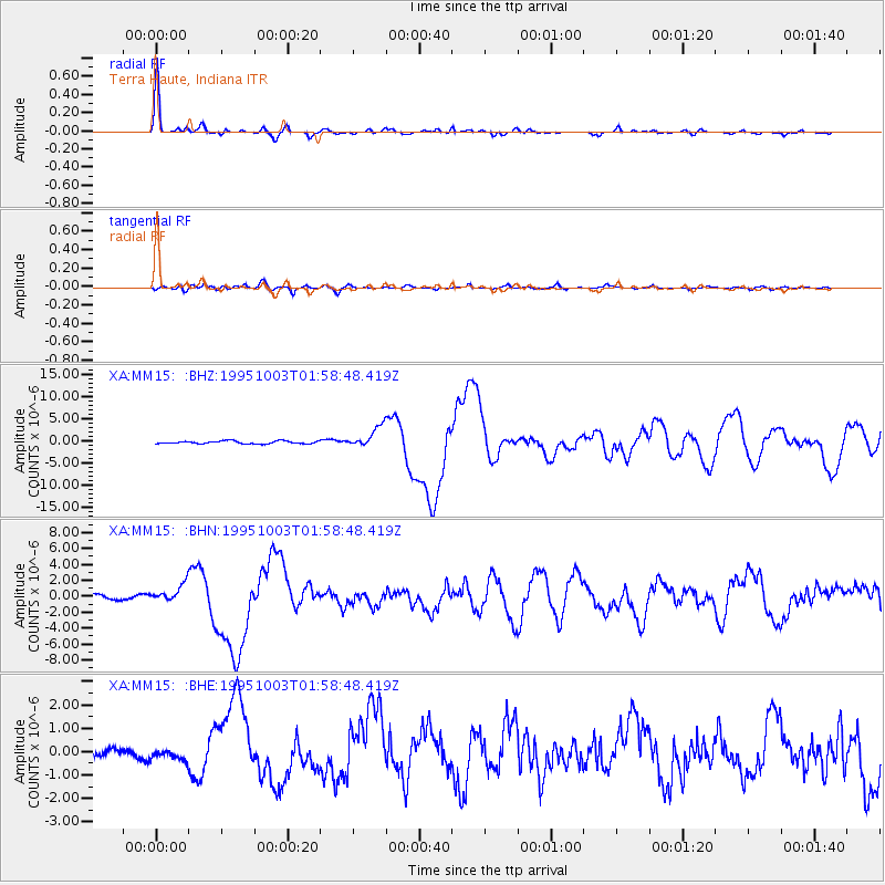
Earthquake location: Peru-Ecuador Border Region
Earthquake latitude/longitude: -2.8/-77.9
Earthquake time(UTC): 1995/10/03 (276) 01:51:24 GMT
Earthquake Depth: 27 km
Earthquake Magnitude: 6.5 MB, 7.0 MS, 6.9 UNKNOWN, 7.0 MW
Earthquake Catalog/Contributor: WHDF/NEIC
Network: XA Missouri to Massachusetts Transect
Station: MM15 Terra Haute, Indiana
Lat/Lon: 39.29 N/87.31 W
Elevation: 191 m
Distance: 42.8 deg
Az: 349.206 deg
Baz: 166.051 deg
Ray Param: 0.07293935
Estimated Moho Depth: 31.25 km
Estimated Crust Vp/Vs: 1.94
Assumed Crust Vp: 6.444 km/s
Estimated Crust Vs: 3.322 km/s
Estimated Crust Poisson's Ratio: 0.32
Radial Match: 95.63317 %
Radial Bump: 285
Transverse Match: 82.55641 %
Transverse Bump: 400
SOD ConfigId: 6273
Insert Time: 2010-02-26 17:54:23.999 +0000
GWidth: 2.5
Max Bumps: 400
Tol: 0.001

Signal To Noise

ChannelStoNSTALTA
XA:MM15: :BHN:19951003T01:58:48.419Z4.14568471.1814986E-62.8499483E-7
XA:MM15: :BHE:19951003T01:58:48.419Z1.27491932.583953E-72.026758E-7
XA:MM15: :BHZ:19951003T01:58:48.419Z7.61473852.3206953E-63.0476363E-7
Arrivals
Ps4.8 SECOND
PpPs13 SECOND
PsPs/PpSs18 SECOND