
Station XA MM15 - Terra Haute, Indiana
Network: XA95 - Missouri to Massachusetts Transect
Nearby stations (2 deg radius)
| Station | Name | (Lat, Lon) | Start / End | Elevation |
| MM15 | Terra Haute, Indiana | (39.29, -87.31) | 1995-03-03 / 1996-03-28 | 191 m |
| Crust2 Type: | D6,Platform 2 km seds. |
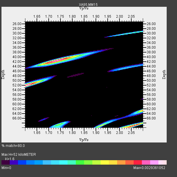
| Thickness Estimate: | 52 km |
| Thickness StdDev: | 10 km |
| Vp/Vs Estimate: | 1.60 |
| Vp/Vs StdDev: | 0.19 |
| Vs Estimate: | 4.027 km/s |
| Poisson's Ratio: | 0.18 |
| Peak Value: | 0.00 |
| Assumed Vp: | 6.444 km/s |
| Ps Weight: | 0.33333334 |
| PpPs Weight: | 0.33333334 |
| PsPs Weight: | 0.33333328 |
| Residual Complexity: | 0.853 |
| Nearby stations H: | +- |
| (2.0 deg) Vp/Vs: | +- |
8 with match > 90% ( 32.0 %) and 9 with match > 80% ( 36.0 %) out of 25.
Download stack as xyz text file.
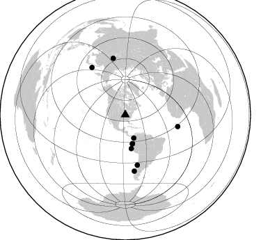
Azimuth Distribution of Events:
Prior Results for this Station
| Study | Thickness | Vp/Vs | Vp | Vs | Poissons Ratio | Extra |
| EARS | 52 km | 1.60 | 6.444 km/s | 4.027 km/s | 0.18 | |
| Crust2.0 | 41 km | 1.78 | 6.444 km/s | 3.629 km/s | 0.27 | D6,Platform 2 km seds. |
| Global Maxima | 52 km | 1.60 | 6.444 km/s | 4.027 km/s | 0.18 | amp=0.0029361052 |
| Local Maxima 1 | 42 km | 1.73 | 6.444 km/s | 3.725 km/s | 0.25 | amp=0.0026805846 |
| Local Maxima 2 | 69 km | 2.06 | 6.444 km/s | 3.132 km/s | 0.35 | amp=0.0025962458 |
| Local Maxima 3 | 62 km | 2.10 | 6.444 km/s | 3.072 km/s | 0.35 | amp=0.0022330629 |
| Local Maxima 4 | 69 km | 1.92 | 6.444 km/s | 3.356 km/s | 0.31 | amp=0.00180289 |
| Predicted Arrivals for vertical incidence (zero ray parameter) | |
| Ps | 4.84 SECOND |
| PpPs | 20.98 SECOND |
| PsPs/PpSs | 25.82 SECOND |
Events Processed for this Station
Download zip of receiver functions as SAC
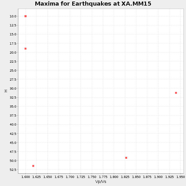
Plot maxima for each earthquake.
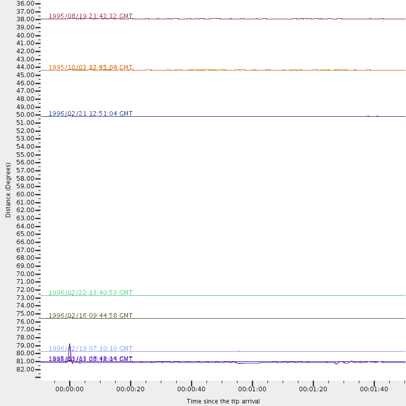
Events Used in the Stack
(9 events)| Radial Match | Distance | Baz | FERegion | Time | Lat/Lon | Depth | Magnitude |
| 99.94538 | 77.2 deg | 102.701 deg | North Of Ascension Island | 1996/02/16 09:44:58 GMT | (-1.5, -15.2) | 10 km | 6.0 MB, 6.3 MS, 6.5 UNKNOWN, 6.4 MW |
| 99.9314 | 83.2 deg | 347.898 deg | East Of Lake Baykal, Russia | 1995/11/13 08:43:14 GMT | (56.1, 114.5) | 24 km | 5.9 MB, 5.6 MS, 5.8 UNKNOWN |
| 99.92942 | 49.2 deg | 169.887 deg | Off Coast Of Northern Peru | 1996/02/21 12:51:04 GMT | (-9.6, -79.6) | 33 km | 5.8 MB, 6.6 MS, 7.5 UNKNOWN, 7.3 MW |
| 99.925354 | 81.8 deg | 170.834 deg | Off Coast Of Southern Chile | 1996/02/19 07:10:10 GMT | (-42.1, -75.1) | 33 km | 5.9 MB, 5.3 MS, 5.9 UNKNOWN, 5.9 MW |
| 99.90812 | 74.0 deg | 166.509 deg | Near Coast Of Central Chile | 1996/02/22 13:40:53 GMT | (-33.7, -71.7) | 44 km | 5.9 MB, 5.5 MS, 6.0 UNKNOWN, 5.9 MW |
| 95.63317 | 42.8 deg | 166.051 deg | Peru-Ecuador Border Region | 1995/10/03 01:51:24 GMT | (-2.8, -77.9) | 27 km | 6.5 MB, 7.0 MS, 6.9 UNKNOWN, 7.0 MW |
| 93.15526 | 83.3 deg | 324.806 deg | Kuril Islands | 1996/02/01 07:18:05 GMT | (44.9, 146.3) | 180 km | 5.7 MB, 6.2 UNKNOWN, 6.2 MW |
| 91.68741 | 35.6 deg | 159.85 deg | Colombia | 1995/08/19 21:43:32 GMT | (5.1, -75.7) | 125 km | 6.1 MB, 6.6 UNKNOWN, 6.5 MW |
| 84.58198 | 42.8 deg | 166.081 deg | Peru-Ecuador Border Region | 1995/10/03 12:45:00 GMT | (-2.8, -77.9) | 33 km | 6.0 MB, 6.1 MS, 5.9 UNKNOWN, 6.4 MW |
Losers
(16 events)| Radial Match | Distance | Baz | FERegion | Time | Lat/Lon | Depth | Magnitude | Reason |
| 69.37047 | 83.7 deg | 322.926 deg | East Of Kuril Islands | 1996/03/09 16:15:36 GMT | (43.4, 148.0) | 33 km | 5.6 MB, 5.9 MS, 6.1 UNKNOWN, 5.5 MS | |
| 61.24365 | 87.1 deg | 324.591 deg | Hokkaido, Japan Region | 1995/09/26 07:14:37 GMT | (41.8, 143.4) | 36 km | 5.7 MB, 5.5 MS, 5.9 UNKNOWN, 5.8 MW | |
| 60.805725 | 69.5 deg | 165.23 deg | Near Coast Of Central Chile | 1995/11/01 00:35:32 GMT | (-29.0, -71.5) | 20 km | 6.3 MB, 6.4 MS, 6.3 UNKNOWN, 6.7 MW | |
| 53.578243 | 82.3 deg | 323.055 deg | Kuril Islands | 1995/11/24 17:24:12 GMT | (44.5, 149.1) | 33 km | 6.1 MB, 6.3 MS, 6.1 UNKNOWN, 6.6 MW | |
| 53.030693 | 82.2 deg | 322.844 deg | Kuril Islands | 1996/01/31 20:30:47 GMT | (44.5, 149.4) | 58 km | 5.8 MB, 6.1 UNKNOWN, 5.9 MW | |
| 52.463818 | 97.8 deg | 257.61 deg | Samoa Islands Region | 1995/03/03 21:12:37 GMT | (-14.6, -175.6) | 22 km | 5.6 MB, 5.7 MS, 5.9 UNKNOWN, 5.9 MW | |
| 50.79244 | 83.2 deg | 323.235 deg | Kuril Islands | 1995/03/11 15:21:10 GMT | (44.0, 148.1) | 33 km | 6.0 MB, 5.7 MS, 6.1 UNKNOWN, 5.9 MW | |
| 49.864536 | 96.5 deg | 255.939 deg | Tonga Islands | 1995/11/13 07:38:45 GMT | (-15.1, -173.5) | 33 km | 5.7 MB, 5.9 MS, 6.1 UNKNOWN, 6.0 MW | |
| 46.642048 | 42.8 deg | 165.99 deg | Peru-Ecuador Border Region | 1995/10/07 21:28:06 GMT | (-2.8, -77.8) | 33 km | 5.8 MB, 5.2 MS, 5.8 UNKNOWN | |
| 44.67951 | 50.3 deg | 313.694 deg | Alaska Peninsula | 1995/03/14 17:33:50 GMT | (54.8, -161.3) | 33 km | 6.1 MB, 5.9 MS, 6.2 UNKNOWN, 5.5 ML | |
| 44.03315 | 33.1 deg | 125.266 deg | Leeward Islands | 1995/03/08 03:45:59 GMT | (16.6, -59.6) | 15 km | 6.3 MB, 6.2 MS, 6.4 UNKNOWN, 6.1 MD | |
| 40.931175 | 84.0 deg | 44.73 deg | Turkey | 1995/10/01 15:57:16 GMT | (38.1, 30.2) | 33 km | 5.7 MB, 6.1 MS, 6.3 UNKNOWN, 6.0 MW | |
| 40.7637 | 58.2 deg | 313.078 deg | Andreanof Islands, Aleutian Is. | 1995/10/30 20:25:28 GMT | (51.7, -173.4) | 33 km | 5.4 MB, 5.3 MS, 5.8 UNKNOWN, 5.6 ML | |
| 38.239372 | 62.7 deg | 160.456 deg | Chile-Bolivia Border Region | 1995/09/19 03:31:53 GMT | (-21.2, -68.7) | 110 km | 5.7 MB, 5.7 UNKNOWN, 5.6 MW | |
| 29.61186 | 83.6 deg | 327.093 deg | Sakhalin, Russia | 1995/03/10 05:22:22 GMT | (46.1, 143.5) | 350 km | 5.7 UNKNOWN, 5.4 MB | |
| 23.063461 | 73.9 deg | 323.36 deg | Kuril Islands | 1995/09/30 10:47:56 GMT | (50.8, 157.4) | 33 km | 5.7 MB, 5.5 MS |
