You are here: Home > Network List > XA95 - Missouri to Massachusetts Transect Stations List
> Station MM15 Terra Haute, Indiana > Earthquake Result Viewer
MM15 Terra Haute, Indiana - Earthquake Result Viewer
| Earthquake location: |
Kuril Islands |
| Earthquake latitude/longitude: |
44.9/146.3 |
| Earthquake time(UTC): |
1996/02/01 (032) 07:18:05 GMT |
| Earthquake Depth: |
180 km |
| Earthquake Magnitude: |
5.7 MB, 6.2 UNKNOWN, 6.2 MW |
| Earthquake Catalog/Contributor: |
WHDF/NEIC |
|
| Network: |
XA Missouri to Massachusetts Transect |
| Station: |
MM15 Terra Haute, Indiana |
| Lat/Lon: |
39.29 N/87.31 W |
| Elevation: |
191 m |
|
| Distance: |
83.3 deg |
| Az: |
38.968 deg |
| Baz: |
324.806 deg |
| Ray Param: |
0.045827117 |
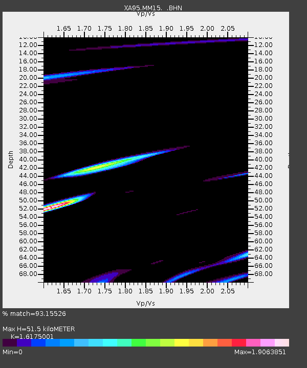
| Estimated Moho Depth: |
51.5 km |
| Estimated Crust Vp/Vs: |
1.62 |
| Assumed Crust Vp: |
6.444 km/s |
| Estimated Crust Vs: |
3.984 km/s |
| Estimated Crust Poisson's Ratio: |
0.19 |
|
| Radial Match: |
93.15526 % |
| Radial Bump: |
176 |
| Transverse Match: |
93.2284 % |
| Transverse Bump: |
175 |
| SOD ConfigId: |
29242 |
| Insert Time: |
2010-02-26 17:54:37.444 +0000 |
| GWidth: |
2.5 |
| Max Bumps: |
400 |
| Tol: |
0.001 |
|

Signal To Noise
| Channel | StoN | STA | LTA |
| XA:MM15: :BHN:19960201T07:29:40.85603Z | 1.0359156 | 1.2759997E-6 | 1.2317602E-6 |
| XA:MM15: :BHE:19960201T07:29:40.85603Z | 0.96143144 | 1.3213481E-6 | 1.3743551E-6 |
| XA:MM15: :BHZ:19960201T07:29:40.85603Z | 1.6324348 | 5.3558216E-7 | 3.280879E-7 |
| Arrivals |
| Ps | 5.1 SECOND |
| PpPs | 20 SECOND |
| PsPs/PpSs | 25 SECOND |


