You are here: Home > Network List > XA95 - Missouri to Massachusetts Transect Stations List
> Station MM17 Lake Carlyle, Illinois > Earthquake Result Viewer
MM17 Lake Carlyle, Illinois - Earthquake Result Viewer

| Earthquake location: |
Northern Peru |
| Earthquake latitude/longitude: |
-3.9/-77.0 |
| Earthquake time(UTC): |
1995/05/02 (122) 06:06:05 GMT |
| Earthquake Depth: |
103 km |
| Earthquake Magnitude: |
6.5 MB, 6.7 UNKNOWN, 6.6 MW |
| Earthquake Catalog/Contributor: |
WHDF/NEIC |
|
| Network: |
XA Missouri to Massachusetts Transect |
| Station: |
MM17 Lake Carlyle, Illinois |
| Lat/Lon: |
38.67 N/89.33 W |
| Elevation: |
144 m |
|
| Distance: |
43.8 deg |
| Az: |
345.989 deg |
| Baz: |
162.026 deg |
| Ray Param: |
0.071945764 |
| Estimated Moho Depth: |
34.25 km |
| Estimated Crust Vp/Vs: |
1.91 |
| Assumed Crust Vp: |
6.444 km/s |
| Estimated Crust Vs: |
3.374 km/s |
| Estimated Crust Poisson's Ratio: |
0.31 |
|
| Radial Match: |
87.37981 % |
| Radial Bump: |
400 |
| Transverse Match: |
72.65569 % |
| Transverse Bump: |
400 |
| SOD ConfigId: |
6273 |
| Insert Time: |
2010-02-26 17:56:13.129 +0000 |
| GWidth: |
2.5 |
| Max Bumps: |
400 |
| Tol: |
0.001 |
|
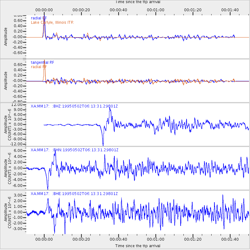
Signal To Noise
| Channel | StoN | STA | LTA |
| XA:MM17: :BHN:19950502T06:13:31.29801Z | 17.992384 | 2.6686994E-6 | 1.4832383E-7 |
| XA:MM17: :BHE:19950502T06:13:31.29801Z | 4.3573155 | 9.3650243E-7 | 2.1492646E-7 |
| XA:MM17: :BHZ:19950502T06:13:31.29801Z | 20.799767 | 4.480404E-6 | 2.1540647E-7 |
| Arrivals |
| Ps | 5.1 SECOND |
| PpPs | 15 SECOND |
| PsPs/PpSs | 20 SECOND |


