
Station XA MM17 - Lake Carlyle, Illinois
Network: XA95 - Missouri to Massachusetts Transect
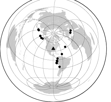
Nearby stations (2 deg radius)
| Station | Name | (Lat, Lon) | Start / End | Elevation |
| MM17 | Lake Carlyle, Illinois | (38.67, -89.33) | 1995-03-03 / 1996-04-05 | 144 m |
| Crust2 Type: | D6,Platform 2 km seds. |
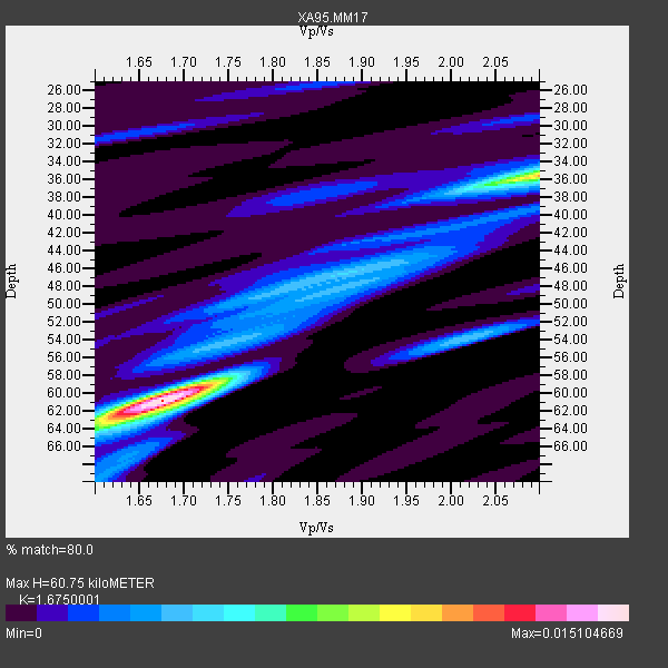
| Thickness Estimate: | 61 km |
| Thickness StdDev: | 10 km |
| Vp/Vs Estimate: | 1.68 |
| Vp/Vs StdDev: | 0.16 |
| Vs Estimate: | 3.847 km/s |
| Poisson's Ratio: | 0.22 |
| Peak Value: | 0.02 |
| Assumed Vp: | 6.444 km/s |
| Ps Weight: | 0.33333334 |
| PpPs Weight: | 0.33333334 |
| PsPs Weight: | 0.33333328 |
| Residual Complexity: | 0.564 |
| Nearby stations H: | +- |
| (2.0 deg) Vp/Vs: | +- |
9 with match > 90% ( 19.565218 %) and 20 with match > 80% ( 43.47826 %) out of 46.
Download stack as xyz text file.
Azimuth Distribution of Events:
Prior Results for this Station
| Study | Thickness | Vp/Vs | Vp | Vs | Poissons Ratio | Extra |
| EARS | 61 km | 1.68 | 6.444 km/s | 3.847 km/s | 0.22 | |
| Crust2.0 | 41 km | 1.78 | 6.444 km/s | 3.629 km/s | 0.27 | D6,Platform 2 km seds. |
| MOMA | 41 km | 1.84 | 6.6 km/s | 3.587 km/s | 0.29 | |
| MOMA | 43 km | 1.80 | 6.6 km/s | 3.667 km/s | 0.28 | |
| MOMA | 46 km | 1.73 | 6.5 km/s | 3.757 km/s | 0.25 | |
| Global Maxima | 61 km | 1.68 | 6.444 km/s | 3.847 km/s | 0.22 | amp=0.015104669 |
| Local Maxima 1 | 36 km | 2.10 | 6.444 km/s | 3.072 km/s | 0.35 | amp=0.010300668 |
| Local Maxima 2 | 46 km | 1.89 | 6.444 km/s | 3.409 km/s | 0.31 | amp=0.00394652 |
| Local Maxima 3 | 58 km | 1.74 | 6.444 km/s | 3.714 km/s | 0.25 | amp=0.0030193464 |
| Local Maxima 4 | 63 km | 1.63 | 6.444 km/s | 3.953 km/s | 0.20 | amp=0.00269593 |
| Predicted Arrivals for vertical incidence (zero ray parameter) | |
| Ps | 6.36 SECOND |
| PpPs | 25.22 SECOND |
| PsPs/PpSs | 31.58 SECOND |
Events Processed for this Station
Download zip of receiver functions as SAC
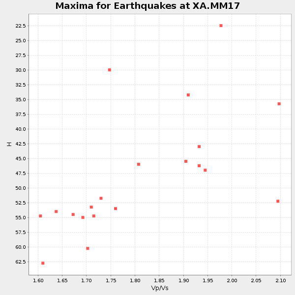
Plot maxima for each earthquake.
Events Used in the Stack
(20 events)| Radial Match | Distance | Baz | FERegion | Time | Lat/Lon | Depth | Magnitude |
| 97.57627 | 64.2 deg | 160.582 deg | Near Coast Of Northern Chile | 1995/07/30 05:11:23 GMT | (-23.4, -70.3) | 47 km | 6.6 MB, 7.3 MS, 7.2 UNKNOWN, 8.1 MW |
| 97.25126 | 48.9 deg | 167.185 deg | Off Coast Of Northern Peru | 1996/02/21 12:51:04 GMT | (-9.6, -79.6) | 33 km | 5.8 MB, 6.6 MS, 7.5 UNKNOWN, 7.3 MW |
| 96.313416 | 42.6 deg | 162.969 deg | Peru-Ecuador Border Region | 1995/10/03 01:51:24 GMT | (-2.8, -77.9) | 27 km | 6.5 MB, 7.0 MS, 6.9 UNKNOWN, 7.0 MW |
| 95.85488 | 81.7 deg | 321.886 deg | Kuril Islands | 1995/12/03 18:01:08 GMT | (44.6, 149.4) | 33 km | 6.6 MB, 8.0 MS |
| 94.68029 | 35.6 deg | 156.235 deg | Colombia | 1995/08/19 21:43:32 GMT | (5.1, -75.7) | 125 km | 6.1 MB, 6.6 UNKNOWN, 6.5 MW |
| 93.96988 | 79.8 deg | 321.815 deg | Kuril Islands | 1995/04/17 23:28:08 GMT | (45.9, 151.3) | 34 km | 6.1 MB, 6.3 MS, 6.2 UNKNOWN, 6.8 MW |
| 91.94051 | 62.2 deg | 314.709 deg | Rat Islands, Aleutian Islands | 1996/03/22 03:24:20 GMT | (51.2, 178.7) | 20 km | 5.7 MB, 6.6 MS, 6.8 UNKNOWN, 6.6 ML |
| 91.738205 | 61.6 deg | 314.495 deg | Rat Islands, Aleutian Islands | 1995/04/23 02:55:54 GMT | (51.3, 179.7) | 16 km | 6.1 MB, 6.4 MS, 6.5 UNKNOWN, 6.7 ML |
| 90.00194 | 49.9 deg | 166.291 deg | Near Coast Of Peru | 1995/09/23 22:31:58 GMT | (-10.5, -78.7) | 73 km | 5.9 MB, 6.5 UNKNOWN, 6.4 MW |
| 88.39085 | 40.8 deg | 80.742 deg | Northern Mid-Atlantic Ridge | 1995/04/17 07:14:35 GMT | (33.8, -38.6) | 10 km | 5.8 MB, 5.8 MS, 5.9 UNKNOWN, 6.1 MW |
| 87.53114 | 49.6 deg | 313.722 deg | Alaska Peninsula | 1995/03/14 17:33:50 GMT | (54.8, -161.3) | 33 km | 6.1 MB, 5.9 MS, 6.2 UNKNOWN, 5.5 ML |
| 87.41832 | 64.1 deg | 160.84 deg | Near Coast Of Northern Chile | 1995/07/30 21:05:50 GMT | (-23.3, -70.6) | 33 km | 5.6 MB, 5.6 MS, 5.4 UNKNOWN, 6.1 MW |
| 87.37981 | 43.8 deg | 162.026 deg | Northern Peru | 1995/05/02 06:06:05 GMT | (-3.9, -77.0) | 103 km | 6.5 MB, 6.7 UNKNOWN, 6.6 MW |
| 87.21924 | 80.9 deg | 322.121 deg | Kuril Islands | 1996/02/07 21:36:45 GMT | (45.3, 149.9) | 33 km | 6.3 MB, 7.0 MS, 7.2 UNKNOWN, 7.1 MW |
| 85.47016 | 42.6 deg | 163.002 deg | Peru-Ecuador Border Region | 1995/10/03 12:45:00 GMT | (-2.8, -77.9) | 33 km | 6.0 MB, 6.1 MS, 5.9 UNKNOWN, 6.4 MW |
| 84.77982 | 79.4 deg | 46.727 deg | Greece | 1995/05/13 08:47:12 GMT | (40.1, 21.7) | 13 km | 6.2 MB, 6.5 MS, 6.6 UNKNOWN, 6.5 MD |
| 82.62685 | 34.1 deg | 121.919 deg | Leeward Islands | 1995/03/08 03:45:59 GMT | (16.6, -59.6) | 15 km | 6.3 MB, 6.2 MS, 6.4 UNKNOWN, 6.1 MD |
| 82.16272 | 85.5 deg | 43.533 deg | Turkey | 1995/10/01 15:57:16 GMT | (38.1, 30.2) | 33 km | 5.7 MB, 6.1 MS, 6.3 UNKNOWN, 6.0 MW |
| 80.22818 | 54.6 deg | 312.112 deg | Fox Islands, Aleutian Islands | 1996/03/30 13:05:17 GMT | (52.2, -168.7) | 33 km | 5.9 MB, 6.2 MS, 6.3 UNKNOWN, 6.1 ML |
| 80.07918 | 82.7 deg | 322.251 deg | Kuril Islands | 1995/04/28 16:30:00 GMT | (44.1, 148.1) | 29 km | 6.6 MB, 6.9 MS, 7.0 UNKNOWN, 6.8 MW |
Losers
(26 events)| Radial Match | Distance | Baz | FERegion | Time | Lat/Lon | Depth | Magnitude | Reason |
| 79.85576 | 81.6 deg | 322.756 deg | Kuril Islands | 1996/02/22 14:59:09 GMT | (45.2, 148.6) | 133 km | 6.2 MB, 6.3 UNKNOWN, 6.3 MW | |
| 79.28817 | 71.7 deg | 322.987 deg | Off East Coast Of Kamchatka | 1995/04/01 05:50:20 GMT | (52.3, 159.1) | 47 km | 5.9 MB, 5.6 MS, 5.3 UNKNOWN, 6.0 MW | |
| 73.613045 | 76.2 deg | 322.344 deg | Kuril Islands | 1995/06/29 07:45:09 GMT | (48.8, 154.5) | 62 km | 5.9 MB, 6.0 UNKNOWN, 6.0 MW | |
| 72.42082 | 63.9 deg | 160.795 deg | Near Coast Of Northern Chile | 1995/08/03 01:57:21 GMT | (-23.1, -70.6) | 33 km | 5.4 MB, 5.9 MS, 5.7 UNKNOWN, 6.3 MW | |
| 72.07883 | 69.3 deg | 161.077 deg | Chile-Argentina Border Region | 1995/08/03 08:18:53 GMT | (-28.3, -69.2) | 104 km | 5.9 MB, 5.8 UNKNOWN, 5.9 MW | |
| 72.071 | 40.7 deg | 163.634 deg | Ecuador | 1996/03/28 23:03:49 GMT | (-1.0, -78.7) | 33 km | 5.8 MB, 5.2 MS, 5.9 UNKNOWN, 5.1 MS | |
| 70.82508 | 81.4 deg | 169.329 deg | Off Coast Of Southern Chile | 1996/02/19 07:10:10 GMT | (-42.1, -75.1) | 33 km | 5.9 MB, 5.3 MS, 5.9 UNKNOWN, 5.9 MW | |
| 69.77181 | 73.8 deg | 164.766 deg | Near Coast Of Central Chile | 1996/02/22 13:40:53 GMT | (-33.7, -71.7) | 44 km | 5.9 MB, 5.5 MS, 6.0 UNKNOWN, 5.9 MW | |
| 68.30516 | 82.9 deg | 323.742 deg | Kuril Islands | 1996/02/01 07:18:05 GMT | (44.9, 146.3) | 180 km | 5.7 MB, 6.2 UNKNOWN, 6.2 MW | |
| 65.88546 | 81.8 deg | 322.02 deg | Kuril Islands | 1995/11/24 17:24:12 GMT | (44.5, 149.1) | 33 km | 6.1 MB, 6.3 MS, 6.1 UNKNOWN, 6.6 MW | |
| 64.30481 | 69.3 deg | 163.338 deg | Near Coast Of Central Chile | 1995/11/01 00:35:32 GMT | (-29.0, -71.5) | 20 km | 6.3 MB, 6.4 MS, 6.3 UNKNOWN, 6.7 MW | |
| 63.288605 | 62.6 deg | 158.323 deg | Chile-Bolivia Border Region | 1995/09/19 03:31:53 GMT | (-21.2, -68.7) | 110 km | 5.7 MB, 5.7 UNKNOWN, 5.6 MW | |
| 63.07794 | 83.5 deg | 346.832 deg | East Of Lake Baykal, Russia | 1995/11/13 08:43:14 GMT | (56.1, 114.5) | 24 km | 5.9 MB, 5.6 MS, 5.8 UNKNOWN | |
| 62.563976 | 79.4 deg | 46.834 deg | Greece | 1995/05/15 04:13:55 GMT | (40.0, 21.6) | 10 km | 5.5 MD, 5.1 MB | |
| 62.34792 | 57.5 deg | 312.775 deg | Andreanof Islands, Aleutian Is. | 1995/10/30 20:25:28 GMT | (51.7, -173.4) | 33 km | 5.4 MB, 5.3 MS, 5.8 UNKNOWN, 5.6 ML | |
| 60.73281 | 51.2 deg | 312.675 deg | Unimak Island Region, Alaska | 1995/07/08 17:15:28 GMT | (53.6, -163.5) | 33 km | 5.8 MB, 5.7 MS, 5.5 UNKNOWN, 6.0 MW | |
| 59.25592 | 42.6 deg | 162.909 deg | Peru-Ecuador Border Region | 1995/10/07 21:28:06 GMT | (-2.8, -77.8) | 33 km | 5.8 MB, 5.2 MS, 5.8 UNKNOWN | |
| 56.66807 | 73.5 deg | 322.576 deg | Kuril Islands | 1995/09/30 10:47:56 GMT | (50.8, 157.4) | 33 km | 5.7 MB, 5.5 MS | |
| 54.539455 | 75.4 deg | 194.204 deg | Southern East Pacific Rise | 1995/10/12 23:41:45 GMT | (-35.4, -106.2) | 10 km | 5.5 MB, 5.3 MS, 5.9 UNKNOWN | |
| 51.585476 | 80.6 deg | 321.931 deg | Kuril Islands | 1996/02/14 20:31:06 GMT | (45.4, 150.4) | 33 km | 5.9 MB, 5.2 MS, 5.8 UNKNOWN, 5.8 MW | |
| 51.00296 | 82.7 deg | 322.149 deg | Kuril Islands | 1995/04/19 03:50:05 GMT | (44.0, 148.2) | 33 km | 5.9 MB, 5.5 MS, 5.8 UNKNOWN, 5.7 MW | |
| 49.784336 | 86.6 deg | 323.42 deg | Hokkaido, Japan Region | 1995/09/26 07:14:37 GMT | (41.8, 143.4) | 36 km | 5.7 MB, 5.5 MS, 5.9 UNKNOWN, 5.8 MW | |
| 46.98477 | 95.9 deg | 322.724 deg | Near S. Coast Of Honshu, Japan | 1995/07/07 21:15:18 GMT | (33.9, 137.1) | 324 km | 5.8 MB, 6.0 UNKNOWN, 6.0 MW | |
| 42.436348 | 89.1 deg | 352.357 deg | Lake Baykal Region, Russia | 1995/06/29 23:02:31 GMT | (51.9, 103.1) | 33 km | 5.6 MB, 5.5 MS, 5.7 UNKNOWN | |
| 40.484955 | 83.2 deg | 326.023 deg | Sakhalin, Russia | 1995/03/10 05:22:22 GMT | (46.1, 143.5) | 350 km | 5.7 UNKNOWN, 5.4 MB | |
| 20.321215 | 88.3 deg | 322.097 deg | Off East Coast Of Honshu, Japan | 1995/07/08 05:42:56 GMT | (39.6, 143.4) | 40 km | 5.7 MB, 5.5 MS, 5.2 UNKNOWN, 6.0 MW |
