You are here: Home > Network List > XA95 - Missouri to Massachusetts Transect Stations List
> Station MM17 Lake Carlyle, Illinois > Earthquake Result Viewer
MM17 Lake Carlyle, Illinois - Earthquake Result Viewer
| Earthquake location: |
Turkey |
| Earthquake latitude/longitude: |
38.1/30.2 |
| Earthquake time(UTC): |
1995/10/01 (274) 15:57:16 GMT |
| Earthquake Depth: |
33 km |
| Earthquake Magnitude: |
5.7 MB, 6.1 MS, 6.3 UNKNOWN, 6.0 MW |
| Earthquake Catalog/Contributor: |
WHDF/NEIC |
|
| Network: |
XA Missouri to Massachusetts Transect |
| Station: |
MM17 Lake Carlyle, Illinois |
| Lat/Lon: |
38.67 N/89.33 W |
| Elevation: |
144 m |
|
| Distance: |
85.5 deg |
| Az: |
316.889 deg |
| Baz: |
43.533 deg |
| Ray Param: |
0.044667367 |
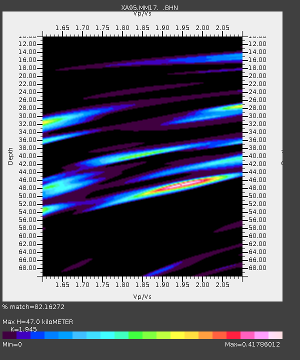
| Estimated Moho Depth: |
47.0 km |
| Estimated Crust Vp/Vs: |
1.95 |
| Assumed Crust Vp: |
6.444 km/s |
| Estimated Crust Vs: |
3.313 km/s |
| Estimated Crust Poisson's Ratio: |
0.32 |
|
| Radial Match: |
82.16272 % |
| Radial Bump: |
400 |
| Transverse Match: |
48.417297 % |
| Transverse Bump: |
400 |
| SOD ConfigId: |
6273 |
| Insert Time: |
2010-02-26 17:56:27.076 +0000 |
| GWidth: |
2.5 |
| Max Bumps: |
400 |
| Tol: |
0.001 |
|

Signal To Noise
| Channel | StoN | STA | LTA |
| XA:MM17: :BHN:19951001T16:09:19.43103Z | 1.0155562 | 2.802395E-7 | 2.759468E-7 |
| XA:MM17: :BHE:19951001T16:09:19.43103Z | 1.5480075 | 3.603626E-7 | 2.3279125E-7 |
| XA:MM17: :BHZ:19951001T16:09:19.43103Z | 3.142774 | 7.1000466E-7 | 2.2591654E-7 |
| Arrivals |
| Ps | 7.0 SECOND |
| PpPs | 21 SECOND |
| PsPs/PpSs | 28 SECOND |


