You are here: Home > Network List > XA95 - Missouri to Massachusetts Transect Stations List
> Station MM17 Lake Carlyle, Illinois > Earthquake Result Viewer
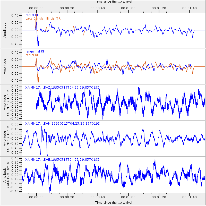
MM17 Lake Carlyle, Illinois - Earthquake Result Viewer
*The percent match for this event was below the threshold and hence no stack was calculated.
| Earthquake location: |
Greece |
| Earthquake latitude/longitude: |
40.0/21.6 |
| Earthquake time(UTC): |
1995/05/15 (135) 04:13:55 GMT |
| Earthquake Depth: |
10 km |
| Earthquake Magnitude: |
5.5 MD, 5.1 MB |
| Earthquake Catalog/Contributor: |
WHDF/NEIC |
|
| Network: |
XA Missouri to Massachusetts Transect |
| Station: |
MM17 Lake Carlyle, Illinois |
| Lat/Lon: |
38.67 N/89.33 W |
| Elevation: |
144 m |
|
| Distance: |
79.4 deg |
| Az: |
311.945 deg |
| Baz: |
46.834 deg |
| Ray Param: |
$rayparam |
*The percent match for this event was below the threshold and hence was not used in the summary stack. |
|
| Radial Match: |
62.563976 % |
| Radial Bump: |
400 |
| Transverse Match: |
48.822266 % |
| Transverse Bump: |
400 |
| SOD ConfigId: |
4480 |
| Insert Time: |
2010-02-26 17:56:45.742 +0000 |
| GWidth: |
2.5 |
| Max Bumps: |
400 |
| Tol: |
0.001 |
|
Signal To Noise
| Channel | StoN | STA | LTA |
| XA:MM17: :BHN:19950515T04:25:29.857019Z | 1.9099728 | 3.0075142E-7 | 1.5746373E-7 |
| XA:MM17: :BHE:19950515T04:25:29.857019Z | 0.9565932 | 1.18560855E-7 | 1.2394072E-7 |
| XA:MM17: :BHZ:19950515T04:25:29.857019Z | 1.5548998 | 1.9641209E-7 | 1.2631817E-7 |
| Arrivals |
| Ps | |
| PpPs | |
| PsPs/PpSs | |


