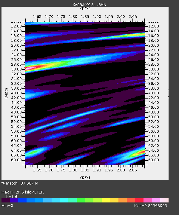
MO18 Tyson (bunker), Missouri - Earthquake Result Viewer

Earthquake location: Fox Islands, Aleutian Islands
Earthquake latitude/longitude: 52.2/-168.7
Earthquake time(UTC): 1996/03/30 (090) 13:05:17 GMT
Earthquake Depth: 33 km
Earthquake Magnitude: 5.9 MB, 6.2 MS, 6.3 UNKNOWN, 6.1 ML
Earthquake Catalog/Contributor: WHDF/NEIC
Network: XA Missouri to Massachusetts Transect
Station: MO18 Tyson (bunker), Missouri
Lat/Lon: 38.51 N/90.56 W
Elevation: 161 m
Distance: 54.0 deg
Az: 71.643 deg
Baz: 311.892 deg
Ray Param: 0.06566509
Estimated Moho Depth: 29.5 km
Estimated Crust Vp/Vs: 1.60
Assumed Crust Vp: 6.498 km/s
Estimated Crust Vs: 4.061 km/s
Estimated Crust Poisson's Ratio: 0.18
Radial Match: 87.66744 %
Radial Bump: 400
Transverse Match: 62.987083 %
Transverse Bump: 400
SOD ConfigId: 6273
Insert Time: 2010-02-26 17:57:52.868 +0000
GWidth: 2.5
Max Bumps: 400
Tol: 0.001

Signal To Noise

ChannelStoNSTALTA
XA:MO18: :BHN:19960330T13:14:07.576025Z3.4879386.0340665E-71.729981E-7
XA:MO18: :BHE:19960330T13:14:07.576025Z2.51003535.179044E-72.0633351E-7
XA:MO18: :BHZ:19960330T13:14:07.576025Z7.7233571.5298734E-61.9808398E-7
Arrivals
Ps2.9 SECOND
PpPs11 SECOND
PsPs/PpSs14 SECOND