
Station XA MO18 - Tyson (bunker), Missouri
Network: XA95 - Missouri to Massachusetts Transect
Nearby stations (2 deg radius)
| Station | Name | (Lat, Lon) | Start / End | Elevation |
| MO18 | Tyson (bunker), Missouri | (38.51, -90.56) | 1996-01-25 / 1996-04-07 | 161 m |
| Crust2 Type: | D9,Platform 1 km seds. |
| Thickness Estimate: | 38 km |
| Thickness StdDev: | 11 km |
| Vp/Vs Estimate: | 2.10 |
| Vp/Vs StdDev: | 0.20 |
| Vs Estimate: | 3.101 km/s |
| Poisson's Ratio: | 0.35 |
| Peak Value: | 0.02 |
| Assumed Vp: | 6.498 km/s |
| Ps Weight: | 0.33333334 |
| PpPs Weight: | 0.33333334 |
| PsPs Weight: | 0.33333328 |
| Residual Complexity: | 0.818 |
| Nearby stations H: | 36 km +- 2.1 km |
| (2.0 deg) Vp/Vs: | 1.95 +- 0.21 |
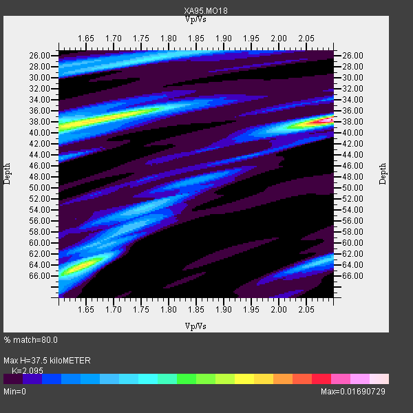
3 with match > 90% ( 30.0 %) and 5 with match > 80% ( 50.0 %) out of 10.
Download stack as xyz text file.
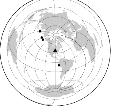
Azimuth Distribution of Events:
Prior Results for this Station
| Study | Thickness | Vp/Vs | Vp | Vs | Poissons Ratio | Extra |
| EARS | 38 km | 2.10 | 6.498 km/s | 3.101 km/s | 0.35 | |
| Crust2.0 | 41 km | 1.77 | 6.498 km/s | 3.666 km/s | 0.27 | D9,Platform 1 km seds. |
| Global Maxima | 38 km | 2.10 | 6.498 km/s | 3.101 km/s | 0.35 | amp=0.01690729 |
| Local Maxima 1 | 37 km | 1.70 | 6.498 km/s | 3.822 km/s | 0.24 | amp=0.011248113 |
| Local Maxima 2 | 64 km | 1.65 | 6.498 km/s | 3.944 km/s | 0.21 | amp=0.0090687005 |
| Local Maxima 3 | 26 km | 1.78 | 6.498 km/s | 3.655 km/s | 0.27 | amp=0.0061198343 |
| Local Maxima 4 | 63 km | 2.09 | 6.498 km/s | 3.116 km/s | 0.35 | amp=0.0052235415 |
| Predicted Arrivals for vertical incidence (zero ray parameter) | |
| Ps | 6.32 SECOND |
| PpPs | 17.86 SECOND |
| PsPs/PpSs | 24.18 SECOND |
Events Processed for this Station
Download zip of receiver functions as SAC
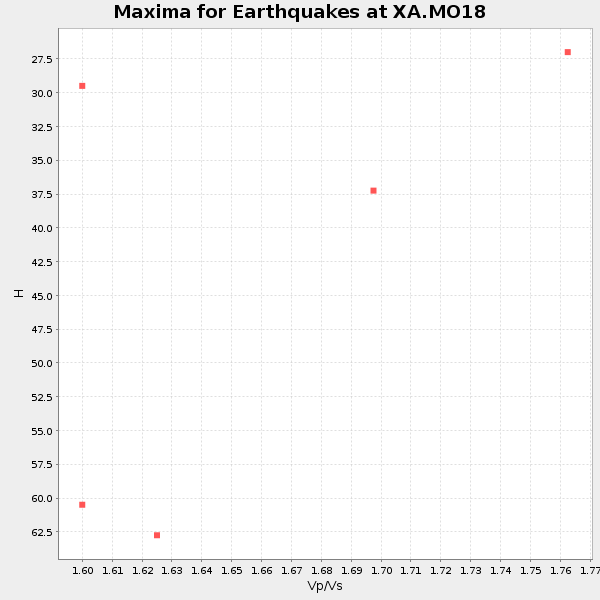
Plot maxima for each earthquake.
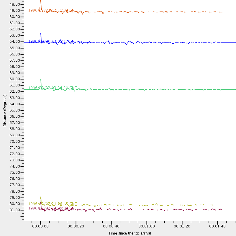
Events Used in the Stack
(5 events)| Radial Match | Distance | Baz | FERegion | Time | Lat/Lon | Depth | Magnitude |
| 97.61051 | 49.0 deg | 165.561 deg | Off Coast Of Northern Peru | 1996/02/21 12:51:04 GMT | (-9.6, -79.6) | 33 km | 5.8 MB, 6.6 MS, 7.5 UNKNOWN, 7.3 MW |
| 95.71428 | 61.6 deg | 314.363 deg | Rat Islands, Aleutian Islands | 1996/03/22 03:24:20 GMT | (51.2, 178.7) | 20 km | 5.7 MB, 6.6 MS, 6.8 UNKNOWN, 6.6 ML |
| 94.02887 | 80.4 deg | 321.493 deg | Kuril Islands | 1996/02/07 21:36:45 GMT | (45.3, 149.9) | 33 km | 6.3 MB, 7.0 MS, 7.2 UNKNOWN, 7.1 MW |
| 87.66744 | 54.0 deg | 311.892 deg | Fox Islands, Aleutian Islands | 1996/03/30 13:05:17 GMT | (52.2, -168.7) | 33 km | 5.9 MB, 6.2 MS, 6.3 UNKNOWN, 6.1 ML |
| 83.108765 | 81.1 deg | 322.118 deg | Kuril Islands | 1996/02/22 14:59:09 GMT | (45.2, 148.6) | 133 km | 6.2 MB, 6.3 UNKNOWN, 6.3 MW |
Losers
(5 events)| Radial Match | Distance | Baz | FERegion | Time | Lat/Lon | Depth | Magnitude | Reason |
| 78.89141 | 73.9 deg | 163.715 deg | Near Coast Of Central Chile | 1996/02/22 13:40:53 GMT | (-33.7, -71.7) | 44 km | 5.9 MB, 5.5 MS, 6.0 UNKNOWN, 5.9 MW | |
| 74.20838 | 81.5 deg | 168.412 deg | Off Coast Of Southern Chile | 1996/02/19 07:10:10 GMT | (-42.1, -75.1) | 33 km | 5.9 MB, 5.3 MS, 5.9 UNKNOWN, 5.9 MW | |
| 71.093025 | 54.0 deg | 312.012 deg | Fox Islands, Aleutian Islands | 1996/03/28 19:51:07 GMT | (52.3, -168.8) | 33 km | 5.7 MB, 5.4 MS, 5.8 UNKNOWN, 5.7 ML | |
| 70.50471 | 40.8 deg | 161.736 deg | Ecuador | 1996/03/28 23:03:49 GMT | (-1.0, -78.7) | 33 km | 5.8 MB, 5.2 MS, 5.9 UNKNOWN, 5.1 MS | |
| 54.095493 | 80.1 deg | 321.307 deg | Kuril Islands | 1996/02/14 20:31:06 GMT | (45.4, 150.4) | 33 km | 5.9 MB, 5.2 MS, 5.8 UNKNOWN, 5.8 MW |
