You are here: Home > Network List > XA95 - Missouri to Massachusetts Transect Stations List
> Station MO18 Tyson (bunker), Missouri > Earthquake Result Viewer
MO18 Tyson (bunker), Missouri - Earthquake Result Viewer
| Earthquake location: |
Kuril Islands |
| Earthquake latitude/longitude: |
45.3/149.9 |
| Earthquake time(UTC): |
1996/02/07 (038) 21:36:45 GMT |
| Earthquake Depth: |
33 km |
| Earthquake Magnitude: |
6.3 MB, 7.0 MS, 7.2 UNKNOWN, 7.1 MW |
| Earthquake Catalog/Contributor: |
WHDF/NEIC |
|
| Network: |
XA Missouri to Massachusetts Transect |
| Station: |
MO18 Tyson (bunker), Missouri |
| Lat/Lon: |
38.51 N/90.56 W |
| Elevation: |
161 m |
|
| Distance: |
80.4 deg |
| Az: |
43.812 deg |
| Baz: |
321.493 deg |
| Ray Param: |
0.048256166 |
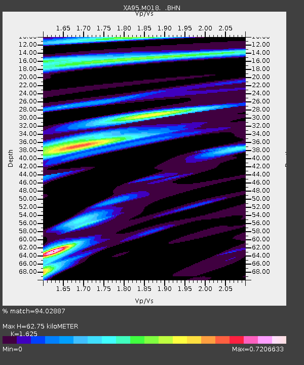
| Estimated Moho Depth: |
62.75 km |
| Estimated Crust Vp/Vs: |
1.62 |
| Assumed Crust Vp: |
6.498 km/s |
| Estimated Crust Vs: |
3.998 km/s |
| Estimated Crust Poisson's Ratio: |
0.20 |
|
| Radial Match: |
94.02887 % |
| Radial Bump: |
363 |
| Transverse Match: |
76.42397 % |
| Transverse Bump: |
400 |
| SOD ConfigId: |
6273 |
| Insert Time: |
2010-02-26 17:57:56.848 +0000 |
| GWidth: |
2.5 |
| Max Bumps: |
400 |
| Tol: |
0.001 |
|

Signal To Noise
| Channel | StoN | STA | LTA |
| XA:MO18: :BHN:19960207T21:48:22.175012Z | 2.1229234 | 5.815456E-7 | 2.7393622E-7 |
| XA:MO18: :BHE:19960207T21:48:22.175012Z | 0.6505558 | 5.0168507E-7 | 7.711638E-7 |
| XA:MO18: :BHZ:19960207T21:48:22.175012Z | 6.8662124 | 2.2771596E-6 | 3.316471E-7 |
| Arrivals |
| Ps | 6.2 SECOND |
| PpPs | 25 SECOND |
| PsPs/PpSs | 31 SECOND |


