You are here: Home > Network List > XA95 - Missouri to Massachusetts Transect Stations List
> Station MO18 Tyson (bunker), Missouri > Earthquake Result Viewer
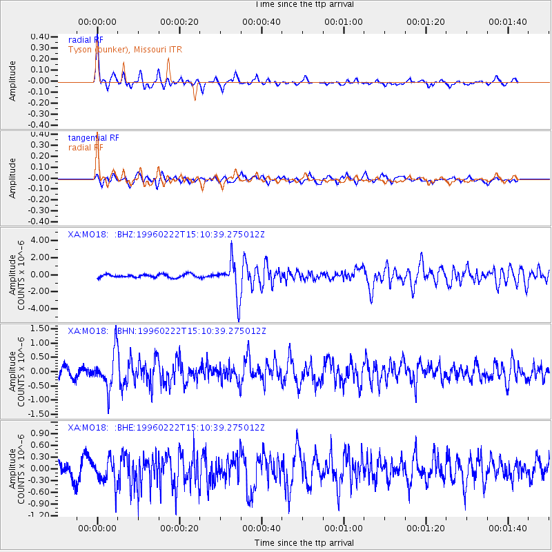
MO18 Tyson (bunker), Missouri - Earthquake Result Viewer

| Earthquake location: |
Kuril Islands |
| Earthquake latitude/longitude: |
45.2/148.6 |
| Earthquake time(UTC): |
1996/02/22 (053) 14:59:09 GMT |
| Earthquake Depth: |
133 km |
| Earthquake Magnitude: |
6.2 MB, 6.3 UNKNOWN, 6.3 MW |
| Earthquake Catalog/Contributor: |
WHDF/NEIC |
|
| Network: |
XA Missouri to Massachusetts Transect |
| Station: |
MO18 Tyson (bunker), Missouri |
| Lat/Lon: |
38.51 N/90.56 W |
| Elevation: |
161 m |
|
| Distance: |
81.1 deg |
| Az: |
42.955 deg |
| Baz: |
322.118 deg |
| Ray Param: |
0.04748302 |
| Estimated Moho Depth: |
37.25 km |
| Estimated Crust Vp/Vs: |
1.70 |
| Assumed Crust Vp: |
6.498 km/s |
| Estimated Crust Vs: |
3.828 km/s |
| Estimated Crust Poisson's Ratio: |
0.23 |
|
| Radial Match: |
83.108765 % |
| Radial Bump: |
366 |
| Transverse Match: |
62.70812 % |
| Transverse Bump: |
400 |
| SOD ConfigId: |
6273 |
| Insert Time: |
2010-02-26 17:57:58.586 +0000 |
| GWidth: |
2.5 |
| Max Bumps: |
400 |
| Tol: |
0.001 |
|
Signal To Noise
| Channel | StoN | STA | LTA |
| XA:MO18: :BHN:19960222T15:10:39.275012Z | 3.6831768 | 6.6131145E-7 | 1.7954919E-7 |
| XA:MO18: :BHE:19960222T15:10:39.275012Z | 1.7770628 | 3.3136834E-7 | 1.8646969E-7 |
| XA:MO18: :BHZ:19960222T15:10:39.275012Z | 11.112062 | 2.15317E-6 | 1.9376871E-7 |
| Arrivals |
| Ps | 4.1 SECOND |
| PpPs | 15 SECOND |
| PsPs/PpSs | 19 SECOND |


