You are here: Home > Network List > IC - New China Digital Seismograph Network Stations List
> Station HIA Hailar, Neimenggu Autonomous Region, China > Earthquake Result Viewer
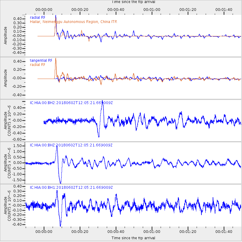
HIA Hailar, Neimenggu Autonomous Region, China - Earthquake Result Viewer
*The percent match for this event was below the threshold and hence no stack was calculated.
| Earthquake location: |
Samoa Islands Region |
| Earthquake latitude/longitude: |
-14.8/-173.1 |
| Earthquake time(UTC): |
2018/06/02 (153) 11:53:06 GMT |
| Earthquake Depth: |
50 km |
| Earthquake Magnitude: |
5.6 mb |
| Earthquake Catalog/Contributor: |
NEIC PDE/us |
|
| Network: |
IC New China Digital Seismograph Network |
| Station: |
HIA Hailar, Neimenggu Autonomous Region, China |
| Lat/Lon: |
49.27 N/119.74 E |
| Elevation: |
620 m |
|
| Distance: |
86.9 deg |
| Az: |
322.807 deg |
| Baz: |
116.779 deg |
| Ray Param: |
$rayparam |
*The percent match for this event was below the threshold and hence was not used in the summary stack. |
|
| Radial Match: |
94.88366 % |
| Radial Bump: |
400 |
| Transverse Match: |
78.88559 % |
| Transverse Bump: |
400 |
| SOD ConfigId: |
2973751 |
| Insert Time: |
2018-10-09 13:03:41.606 +0000 |
| GWidth: |
2.5 |
| Max Bumps: |
400 |
| Tol: |
0.001 |
|
Signal To Noise
| Channel | StoN | STA | LTA |
| IC:HIA:00:BHZ:20180602T12:05:21.669009Z | 1.0330087 | 4.764245E-8 | 4.6120086E-8 |
| IC:HIA:00:BH1:20180602T12:05:21.669009Z | 0.8617201 | 3.953572E-8 | 4.588E-8 |
| IC:HIA:00:BH2:20180602T12:05:21.669009Z | 0.98857945 | 4.2225363E-8 | 4.2713168E-8 |
| Arrivals |
| Ps | |
| PpPs | |
| PsPs/PpSs | |


