You are here: Home > Network List > IC - New China Digital Seismograph Network Stations List
> Station HIA Hailar, Neimenggu Autonomous Region, China > Earthquake Result Viewer
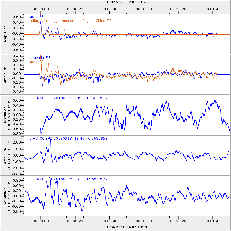
HIA Hailar, Neimenggu Autonomous Region, China - Earthquake Result Viewer
*The percent match for this event was below the threshold and hence no stack was calculated.
| Earthquake location: |
Minahassa Peninsula, Sulawesi |
| Earthquake latitude/longitude: |
0.1/119.7 |
| Earthquake time(UTC): |
2018/09/28 (271) 13:35:30 GMT |
| Earthquake Depth: |
10 km |
| Earthquake Magnitude: |
5.7 Ms_20 |
| Earthquake Catalog/Contributor: |
NEIC PDE/us |
|
| Network: |
IC New China Digital Seismograph Network |
| Station: |
HIA Hailar, Neimenggu Autonomous Region, China |
| Lat/Lon: |
49.27 N/119.74 E |
| Elevation: |
620 m |
|
| Distance: |
49.0 deg |
| Az: |
0.051 deg |
| Baz: |
180.078 deg |
| Ray Param: |
$rayparam |
*The percent match for this event was below the threshold and hence was not used in the summary stack. |
|
| Radial Match: |
67.10667 % |
| Radial Bump: |
400 |
| Transverse Match: |
71.003265 % |
| Transverse Bump: |
355 |
| SOD ConfigId: |
3045211 |
| Insert Time: |
2018-10-12 13:47:05.418 +0000 |
| GWidth: |
2.5 |
| Max Bumps: |
400 |
| Tol: |
0.001 |
|
Signal To Noise
| Channel | StoN | STA | LTA |
| IC:HIA:00:BHZ:20180928T13:43:46.568995Z | 3.1233816 | 8.656803E-7 | 2.7716123E-7 |
| IC:HIA:00:BH1:20180928T13:43:46.568995Z | 1.2391142 | 5.3150535E-7 | 4.2893976E-7 |
| IC:HIA:00:BH2:20180928T13:43:46.568995Z | 1.0014415 | 2.3257701E-7 | 2.3224224E-7 |
| Arrivals |
| Ps | |
| PpPs | |
| PsPs/PpSs | |


