You are here: Home > Network List > IC - New China Digital Seismograph Network Stations List
> Station HIA Hailar, Neimenggu Autonomous Region, China > Earthquake Result Viewer
HIA Hailar, Neimenggu Autonomous Region, China - Earthquake Result Viewer
| Earthquake location: |
Kermadec Islands Region |
| Earthquake latitude/longitude: |
-30.2/-175.9 |
| Earthquake time(UTC): |
2023/03/16 (075) 00:55:58 GMT |
| Earthquake Depth: |
10 km |
| Earthquake Magnitude: |
7.1 Mi |
| Earthquake Catalog/Contributor: |
NEIC PDE/pt |
|
| Network: |
IC New China Digital Seismograph Network |
| Station: |
HIA Hailar, Neimenggu Autonomous Region, China |
| Lat/Lon: |
49.27 N/119.74 E |
| Elevation: |
620 m |
|
| Distance: |
97.7 deg |
| Az: |
323.409 deg |
| Baz: |
128.036 deg |
| Ray Param: |
0.04014112 |
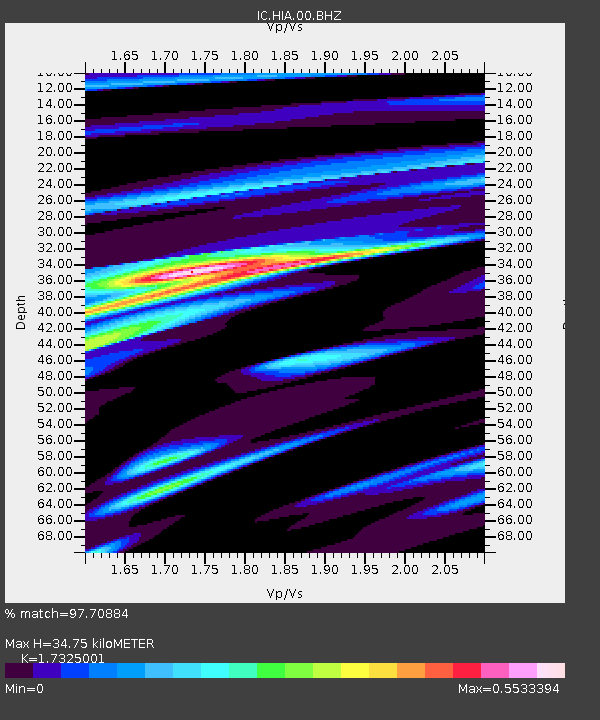
| Estimated Moho Depth: |
34.75 km |
| Estimated Crust Vp/Vs: |
1.73 |
| Assumed Crust Vp: |
6.577 km/s |
| Estimated Crust Vs: |
3.796 km/s |
| Estimated Crust Poisson's Ratio: |
0.25 |
|
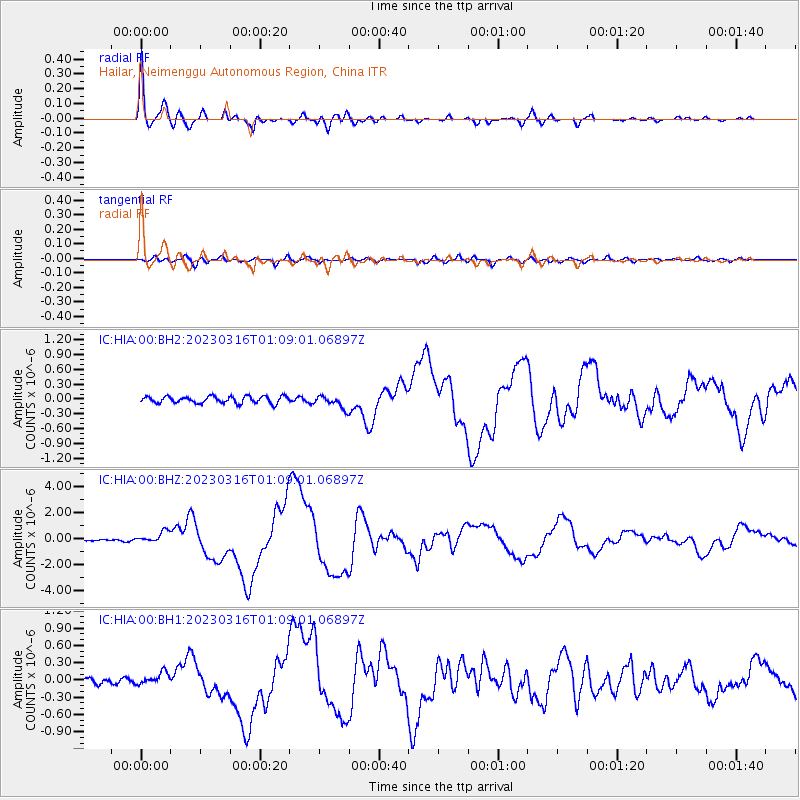
| Radial Match: |
97.70884 % |
| Radial Bump: |
352 |
| Transverse Match: |
78.54445 % |
| Transverse Bump: |
400 |
| SOD ConfigId: |
30536071 |
| Insert Time: |
2023-03-30 01:08:45.373 +0000 |
| GWidth: |
2.5 |
| Max Bumps: |
400 |
| Tol: |
0.001 |
|
Signal To Noise
| Channel | StoN | STA | LTA |
| IC:HIA:00:BHZ:20230316T01:09:01.06897Z | 5.6383924 | 4.4552135E-7 | 7.901567E-8 |
| IC:HIA:00:BH1:20230316T01:09:01.06897Z | 2.6426442 | 1.06400755E-7 | 4.026299E-8 |
| IC:HIA:00:BH2:20230316T01:09:01.06897Z | 1.8467491 | 1.274384E-7 | 6.900688E-8 |
| Arrivals |
| Ps | 4.0 SECOND |
| PpPs | 14 SECOND |
| PsPs/PpSs | 18 SECOND |


