You are here: Home > Network List > XA97 - Anatomy of an Archean Craton, South Africa Stations List
> Station SA16 XA.SA16 > Earthquake Result Viewer
SA16 XA.SA16 - Earthquake Result Viewer

| Earthquake location: |
Northern Peru |
| Earthquake latitude/longitude: |
-4.4/-76.7 |
| Earthquake time(UTC): |
1997/10/28 (301) 06:15:17 GMT |
| Earthquake Depth: |
112 km |
| Earthquake Magnitude: |
6.6 MB, 6.3 MS, 7.2 UNKNOWN, 6.6 ME |
| Earthquake Catalog/Contributor: |
WHDF/NEIC |
|
| Network: |
XA Anatomy of an Archean Craton, South Africa |
| Station: |
SA16 XA.SA16 |
| Lat/Lon: |
28.95 S/22.20 E |
| Elevation: |
1026 m |
|
| Distance: |
95.6 deg |
| Az: |
119.525 deg |
| Baz: |
261.89 deg |
| Ray Param: |
0.040645752 |
| Estimated Moho Depth: |
21.75 km |
| Estimated Crust Vp/Vs: |
1.87 |
| Assumed Crust Vp: |
6.612 km/s |
| Estimated Crust Vs: |
3.541 km/s |
| Estimated Crust Poisson's Ratio: |
0.30 |
|
| Radial Match: |
83.90568 % |
| Radial Bump: |
400 |
| Transverse Match: |
61.96747 % |
| Transverse Bump: |
340 |
| SOD ConfigId: |
6273 |
| Insert Time: |
2010-02-26 18:03:32.569 +0000 |
| GWidth: |
2.5 |
| Max Bumps: |
400 |
| Tol: |
0.001 |
|
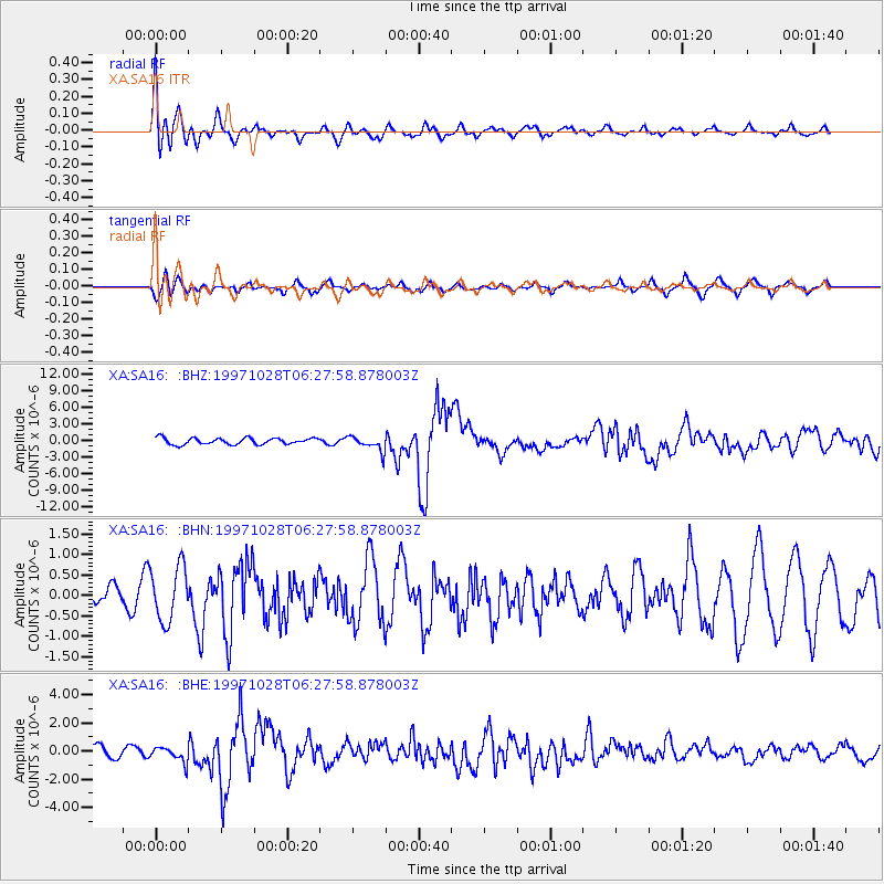
Signal To Noise
| Channel | StoN | STA | LTA |
| XA:SA16: :BHN:19971028T06:27:58.878003Z | 1.7065078 | 6.691832E-7 | 3.92136E-7 |
| XA:SA16: :BHE:19971028T06:27:58.878003Z | 1.2702761 | 5.319207E-7 | 4.187442E-7 |
| XA:SA16: :BHZ:19971028T06:27:58.878003Z | 2.3397377 | 1.3706764E-6 | 5.858248E-7 |
| Arrivals |
| Ps | 2.9 SECOND |
| PpPs | 9.2 SECOND |
| PsPs/PpSs | 12 SECOND |


