
Station XA SA16 - XA.SA16
Network: XA97 - Anatomy of an Archean Craton, South Africa
Nearby stations (2 deg radius)
| Station | Name | (Lat, Lon) | Start / End | Elevation |
| SA16 | XA.SA16 | (-28.95, 22.20) | 1997-04-22 / 1999-12-31 | 1026 m |
| Crust2 Type: | I7,late Proter., 1 km seds. |
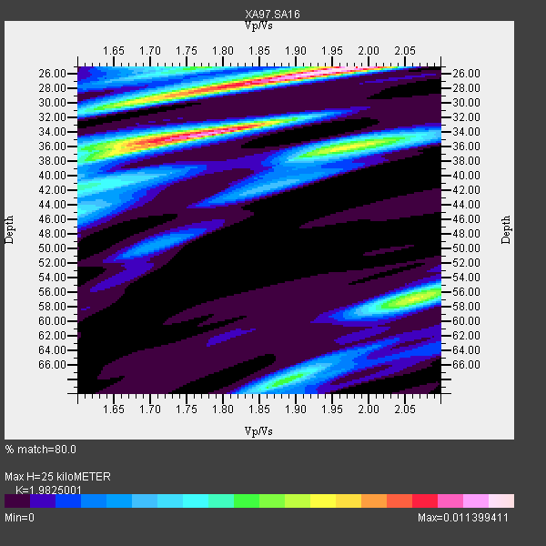
| Thickness Estimate: | 25 km |
| Thickness StdDev: | 11 km |
| Vp/Vs Estimate: | 1.98 |
| Vp/Vs StdDev: | 0.12 |
| Vs Estimate: | 3.335 km/s |
| Poisson's Ratio: | 0.33 |
| Peak Value: | 0.01 |
| Assumed Vp: | 6.612 km/s |
| Ps Weight: | 0.33333334 |
| PpPs Weight: | 0.33333334 |
| PsPs Weight: | 0.33333328 |
| Residual Complexity: | 0.827 |
| Nearby stations H: | +- |
| (2.0 deg) Vp/Vs: | +- |
5 with match > 90% ( 23.809525 %) and 9 with match > 80% ( 42.857143 %) out of 21.
Download stack as xyz text file.
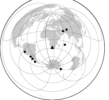
Azimuth Distribution of Events:
Prior Results for this Station
| Study | Thickness | Vp/Vs | Vp | Vs | Poissons Ratio | Extra |
| EARS | 25 km | 1.98 | 6.612 km/s | 3.335 km/s | 0.33 | |
| Crust2.0 | 42 km | 1.78 | 6.612 km/s | 3.71 km/s | 0.27 | I7,late Proter., 1 km seds. |
| Global Maxima | 25 km | 1.98 | 6.612 km/s | 3.335 km/s | 0.33 | amp=0.011399411 |
| Local Maxima 1 | 34 km | 1.77 | 6.612 km/s | 3.73 km/s | 0.27 | amp=0.0103664445 |
| Local Maxima 2 | 36 km | 1.98 | 6.612 km/s | 3.344 km/s | 0.33 | amp=0.00725627 |
| Local Maxima 3 | 57 km | 2.07 | 6.612 km/s | 3.202 km/s | 0.35 | amp=0.0069219684 |
| Local Maxima 4 | 29 km | 1.73 | 6.612 km/s | 3.833 km/s | 0.25 | amp=0.0067413272 |
| Predicted Arrivals for vertical incidence (zero ray parameter) | |
| Ps | 3.71 SECOND |
| PpPs | 11.28 SECOND |
| PsPs/PpSs | 14.99 SECOND |
Events Processed for this Station
Download zip of receiver functions as SAC
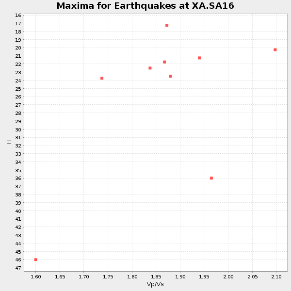
Plot maxima for each earthquake.
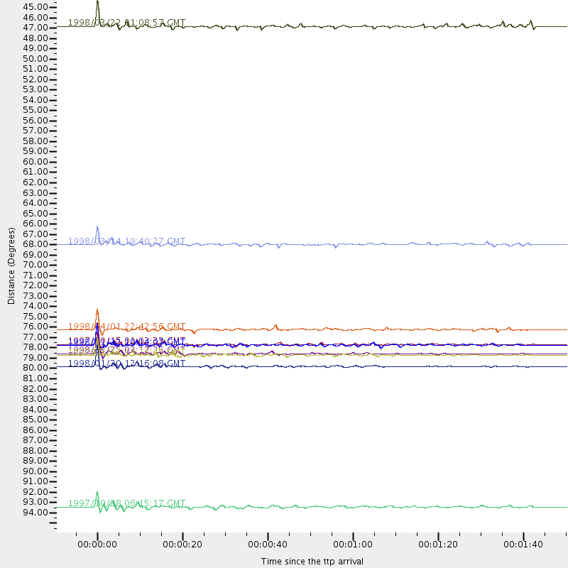
Events Used in the Stack
(9 events)| Radial Match | Distance | Baz | FERegion | Time | Lat/Lon | Depth | Magnitude |
| 99.12489 | 79.4 deg | 158.235 deg | Balleny Islands Region | 1998/03/25 03:12:25 GMT | (-62.9, 149.5) | 10 km | 6.6 MB, 8.0 MS, 8.3 UNKNOWN, 8.1 MW |
| 98.36325 | 78.4 deg | 241.13 deg | Near Coast Of Central Chile | 1997/10/15 01:03:33 GMT | (-30.9, -71.2) | 58 km | 6.8 MB, 6.8 MS, 7.3 UNKNOWN, 7.1 MW |
| 96.31891 | 80.8 deg | 247.876 deg | Near Coast Of Northern Chile | 1998/01/30 12:16:08 GMT | (-23.9, -70.2) | 42 km | 6.3 MB, 6.5 MS, 7.0 UNKNOWN, 6.7 ME |
| 94.640015 | 76.8 deg | 231.198 deg | Off Coast Of Southern Chile | 1998/04/01 22:42:56 GMT | (-40.3, -74.9) | 9.0 km | 6.2 MB, 6.0 MS, 6.7 UNKNOWN, 6.6 ME |
| 92.94984 | 78.5 deg | 241.007 deg | Near Coast Of Central Chile | 1998/01/12 10:14:07 GMT | (-31.0, -71.4) | 35 km | 5.8 MB, 6.2 MS, 6.6 UNKNOWN, 6.2 ME |
| 85.82625 | 44.6 deg | 76.252 deg | Mid-Indian Ridge | 1998/03/22 01:08:57 GMT | (-11.4, 66.2) | 10 km | 5.4 MB, 6.1 MS, 6.1 UNKNOWN, 6.1 MW |
| 85.53484 | 79.5 deg | 38.079 deg | Hindu Kush Region, Afghanistan | 1997/05/13 14:13:45 GMT | (36.4, 70.9) | 196 km | 6.1 MB, 6.5 UNKNOWN, 6.4 MW |
| 85.32574 | 67.8 deg | 32.825 deg | Northern And Central Iran | 1998/03/14 19:40:27 GMT | (30.2, 57.6) | 9.0 km | 5.9 MB, 6.9 MS, 6.6 UNKNOWN, 6.3 ME |
| 83.90568 | 95.6 deg | 261.89 deg | Northern Peru | 1997/10/28 06:15:17 GMT | (-4.4, -76.7) | 112 km | 6.6 MB, 6.3 MS, 7.2 UNKNOWN, 6.6 ME |
Losers
(12 events)| Radial Match | Distance | Baz | FERegion | Time | Lat/Lon | Depth | Magnitude | Reason |
| 78.51345 | 46.2 deg | 213.257 deg | South Sandwich Islands Region | 1997/10/05 18:04:30 GMT | (-59.7, -29.2) | 274 km | 6.0 MB, 6.3 UNKNOWN, 6.3 MW | |
| 78.2482 | 31.4 deg | 223.041 deg | Southern Mid-Atlantic Ridge | 1997/04/25 09:11:34 GMT | (-48.3, -10.0) | 10 km | 5.8 MS, 5.3 MB, 5.8 UNKNOWN, 5.7 MW | |
| 75.91668 | 79.5 deg | 242.439 deg | Near Coast Of Central Chile | 1997/07/19 12:22:57 GMT | (-29.3, -71.7) | 26 km | 5.8 MB, 5.5 MS, 5.9 UNKNOWN, 5.8 MW | |
| 73.365906 | 43.5 deg | 79.179 deg | Mid-Indian Ridge | 1997/09/25 14:20:48 GMT | (-13.8, 66.2) | 10 km | 5.3 MB, 5.7 MS, 6.0 UNKNOWN, 6.0 MW | |
| 71.534325 | 84.3 deg | 257.529 deg | Peru-Bolivia Border Region | 1997/11/28 22:53:41 GMT | (-13.7, -68.8) | 586 km | 6.4 MB, 6.6 UNKNOWN, 6.6 MW | |
| 67.05138 | 86.1 deg | 94.295 deg | Java Sea | 1997/07/11 09:55:12 GMT | (-5.7, 110.8) | 574 km | 5.6 MB | |
| 62.31272 | 78.7 deg | 245.245 deg | Northern Chile | 1997/05/17 02:10:18 GMT | (-27.2, -69.5) | 106 km | 5.5 MB, 5.6 UNKNOWN, 5.5 MW | |
| 61.3169 | 80.0 deg | 249.98 deg | Northern Chile | 1997/09/28 23:13:13 GMT | (-22.4, -68.4) | 107 km | 5.7 MB, 5.6 UNKNOWN, 5.6 MW | |
| 59.705765 | 80.9 deg | 251.963 deg | Chile-Bolivia Border Region | 1997/12/09 14:23:45 GMT | (-20.2, -68.4) | 133 km | 5.7 MB, 5.7 UNKNOWN, 5.7 MW | |
| 56.479416 | 97.1 deg | 222.225 deg | Southern Pacific Ocean | 1997/05/29 17:02:38 GMT | (-36.0, -102.5) | 10 km | 5.6 MB, 6.1 MS, 6.5 UNKNOWN, 6.4 MW | |
| 55.18043 | 45.3 deg | 300.415 deg | North Of Ascension Island | 1998/04/10 16:40:38 GMT | (-1.3, -15.7) | 10 km | 5.9 MS, 5.4 MB, 6.2 UNKNOWN, 6.1 MW | |
| 50.734543 | 90.5 deg | 257.268 deg | Central Peru | 1998/02/19 04:21:30 GMT | (-11.0, -74.4) | 33 km | 5.8 MB, 5.4 MS, 6.0 UNKNOWN, 5.9 MW |
