You are here: Home > Network List > XA97 - Anatomy of an Archean Craton, South Africa Stations List
> Station SA22 XA.SA22 > Earthquake Result Viewer
SA22 XA.SA22 - Earthquake Result Viewer
| Earthquake location: |
South Sandwich Islands Region |
| Earthquake latitude/longitude: |
-59.7/-29.2 |
| Earthquake time(UTC): |
1997/10/05 (278) 18:04:30 GMT |
| Earthquake Depth: |
274 km |
| Earthquake Magnitude: |
6.0 MB, 6.3 UNKNOWN, 6.3 MW |
| Earthquake Catalog/Contributor: |
WHDF/NEIC |
|
| Network: |
XA Anatomy of an Archean Craton, South Africa |
| Station: |
SA22 XA.SA22 |
| Lat/Lon: |
27.97 S/22.01 E |
| Elevation: |
1076 m |
|
| Distance: |
46.9 deg |
| Az: |
70.69 deg |
| Baz: |
212.709 deg |
| Ray Param: |
0.06924392 |
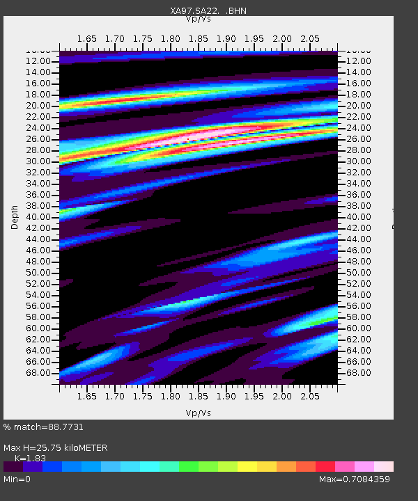
| Estimated Moho Depth: |
25.75 km |
| Estimated Crust Vp/Vs: |
1.83 |
| Assumed Crust Vp: |
6.612 km/s |
| Estimated Crust Vs: |
3.613 km/s |
| Estimated Crust Poisson's Ratio: |
0.29 |
|
| Radial Match: |
88.7731 % |
| Radial Bump: |
400 |
| Transverse Match: |
72.927605 % |
| Transverse Bump: |
400 |
| SOD ConfigId: |
6273 |
| Insert Time: |
2010-02-26 18:05:55.862 +0000 |
| GWidth: |
2.5 |
| Max Bumps: |
400 |
| Tol: |
0.001 |
|
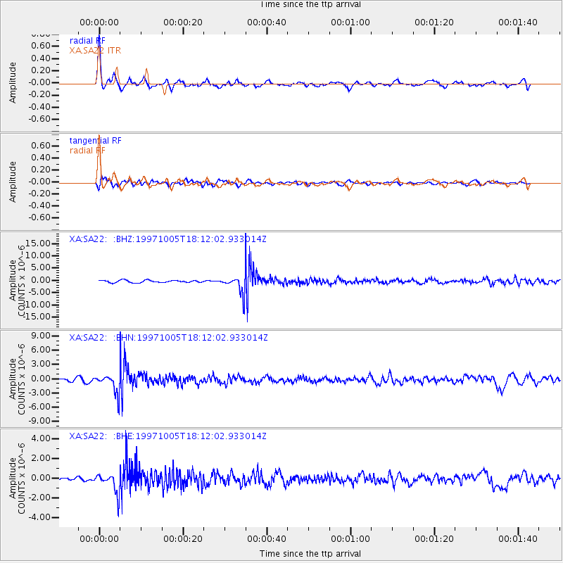
Signal To Noise
| Channel | StoN | STA | LTA |
| XA:SA22: :BHN:19971005T18:12:02.933014Z | 5.7790775 | 2.1077046E-6 | 3.6471297E-7 |
| XA:SA22: :BHE:19971005T18:12:02.933014Z | 4.380861 | 1.0211581E-6 | 2.330953E-7 |
| XA:SA22: :BHZ:19971005T18:12:02.933014Z | 8.2854805 | 3.8143783E-6 | 4.60369E-7 |
| Arrivals |
| Ps | 3.4 SECOND |
| PpPs | 10 SECOND |
| PsPs/PpSs | 14 SECOND |


