
Station XA SA22 - XA.SA22
Network: XA97 - Anatomy of an Archean Craton, South Africa
Nearby stations (2 deg radius)
| Station | Name | (Lat, Lon) | Start / End | Elevation |
| SA22 | XA.SA22 | (-27.97, 22.01) | 1997-04-21 / 1999-12-31 | 1076 m |
| Crust2 Type: | I7,late Proter., 1 km seds. |
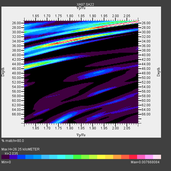
| Thickness Estimate: | 26 km |
| Thickness StdDev: | 8.0 km |
| Vp/Vs Estimate: | 2.04 |
| Vp/Vs StdDev: | 0.16 |
| Vs Estimate: | 3.249 km/s |
| Poisson's Ratio: | 0.34 |
| Peak Value: | 0.01 |
| Assumed Vp: | 6.612 km/s |
| Ps Weight: | 0.33333334 |
| PpPs Weight: | 0.33333334 |
| PsPs Weight: | 0.33333328 |
| Residual Complexity: | 0.675 |
| Nearby stations H: | +- |
| (2.0 deg) Vp/Vs: | +- |
3 with match > 90% ( 21.428572 %) and 7 with match > 80% ( 50.0 %) out of 14.
Download stack as xyz text file.
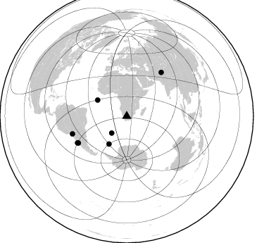
Azimuth Distribution of Events:
Prior Results for this Station
| Study | Thickness | Vp/Vs | Vp | Vs | Poissons Ratio | Extra |
| EARS | 26 km | 2.04 | 6.612 km/s | 3.249 km/s | 0.34 | |
| Crust2.0 | 42 km | 1.78 | 6.612 km/s | 3.71 km/s | 0.27 | I7,late Proter., 1 km seds. |
| Global Maxima | 26 km | 2.04 | 6.612 km/s | 3.249 km/s | 0.34 | amp=0.007668084 |
| Local Maxima 1 | 34 km | 1.78 | 6.612 km/s | 3.72 km/s | 0.27 | amp=0.0058942856 |
| Local Maxima 2 | 45 km | 1.62 | 6.612 km/s | 4.069 km/s | 0.20 | amp=0.004162687 |
| Local Maxima 3 | 30 km | 1.60 | 6.612 km/s | 4.132 km/s | 0.18 | amp=0.0035015957 |
| Local Maxima 4 | 70 km | 1.74 | 6.612 km/s | 3.794 km/s | 0.25 | amp=0.0023710814 |
| Predicted Arrivals for vertical incidence (zero ray parameter) | |
| Ps | 4.11 SECOND |
| PpPs | 12.05 SECOND |
| PsPs/PpSs | 16.16 SECOND |
Events Processed for this Station
Download zip of receiver functions as SAC
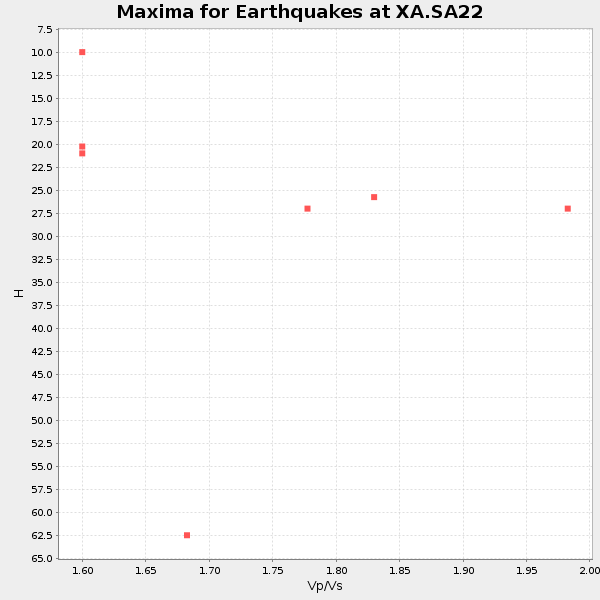
Plot maxima for each earthquake.
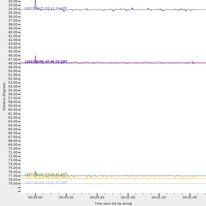
Events Used in the Stack
(7 events)| Radial Match | Distance | Baz | FERegion | Time | Lat/Lon | Depth | Magnitude |
| 99.932014 | 47.1 deg | 298.872 deg | North Of Ascension Island | 1998/03/29 07:14:58 GMT | (-0.2, -17.9) | 10 km | 5.5 MB, 5.6 MS, 6.1 UNKNOWN, 6.1 MW |
| 97.86918 | 78.7 deg | 241.028 deg | Near Coast Of Central Chile | 1997/10/15 01:03:33 GMT | (-30.9, -71.2) | 58 km | 6.8 MB, 6.8 MS, 7.3 UNKNOWN, 7.1 MW |
| 91.49326 | 78.9 deg | 38.307 deg | Hindu Kush Region, Afghanistan | 1997/05/13 14:13:45 GMT | (36.4, 70.9) | 196 km | 6.1 MB, 6.5 UNKNOWN, 6.4 MW |
| 89.45223 | 81.1 deg | 251.895 deg | Chile-Bolivia Border Region | 1997/12/09 14:23:45 GMT | (-20.2, -68.4) | 133 km | 5.7 MB, 5.7 UNKNOWN, 5.7 MW |
| 88.7731 | 46.9 deg | 212.709 deg | South Sandwich Islands Region | 1997/10/05 18:04:30 GMT | (-59.7, -29.2) | 274 km | 6.0 MB, 6.3 UNKNOWN, 6.3 MW |
| 82.09389 | 32.0 deg | 221.863 deg | Southern Mid-Atlantic Ridge | 1997/04/25 09:11:34 GMT | (-48.3, -10.0) | 10 km | 5.8 MS, 5.3 MB, 5.8 UNKNOWN, 5.7 MW |
| 80.08643 | 79.6 deg | 241.575 deg | Near Coast Of Central Chile | 1997/07/06 09:54:00 GMT | (-30.1, -71.9) | 19 km | 5.8 MB, 6.5 MS, 6.8 UNKNOWN, 6.4 ME |
Losers
(7 events)| Radial Match | Distance | Baz | FERegion | Time | Lat/Lon | Depth | Magnitude | Reason |
| 98.95664 | 87.9 deg | 48.228 deg | Xizang | 1997/11/08 10:02:52 GMT | (35.1, 87.3) | 33 km | 6.2 MB, 7.9 MS, 7.7 UNKNOWN, 7.6 MW | |
| 72.27323 | 95.0 deg | 96.941 deg | Sulawesi, Indonesia | 1997/09/28 01:38:28 GMT | (-3.8, 119.7) | 33 km | 5.6 MB, 5.5 MS, 5.9 UNKNOWN, 5.9 MW | |
| 68.26032 | 43.4 deg | 80.317 deg | Mid-Indian Ridge | 1997/09/25 14:20:48 GMT | (-13.8, 66.2) | 10 km | 5.3 MB, 5.7 MS, 6.0 UNKNOWN, 6.0 MW | |
| 68.13604 | 79.0 deg | 245.144 deg | Northern Chile | 1997/05/17 02:10:18 GMT | (-27.2, -69.5) | 106 km | 5.5 MB, 5.6 UNKNOWN, 5.5 MW | |
| 67.79123 | 86.3 deg | 94.448 deg | Java Sea | 1997/07/11 09:55:12 GMT | (-5.7, 110.8) | 574 km | 5.6 MB | |
| 57.35968 | 85.6 deg | 59.002 deg | India-Bangladesh Border Region | 1997/05/08 02:53:14 GMT | (24.9, 92.2) | 35 km | 5.6 MB, 5.6 MS, 6.0 UNKNOWN, 5.9 MW | |
| 52.4741 | 80.2 deg | 249.897 deg | Northern Chile | 1997/09/28 23:13:13 GMT | (-22.4, -68.4) | 107 km | 5.7 MB, 5.6 UNKNOWN, 5.6 MW |
