You are here: Home > Network List > IC - New China Digital Seismograph Network Stations List
> Station HIA Hailar, Neimenggu Autonomous Region, China > Earthquake Result Viewer
HIA Hailar, Neimenggu Autonomous Region, China - Earthquake Result Viewer
| Earthquake location: |
New Britain Region, P.N.G. |
| Earthquake latitude/longitude: |
-5.9/149.6 |
| Earthquake time(UTC): |
2023/04/19 (109) 09:06:03 GMT |
| Earthquake Depth: |
40 km |
| Earthquake Magnitude: |
6.3 mww |
| Earthquake Catalog/Contributor: |
NEIC PDE/us |
|
| Network: |
IC New China Digital Seismograph Network |
| Station: |
HIA Hailar, Neimenggu Autonomous Region, China |
| Lat/Lon: |
49.27 N/119.74 E |
| Elevation: |
620 m |
|
| Distance: |
60.8 deg |
| Az: |
338.052 deg |
| Baz: |
145.417 deg |
| Ray Param: |
0.06119206 |
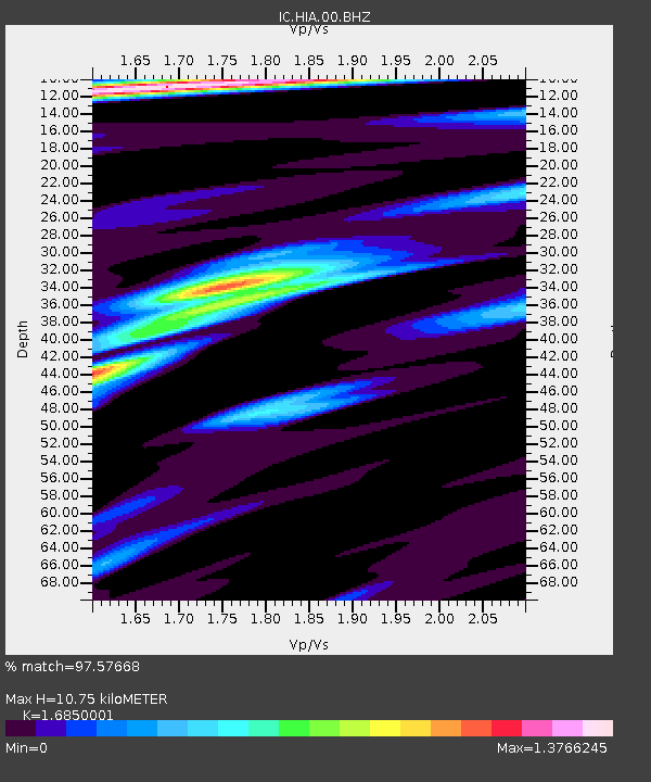
| Estimated Moho Depth: |
10.75 km |
| Estimated Crust Vp/Vs: |
1.69 |
| Assumed Crust Vp: |
6.577 km/s |
| Estimated Crust Vs: |
3.903 km/s |
| Estimated Crust Poisson's Ratio: |
0.23 |
|
| Radial Match: |
97.57668 % |
| Radial Bump: |
332 |
| Transverse Match: |
83.56806 % |
| Transverse Bump: |
400 |
| SOD ConfigId: |
30536071 |
| Insert Time: |
2023-05-03 09:20:02.322 +0000 |
| GWidth: |
2.5 |
| Max Bumps: |
400 |
| Tol: |
0.001 |
|

Signal To Noise
| Channel | StoN | STA | LTA |
| IC:HIA:00:BHZ:20230419T09:15:40.768976Z | 26.861952 | 1.625092E-6 | 6.049791E-8 |
| IC:HIA:00:BH1:20230419T09:15:40.768976Z | 10.870728 | 6.483876E-7 | 5.964528E-8 |
| IC:HIA:00:BH2:20230419T09:15:40.768976Z | 7.7371235 | 4.003119E-7 | 5.1739114E-8 |
| Arrivals |
| Ps | 1.2 SECOND |
| PpPs | 4.2 SECOND |
| PsPs/PpSs | 5.3 SECOND |


