You are here: Home > Network List > IC - New China Digital Seismograph Network Stations List
> Station HIA Hailar, Neimenggu Autonomous Region, China > Earthquake Result Viewer
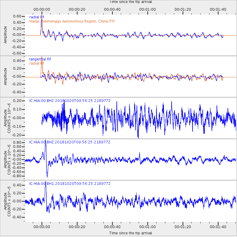
HIA Hailar, Neimenggu Autonomous Region, China - Earthquake Result Viewer
*The percent match for this event was below the threshold and hence no stack was calculated.
| Earthquake location: |
Banda Sea |
| Earthquake latitude/longitude: |
-6.5/128.3 |
| Earthquake time(UTC): |
2018/10/20 (293) 09:47:52 GMT |
| Earthquake Depth: |
352 km |
| Earthquake Magnitude: |
5.5 Mww |
| Earthquake Catalog/Contributor: |
NEIC PDE/us |
|
| Network: |
IC New China Digital Seismograph Network |
| Station: |
HIA Hailar, Neimenggu Autonomous Region, China |
| Lat/Lon: |
49.27 N/119.74 E |
| Elevation: |
620 m |
|
| Distance: |
56.0 deg |
| Az: |
353.284 deg |
| Baz: |
169.781 deg |
| Ray Param: |
$rayparam |
*The percent match for this event was below the threshold and hence was not used in the summary stack. |
|
| Radial Match: |
74.11492 % |
| Radial Bump: |
400 |
| Transverse Match: |
62.938393 % |
| Transverse Bump: |
400 |
| SOD ConfigId: |
3045211 |
| Insert Time: |
2018-11-03 09:51:04.867 +0000 |
| GWidth: |
2.5 |
| Max Bumps: |
400 |
| Tol: |
0.001 |
|
Signal To Noise
| Channel | StoN | STA | LTA |
| IC:HIA:00:BHZ:20181020T09:56:25.218977Z | 8.491617 | 4.1201216E-7 | 4.851987E-8 |
| IC:HIA:00:BH1:20181020T09:56:25.218977Z | 4.363538 | 1.9541399E-7 | 4.4783388E-8 |
| IC:HIA:00:BH2:20181020T09:56:25.218977Z | 1.2028105 | 6.554192E-8 | 5.449064E-8 |
| Arrivals |
| Ps | |
| PpPs | |
| PsPs/PpSs | |


