You are here: Home > Network List > XA97 - Anatomy of an Archean Craton, South Africa Stations List
> Station SA29 XA.SA29 > Earthquake Result Viewer
SA29 XA.SA29 - Earthquake Result Viewer
| Earthquake location: |
Balleny Islands Region |
| Earthquake latitude/longitude: |
-62.9/149.5 |
| Earthquake time(UTC): |
1998/03/25 (084) 03:12:25 GMT |
| Earthquake Depth: |
10 km |
| Earthquake Magnitude: |
6.6 MB, 8.0 MS, 8.3 UNKNOWN, 8.1 MW |
| Earthquake Catalog/Contributor: |
WHDF/NEIC |
|
| Network: |
XA Anatomy of an Archean Craton, South Africa |
| Station: |
SA29 XA.SA29 |
| Lat/Lon: |
26.93 S/23.03 E |
| Elevation: |
1120 m |
|
| Distance: |
81.0 deg |
| Az: |
226.615 deg |
| Baz: |
158.093 deg |
| Ray Param: |
0.047920004 |
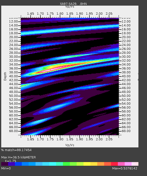
| Estimated Moho Depth: |
36.5 km |
| Estimated Crust Vp/Vs: |
1.75 |
| Assumed Crust Vp: |
6.612 km/s |
| Estimated Crust Vs: |
3.778 km/s |
| Estimated Crust Poisson's Ratio: |
0.26 |
|
| Radial Match: |
99.17454 % |
| Radial Bump: |
211 |
| Transverse Match: |
93.57076 % |
| Transverse Bump: |
400 |
| SOD ConfigId: |
6273 |
| Insert Time: |
2010-02-26 18:08:50.353 +0000 |
| GWidth: |
2.5 |
| Max Bumps: |
400 |
| Tol: |
0.001 |
|
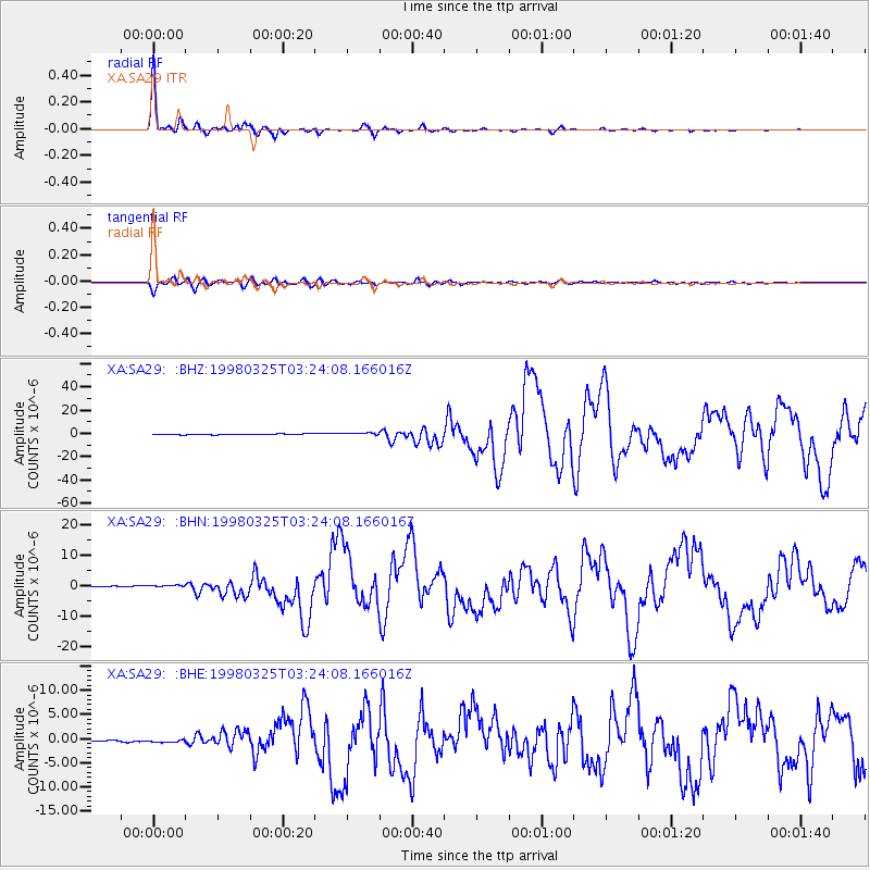
Signal To Noise
| Channel | StoN | STA | LTA |
| XA:SA29: :BHN:19980325T03:24:08.166016Z | 2.6706843 | 5.117494E-7 | 1.9161732E-7 |
| XA:SA29: :BHE:19980325T03:24:08.166016Z | 2.4295843 | 3.108758E-7 | 1.2795432E-7 |
| XA:SA29: :BHZ:19980325T03:24:08.166016Z | 3.281612 | 1.0688375E-6 | 3.2570503E-7 |
| Arrivals |
| Ps | 4.3 SECOND |
| PpPs | 15 SECOND |
| PsPs/PpSs | 19 SECOND |


