
Station XA SA29 - XA.SA29
Network: XA97 - Anatomy of an Archean Craton, South Africa
Nearby stations (2 deg radius)
| Station | Name | (Lat, Lon) | Start / End | Elevation |
| SA29 | XA.SA29 | (-26.93, 23.03) | 1997-04-23 / 1999-12-31 | 1120 m |
| Crust2 Type: | I7,late Proter., 1 km seds. |
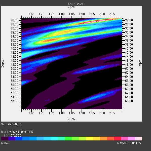
| Thickness Estimate: | 26 km |
| Thickness StdDev: | 4.4 km |
| Vp/Vs Estimate: | 1.97 |
| Vp/Vs StdDev: | 0.10 |
| Vs Estimate: | 3.352 km/s |
| Poisson's Ratio: | 0.33 |
| Peak Value: | 0.03 |
| Assumed Vp: | 6.612 km/s |
| Ps Weight: | 0.33333334 |
| PpPs Weight: | 0.33333334 |
| PsPs Weight: | 0.33333328 |
| Residual Complexity: | 0.740 |
| Nearby stations H: | +- |
| (2.0 deg) Vp/Vs: | +- |
5 with match > 90% ( 27.777779 %) and 7 with match > 80% ( 38.88889 %) out of 18.
Download stack as xyz text file.
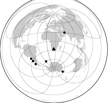
Azimuth Distribution of Events:
Prior Results for this Station
| Study | Thickness | Vp/Vs | Vp | Vs | Poissons Ratio | Extra |
| EARS | 26 km | 1.97 | 6.612 km/s | 3.352 km/s | 0.33 | |
| Crust2.0 | 42 km | 1.78 | 6.612 km/s | 3.71 km/s | 0.27 | I7,late Proter., 1 km seds. |
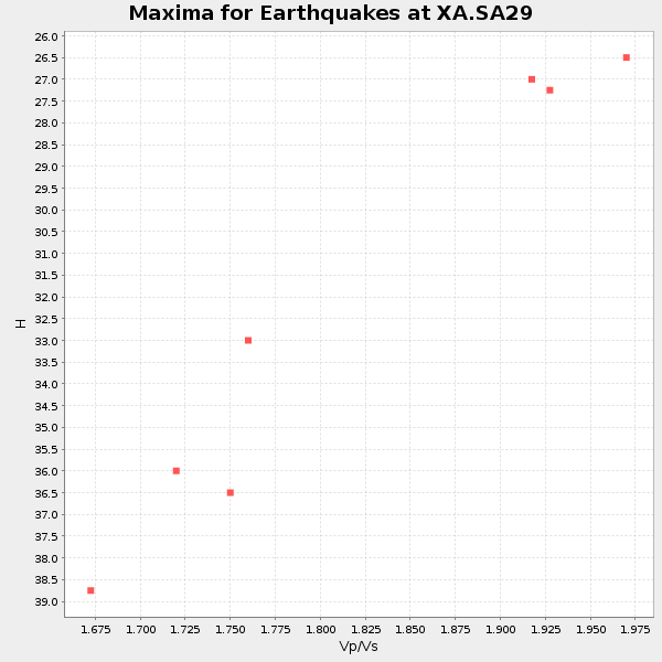
| Global Maxima | 26 km | 1.97 | 6.612 km/s | 3.352 km/s | 0.33 | amp=0.03301135 |
| Local Maxima 1 | 36 km | 1.75 | 6.612 km/s | 3.778 km/s | 0.26 | amp=0.024217274 |
| Local Maxima 2 | 32 km | 2.01 | 6.612 km/s | 3.285 km/s | 0.34 | amp=0.015805963 |
| Local Maxima 3 | 32 km | 1.80 | 6.612 km/s | 3.678 km/s | 0.28 | amp=0.013269573 |
| Local Maxima 4 | 44 km | 1.62 | 6.612 km/s | 4.088 km/s | 0.19 | amp=0.009555854 |
| Predicted Arrivals for vertical incidence (zero ray parameter) | |
| Ps | 3.90 SECOND |
| PpPs | 11.91 SECOND |
| PsPs/PpSs | 15.81 SECOND |
Events Processed for this Station
Download zip of receiver functions as SAC
Plot maxima for each earthquake.
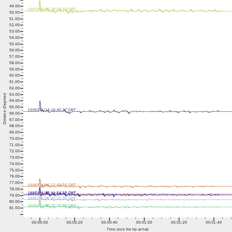
Events Used in the Stack
(7 events)| Radial Match | Distance | Baz | FERegion | Time | Lat/Lon | Depth | Magnitude |
| 99.17454 | 81.0 deg | 158.093 deg | Balleny Islands Region | 1998/03/25 03:12:25 GMT | (-62.9, 149.5) | 10 km | 6.6 MB, 8.0 MS, 8.3 UNKNOWN, 8.1 MW |
| 97.787285 | 80.0 deg | 240.472 deg | Near Coast Of Central Chile | 1997/10/15 01:03:33 GMT | (-30.9, -71.2) | 58 km | 6.8 MB, 6.8 MS, 7.3 UNKNOWN, 7.1 MW |
| 96.67284 | 82.2 deg | 247.249 deg | Near Coast Of Northern Chile | 1998/01/30 12:16:08 GMT | (-23.9, -70.2) | 42 km | 6.3 MB, 6.5 MS, 7.0 UNKNOWN, 6.7 ME |
| 94.39231 | 78.7 deg | 230.57 deg | Off Coast Of Southern Chile | 1998/04/01 22:42:56 GMT | (-40.3, -74.9) | 9.0 km | 6.2 MB, 6.0 MS, 6.7 UNKNOWN, 6.6 ME |
| 93.65442 | 80.1 deg | 240.354 deg | Near Coast Of Central Chile | 1998/01/12 10:14:07 GMT | (-31.0, -71.4) | 35 km | 5.8 MB, 6.2 MS, 6.6 UNKNOWN, 6.2 ME |
| 88.97077 | 65.7 deg | 32.632 deg | Northern And Central Iran | 1998/03/14 19:40:27 GMT | (30.2, 57.6) | 9.0 km | 5.9 MB, 6.9 MS, 6.6 UNKNOWN, 6.3 ME |
| 85.59068 | 48.3 deg | 212.434 deg | South Sandwich Islands Region | 1997/10/05 18:04:30 GMT | (-59.7, -29.2) | 274 km | 6.0 MB, 6.3 UNKNOWN, 6.3 MW |
Losers
(11 events)| Radial Match | Distance | Baz | FERegion | Time | Lat/Lon | Depth | Magnitude | Reason |
| 79.91499 | 42.4 deg | 80.779 deg | Mid-Indian Ridge | 1997/09/25 14:20:48 GMT | (-13.8, 66.2) | 10 km | 5.3 MB, 5.7 MS, 6.0 UNKNOWN, 6.0 MW | |
| 71.90747 | 79.9 deg | 158.149 deg | South Of Australia | 1998/03/25 12:17:22 GMT | (-63.6, 147.9) | 10 km | 5.8 MB, 6.1 MS, 6.5 UNKNOWN | |
| 71.13255 | 45.0 deg | 297.918 deg | North Of Ascension Island | 1998/04/10 16:40:38 GMT | (-1.3, -15.7) | 10 km | 5.9 MS, 5.4 MB, 6.2 UNKNOWN, 6.1 MW | |
| 63.80056 | 85.5 deg | 256.978 deg | Peru-Bolivia Border Region | 1997/11/28 22:53:41 GMT | (-13.7, -68.8) | 586 km | 6.4 MB, 6.6 UNKNOWN, 6.6 MW | |
| 62.163467 | 81.4 deg | 249.322 deg | Northern Chile | 1997/09/28 23:13:13 GMT | (-22.4, -68.4) | 107 km | 5.7 MB, 5.6 UNKNOWN, 5.6 MW | |
| 62.070942 | 95.9 deg | 224.207 deg | West Chile Rise | 1997/05/11 22:16:13 GMT | (-36.4, -97.7) | 10 km | 5.6 MB, 5.8 MS, 6.5 UNKNOWN, 6.4 MW | |
| 61.929657 | 34.4 deg | 245.895 deg | Southern Mid-Atlantic Ridge | 1998/01/03 06:10:08 GMT | (-35.5, -16.2) | 10 km | 5.9 MS, 5.4 MB, 6.3 UNKNOWN, 6.1 MW | |
| 61.721516 | 44.4 deg | 79.773 deg | Mid-Indian Ridge | 1998/04/09 23:26:52 GMT | (-12.2, 67.8) | 10 km | 5.5 MB, 5.4 MS, 5.9 UNKNOWN, 5.9 MW | |
| 60.560436 | 49.7 deg | 68.029 deg | Carlsberg Ridge | 1998/01/14 18:53:14 GMT | (-2.1, 68.1) | 10 km | 5.6 MS, 5.3 MB | |
| 57.54608 | 79.6 deg | 224.784 deg | Off Coast Of Southern Chile | 1998/01/19 18:23:59 GMT | (-45.0, -79.5) | 10 km | 5.5 MS, 5.4 MB, 6.2 UNKNOWN, 6.2 MW | |
| 56.318275 | 82.3 deg | 251.324 deg | Chile-Bolivia Border Region | 1997/12/09 14:23:45 GMT | (-20.2, -68.4) | 133 km | 5.7 MB, 5.7 UNKNOWN, 5.7 MW |
