You are here: Home > Network List > MP - Iraqi Seismic Observatory Stations List
> Station KIR1 Kirkuk, Iraq > Earthquake Result Viewer
KIR1 Kirkuk, Iraq - Earthquake Result Viewer
| Earthquake location: |
South Of Mariana Islands |
| Earthquake latitude/longitude: |
12.4/144.2 |
| Earthquake time(UTC): |
2023/05/12 (132) 08:02:31 GMT |
| Earthquake Depth: |
10 km |
| Earthquake Magnitude: |
5.5 Mww |
| Earthquake Catalog/Contributor: |
NEIC PDE/us |
|
| Network: |
MP Iraqi Seismic Observatory |
| Station: |
KIR1 Kirkuk, Iraq |
| Lat/Lon: |
35.39 N/44.34 E |
| Elevation: |
290 m |
|
| Distance: |
90.8 deg |
| Az: |
306.376 deg |
| Baz: |
74.298 deg |
| Ray Param: |
0.041679103 |
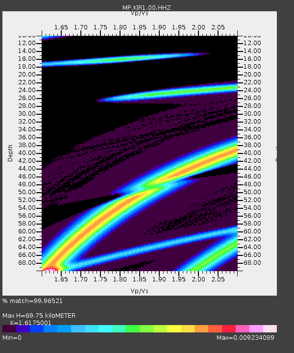
| Estimated Moho Depth: |
69.75 km |
| Estimated Crust Vp/Vs: |
1.62 |
| Assumed Crust Vp: |
6.444 km/s |
| Estimated Crust Vs: |
3.984 km/s |
| Estimated Crust Poisson's Ratio: |
0.19 |
|
| Radial Match: |
99.96521 % |
| Radial Bump: |
10 |
| Transverse Match: |
98.52725 % |
| Transverse Bump: |
162 |
| SOD ConfigId: |
30536071 |
| Insert Time: |
2023-05-26 08:15:46.471 +0000 |
| GWidth: |
2.5 |
| Max Bumps: |
400 |
| Tol: |
0.001 |
|

Signal To Noise
| Channel | StoN | STA | LTA |
| MP:KIR1:00:HHZ:20230512T08:15:03.12003Z | 1.3029479 | 8.919062E-8 | 6.845295E-8 |
| MP:KIR1:00:HHN:20230512T08:15:03.12003Z | 1.0978152 | 1.5040638E-7 | 1.3700519E-7 |
| MP:KIR1:00:HHE:20230512T08:15:03.12003Z | 1.3655555 | 2.1099139E-7 | 1.5450956E-7 |
| Arrivals |
| Ps | 6.8 SECOND |
| PpPs | 28 SECOND |
| PsPs/PpSs | 35 SECOND |


