
Station MP KIR1 - Kirkuk, Iraq
Network: MP - Iraqi Seismic Observatory
Nearby stations (2 deg radius)
| Station | Name | (Lat, Lon) | Start / End | Elevation |
| KIR1 | Kirkuk, Iraq | (35.39, 44.34) | 2018-09-17 / 2499-01-01 | 290 m |
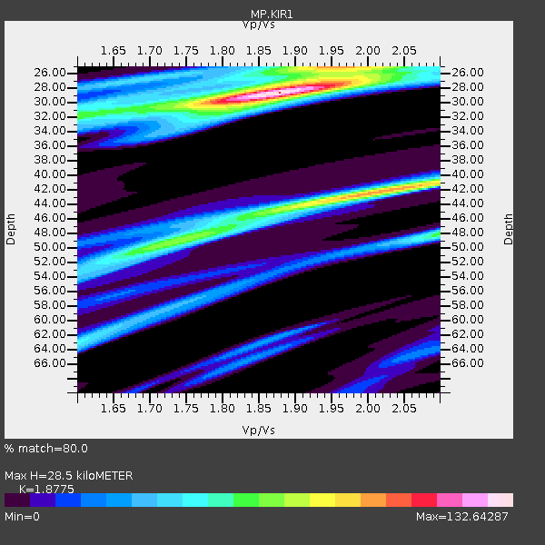
| Crust2 Type: | D6,Platform 2 km seds. |
| Thickness Estimate: | 28 km |
| Thickness StdDev: | 18 km |
| Vp/Vs Estimate: | 1.88 |
| Vp/Vs StdDev: | 0.11 |
| Vs Estimate: | 3.432 km/s |
| Poisson's Ratio: | 0.30 |
| Peak Value: | 132.64 |
| Assumed Vp: | 6.444 km/s |
| Ps Weight: | 0.33333334 |
| PpPs Weight: | 0.33333334 |
| PsPs Weight: | 0.33333328 |
| Residual Complexity: | 0.699 |
| Nearby stations H: | +- |
| (2.0 deg) Vp/Vs: | +- |
1 with match > 90% ( 3.030303 %) and 2 with match > 80% ( 6.060606 %) out of 33.
Download stack as xyz text file.
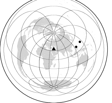
Azimuth Distribution of Events:
Prior Results for this Station
| Study | Thickness | Vp/Vs | Vp | Vs | Poissons Ratio | Extra |
| EARS | 28 km | 1.88 | 6.444 km/s | 3.432 km/s | 0.30 | |
| Crust2.0 | 41 km | 1.78 | 6.444 km/s | 3.629 km/s | 0.27 | D6,Platform 2 km seds. |
| Global Maxima | 28 km | 1.88 | 6.444 km/s | 3.432 km/s | 0.30 | amp=132.64287 |
| Local Maxima 1 | 42 km | 2.03 | 6.444 km/s | 3.182 km/s | 0.34 | amp=97.6486 |
| Local Maxima 2 | 25 km | 1.95 | 6.444 km/s | 3.313 km/s | 0.32 | amp=74.53166 |
| Local Maxima 3 | 49 km | 1.73 | 6.444 km/s | 3.719 km/s | 0.25 | amp=70.13785 |
| Local Maxima 4 | 48 km | 2.10 | 6.444 km/s | 3.072 km/s | 0.35 | amp=64.96055 |
| Predicted Arrivals for vertical incidence (zero ray parameter) | |
| Ps | 3.88 SECOND |
| PpPs | 12.73 SECOND |
| PsPs/PpSs | 16.61 SECOND |
Events Processed for this Station
Download zip of receiver functions as SAC
Plot maxima for each earthquake.
Events Used in the Stack
(2 events)| Radial Match | Distance | Baz | FERegion | Time | Lat/Lon | Depth | Magnitude |
| 99.96521 | 90.8 deg | 74.298 deg | South Of Mariana Islands | 2023/05/12 08:02:31 UTC | (12.4, 144.2) | 10 km | 5.5 Mww |
| 84.935394 | 75.6 deg | 83.981 deg | Philippine Islands Region | 2022/12/09 06:32:59 UTC | (13.2, 125.8) | 9.0 km | 5.8 mww |
Losers
(31 events)| Radial Match | Distance | Baz | FERegion | Time | Lat/Lon | Depth | Magnitude | Reason |
| 99.65317 | 69.4 deg | 74.479 deg | Southwestern Ryukyu Isl., Japan | 2023/05/11 13:33:14 UTC | (24.2, 125.3) | 25 km | 5.9 mww | |
| 82.85673 | 88.2 deg | 19.211 deg | Fox Islands, Aleutian Islands | 2022/11/21 15:09:29 UTC | (52.3, -168.1) | 0.8 km | 5.5 Mww | |
| 79.96598 | 83.2 deg | 94.234 deg | Northern Molucca Sea | 2022/07/24 06:46:40 UTC | (0.5, 126.3) | 17 km | 5.3 Mww | |
| 79.90002 | 82.1 deg | 154.424 deg | Mid-Indian Ridge | 2022/12/06 09:34:51 UTC | (-40.8, 78.6) | 10 km | 5.5 Mww | |
| 73.02287 | 57.0 deg | 111.171 deg | Off W Coast Of Northern Sumatra | 2022/09/23 20:52:59 UTC | (3.8, 96.0) | 49 km | 6.2 mww | |
| 68.28423 | 69.6 deg | 113.259 deg | Southern Sumatra, Indonesia | 2022/05/31 07:10:10 UTC | (-5.9, 104.3) | 71 km | 5.6 mb | |
| 65.80007 | 83.1 deg | 66.06 deg | Volcano Islands, Japan Region | 2022/05/01 21:57:48 UTC | (23.6, 142.7) | 51 km | 5.6 mww | |
| 62.561058 | 69.0 deg | 71.508 deg | Ryukyu Islands, Japan | 2022/05/06 13:21:08 UTC | (26.8, 126.5) | 10 km | 5.5 Mww | |
| 62.31688 | 42.7 deg | 84.881 deg | Eastern Xizang-India Border Reg. | 2022/11/10 05:01:07 UTC | (28.4, 94.4) | 21 km | 5.4 mww | |
| 61.840546 | 81.7 deg | 95.507 deg | Minahassa Peninsula, Sulawesi | 2022/08/18 07:46:27 UTC | (0.3, 124.4) | 167 km | 5.4 mww | |
| 61.745007 | 67.3 deg | 76.033 deg | Taiwan Region | 2022/05/09 06:23:03 UTC | (24.0, 122.5) | 27 km | 6.3 mww | |
| 61.373013 | 81.2 deg | 96.083 deg | Minahassa Peninsula, Sulawesi | 2022/06/07 13:24:13 UTC | (0.1, 123.7) | 132 km | 5.6 mww | |
| 59.171722 | 95.4 deg | 89.481 deg | Near North Coast Of Irian Jaya | 2022/12/08 04:58:57 UTC | (-2.7, 139.1) | 37 km | 5.5 mb | |
| 58.504086 | 71.0 deg | 69.387 deg | Ryukyu Islands, Japan | 2022/12/13 14:25:15 UTC | (27.5, 129.6) | 10 km | 5.7 mww | |
| 53.232563 | 75.6 deg | 108.219 deg | Java, Indonesia | 2023/04/14 09:55:45 UTC | (-6.0, 112.0) | 594 km | 7.0 mww | |
| 53.032436 | 77.2 deg | 59.037 deg | Southeast Of Honshu, Japan | 2023/02/05 00:03:19 UTC | (32.7, 141.8) | 10 km | 5.8 mww | |
| 52.789696 | 69.7 deg | 169.494 deg | Southwest Indian Ridge | 2023/04/15 15:01:33 UTC | (-33.8, 56.2) | 10 km | 5.9 Mww | |
| 51.8429 | 85.4 deg | 226.886 deg | Southern Mid-Atlantic Ridge | 2023/03/03 19:00:26 UTC | (-30.8, -13.4) | 10 km | 5.5 Mww | |
| 50.62244 | 71.7 deg | 72.009 deg | Ryukyu Islands, Japan | 2022/11/11 17:32:24 UTC | (25.0, 128.8) | 14 km | 5.3 Mww | |
| 50.31092 | 73.5 deg | 60.17 deg | Near S. Coast Of Honshu, Japan | 2022/11/14 08:08:26 UTC | (33.8, 137.3) | 357 km | 6.1 mww | |
| 49.884594 | 72.6 deg | 51.268 deg | Hokkaido, Japan Region | 2023/05/05 17:47:15 UTC | (41.5, 142.0) | 53 km | 5.9 Mww | |
| 46.1423 | 78.8 deg | 88.421 deg | Mindanao, Philippines | 2023/02/01 10:44:44 UTC | (7.7, 126.1) | 9.4 km | 6.0 mww | |
| 44.428318 | 76.8 deg | 29.684 deg | Komandorskiye Ostrova Region | 2022/09/20 18:23:42 UTC | (55.5, 166.3) | 10 km | 6.0 mww | |
| 43.855453 | 66.7 deg | 77.481 deg | Taiwan | 2022/09/18 05:19:18 UTC | (23.1, 121.3) | 10 km | 5.6 mww | |
| 43.81664 | 83.1 deg | 92.714 deg | Halmahera, Indonesia | 2022/05/08 21:51:41 UTC | (1.8, 127.2) | 56 km | 5.5 mww | |
| 40.87358 | 84.5 deg | 26.642 deg | Rat Islands, Aleutian Islands | 2022/12/14 18:40:26 UTC | (51.6, 178.6) | 73 km | 6.3 Mww | |
| 40.411163 | 71.8 deg | 113.326 deg | Java, Indonesia | 2023/02/07 00:35:51 UTC | (-7.3, 105.9) | 58 km | 5.5 mb | |
| 39.89703 | 78.6 deg | 152.858 deg | Mid-Indian Ridge | 2022/09/19 16:42:57 UTC | (-37.0, 78.3) | 10 km | 5.9 Mww | |
| 27.721775 | 66.7 deg | 77.403 deg | Taiwan | 2022/09/18 09:39:56 UTC | (23.2, 121.3) | 10 km | 5.5 mb | |
| 25.70375 | 76.5 deg | 42.819 deg | Kuril Islands | 2022/04/24 01:35:01 UTC | (46.0, 152.8) | 20 km | 5.7 Mww | |
| 23.680368 | 80.4 deg | 88.796 deg | Philippine Islands Region | 2022/05/04 21:41:08 UTC | (6.6, 127.1) | 35 km | 5.6 Mww |

