You are here: Home > Network List > IC - New China Digital Seismograph Network Stations List
> Station HIA Hailar, Neimenggu Province, China > Earthquake Result Viewer
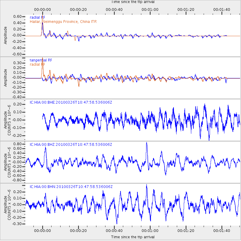
HIA Hailar, Neimenggu Province, China - Earthquake Result Viewer
*The percent match for this event was below the threshold and hence no stack was calculated.
| Earthquake location: |
Banda Sea |
| Earthquake latitude/longitude: |
-6.3/130.3 |
| Earthquake time(UTC): |
2010/03/26 (085) 10:39:02 GMT |
| Earthquake Depth: |
124 km |
| Earthquake Magnitude: |
5.7 MB, 5.7 MW, 5.7 MW |
| Earthquake Catalog/Contributor: |
WHDF/NEIC |
|
| Network: |
IC New China Digital Seismograph Network |
| Station: |
HIA Hailar, Neimenggu Province, China |
| Lat/Lon: |
49.27 N/119.74 E |
| Elevation: |
610 m |
|
| Distance: |
56.1 deg |
| Az: |
351.7 deg |
| Baz: |
167.347 deg |
| Ray Param: |
$rayparam |
*The percent match for this event was below the threshold and hence was not used in the summary stack. |
|
| Radial Match: |
71.57418 % |
| Radial Bump: |
308 |
| Transverse Match: |
60.76469 % |
| Transverse Bump: |
400 |
| SOD ConfigId: |
312771 |
| Insert Time: |
2010-06-28 15:49:55.170 +0000 |
| GWidth: |
2.5 |
| Max Bumps: |
400 |
| Tol: |
0.001 |
|
Signal To Noise
| Channel | StoN | STA | LTA |
| IC:HIA:00:BHZ:20100326T10:47:58.536006Z | 3.7583218 | 3.1801278E-7 | 8.4615635E-8 |
| IC:HIA:00:BHN:20100326T10:47:58.536006Z | 1.3505696 | 7.986789E-8 | 5.9136447E-8 |
| IC:HIA:00:BHE:20100326T10:47:58.536006Z | 1.6049123 | 7.4244454E-8 | 4.6260755E-8 |
| Arrivals |
| Ps | |
| PpPs | |
| PsPs/PpSs | |


