You are here: Home > Network List > IC - New China Digital Seismograph Network Stations List
> Station HIA Hailar, Neimenggu Autonomous Region, China > Earthquake Result Viewer
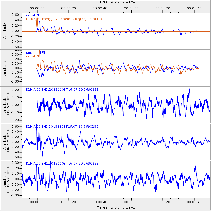
HIA Hailar, Neimenggu Autonomous Region, China - Earthquake Result Viewer
*The percent match for this event was below the threshold and hence no stack was calculated.
| Earthquake location: |
Southern Sumatra, Indonesia |
| Earthquake latitude/longitude: |
-3.8/101.8 |
| Earthquake time(UTC): |
2018/11/03 (307) 15:58:33 GMT |
| Earthquake Depth: |
51 km |
| Earthquake Magnitude: |
5.2 Mww |
| Earthquake Catalog/Contributor: |
NEIC PDE/us |
|
| Network: |
IC New China Digital Seismograph Network |
| Station: |
HIA Hailar, Neimenggu Autonomous Region, China |
| Lat/Lon: |
49.27 N/119.74 E |
| Elevation: |
620 m |
|
| Distance: |
55.1 deg |
| Az: |
14.258 deg |
| Baz: |
202.037 deg |
| Ray Param: |
$rayparam |
*The percent match for this event was below the threshold and hence was not used in the summary stack. |
|
| Radial Match: |
56.627357 % |
| Radial Bump: |
400 |
| Transverse Match: |
61.477055 % |
| Transverse Bump: |
400 |
| SOD ConfigId: |
3131071 |
| Insert Time: |
2018-11-17 16:12:35.181 +0000 |
| GWidth: |
2.5 |
| Max Bumps: |
400 |
| Tol: |
0.001 |
|
Signal To Noise
| Channel | StoN | STA | LTA |
| IC:HIA:00:BHZ:20181103T16:07:29.569028Z | 3.6208208 | 2.8470265E-7 | 7.862931E-8 |
| IC:HIA:00:BH1:20181103T16:07:29.569028Z | 1.6786287 | 1.1224972E-7 | 6.6869895E-8 |
| IC:HIA:00:BH2:20181103T16:07:29.569028Z | 1.4763038 | 7.081515E-8 | 4.796787E-8 |
| Arrivals |
| Ps | |
| PpPs | |
| PsPs/PpSs | |


