You are here: Home > Network List > XA97 - Anatomy of an Archean Craton, South Africa Stations List
> Station SA39 XA.SA39 > Earthquake Result Viewer
SA39 XA.SA39 - Earthquake Result Viewer
| Earthquake location: |
South Sandwich Islands Region |
| Earthquake latitude/longitude: |
-59.7/-29.2 |
| Earthquake time(UTC): |
1997/10/05 (278) 18:04:30 GMT |
| Earthquake Depth: |
274 km |
| Earthquake Magnitude: |
6.0 MB, 6.3 UNKNOWN, 6.3 MW |
| Earthquake Catalog/Contributor: |
WHDF/NEIC |
|
| Network: |
XA Anatomy of an Archean Craton, South Africa |
| Station: |
SA39 XA.SA39 |
| Lat/Lon: |
25.90 S/26.15 E |
| Elevation: |
1545 m |
|
| Distance: |
50.7 deg |
| Az: |
73.35 deg |
| Baz: |
212.595 deg |
| Ray Param: |
0.06687159 |
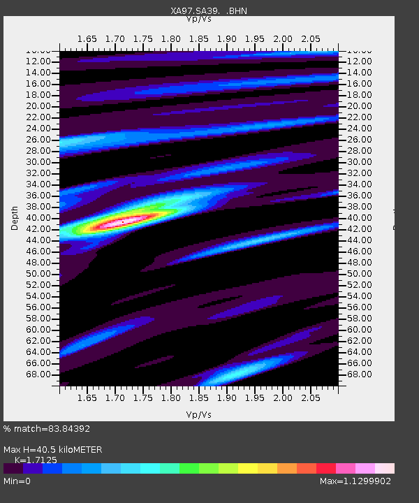
| Estimated Moho Depth: |
40.5 km |
| Estimated Crust Vp/Vs: |
1.71 |
| Assumed Crust Vp: |
6.459 km/s |
| Estimated Crust Vs: |
3.772 km/s |
| Estimated Crust Poisson's Ratio: |
0.24 |
|
| Radial Match: |
83.84392 % |
| Radial Bump: |
400 |
| Transverse Match: |
56.778717 % |
| Transverse Bump: |
400 |
| SOD ConfigId: |
6273 |
| Insert Time: |
2010-02-26 18:13:11.352 +0000 |
| GWidth: |
2.5 |
| Max Bumps: |
400 |
| Tol: |
0.001 |
|
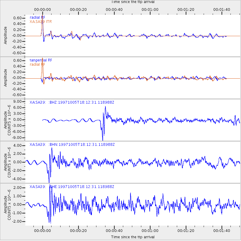
Signal To Noise
| Channel | StoN | STA | LTA |
| XA:SA39: :BHN:19971005T18:12:31.118988Z | 6.1846375 | 1.6166443E-6 | 2.6139676E-7 |
| XA:SA39: :BHE:19971005T18:12:31.118988Z | 3.0914664 | 8.7314544E-7 | 2.824373E-7 |
| XA:SA39: :BHZ:19971005T18:12:31.118988Z | 7.360036 | 3.212742E-6 | 4.3651173E-7 |
| Arrivals |
| Ps | 4.7 SECOND |
| PpPs | 16 SECOND |
| PsPs/PpSs | 21 SECOND |


