
Station XA SA39 - XA.SA39
Network: XA97 - Anatomy of an Archean Craton, South Africa
Nearby stations (2 deg radius)
| Station | Name | (Lat, Lon) | Start / End | Elevation |
| SA39 | XA.SA39 | (-25.90, 26.15) | 1997-04-22 / 1999-12-31 | 1545 m |
| Crust2 Type: | G1,Archean, no seds. |
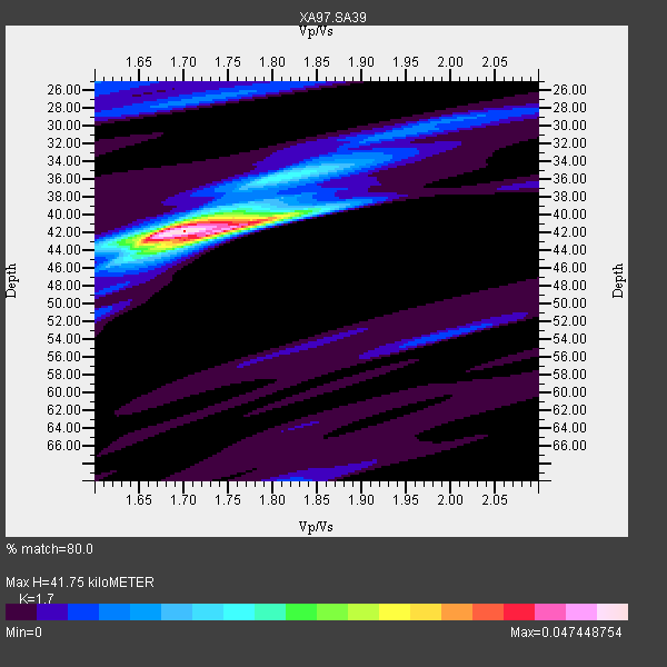
| Thickness Estimate: | 42 km |
| Thickness StdDev: | 2.6 km |
| Vp/Vs Estimate: | 1.70 |
| Vp/Vs StdDev: | 0.03 |
| Vs Estimate: | 3.8 km/s |
| Poisson's Ratio: | 0.24 |
| Peak Value: | 0.05 |
| Assumed Vp: | 6.459 km/s |
| Ps Weight: | 0.33333334 |
| PpPs Weight: | 0.33333334 |
| PsPs Weight: | 0.33333328 |
| Residual Complexity: | 0.388 |
| Nearby stations H: | +- |
| (2.0 deg) Vp/Vs: | +- |
2 with match > 90% ( 12.5 %) and 5 with match > 80% ( 31.25 %) out of 16.
Download stack as xyz text file.
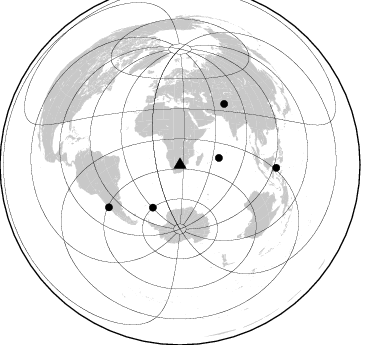
Azimuth Distribution of Events:
Prior Results for this Station
| Study | Thickness | Vp/Vs | Vp | Vs | Poissons Ratio | Extra |
| EARS | 42 km | 1.70 | 6.459 km/s | 3.8 km/s | 0.24 | |
| Crust2.0 | 37 km | 1.76 | 6.459 km/s | 3.665 km/s | 0.26 | G1,Archean, no seds. |
| Global Maxima | 42 km | 1.70 | 6.459 km/s | 3.8 km/s | 0.24 | amp=0.047448754 |
| Local Maxima 1 | 42 km | 1.73 | 6.459 km/s | 3.728 km/s | 0.25 | amp=0.020249227 |
| Local Maxima 2 | 40 km | 1.71 | 6.459 km/s | 3.772 km/s | 0.24 | amp=0.010425048 |
| Local Maxima 3 | 27 km | 1.72 | 6.459 km/s | 3.766 km/s | 0.24 | amp=0.008042447 |
| Local Maxima 4 | 35 km | 1.84 | 6.459 km/s | 3.52 km/s | 0.29 | amp=0.0077054133 |
| Predicted Arrivals for vertical incidence (zero ray parameter) | |
| Ps | 4.52 SECOND |
| PpPs | 17.45 SECOND |
| PsPs/PpSs | 21.98 SECOND |
Events Processed for this Station
Download zip of receiver functions as SAC
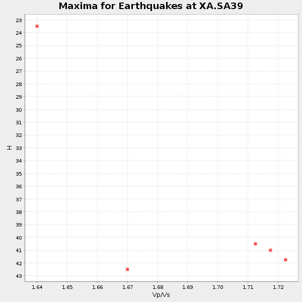
Plot maxima for each earthquake.
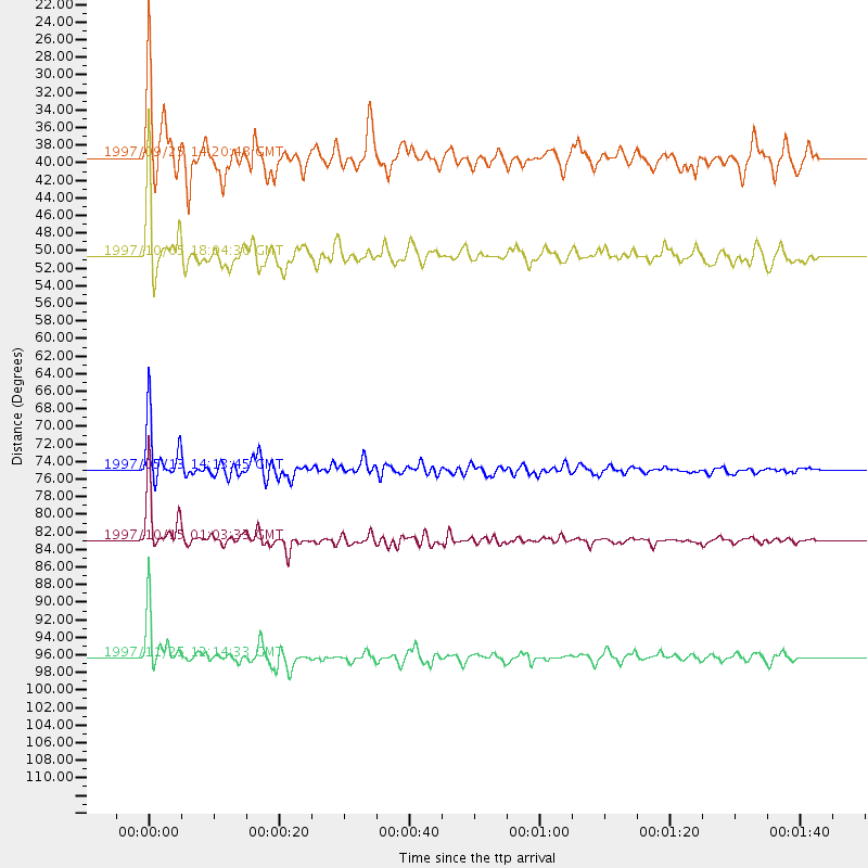
Events Used in the Stack
(5 events)| Radial Match | Distance | Baz | FERegion | Time | Lat/Lon | Depth | Magnitude |
| 98.63785 | 82.9 deg | 239.17 deg | Near Coast Of Central Chile | 1997/10/15 01:03:33 GMT | (-30.9, -71.2) | 58 km | 6.8 MB, 6.8 MS, 7.3 UNKNOWN, 7.1 MW |
| 92.44393 | 75.0 deg | 36.045 deg | Hindu Kush Region, Afghanistan | 1997/05/13 14:13:45 GMT | (36.4, 70.9) | 196 km | 6.1 MB, 6.5 UNKNOWN, 6.4 MW |
| 83.84392 | 50.7 deg | 212.595 deg | South Sandwich Islands Region | 1997/10/05 18:04:30 GMT | (-59.7, -29.2) | 274 km | 6.0 MB, 6.3 UNKNOWN, 6.3 MW |
| 83.535805 | 96.3 deg | 91.667 deg | Minahassa Peninsula, Sulawesi | 1997/11/25 12:14:33 GMT | (1.2, 122.5) | 24 km | 6.1 MB, 6.8 MS, 7.1 UNKNOWN, 6.7 ME |
| 82.89535 | 39.5 deg | 80.036 deg | Mid-Indian Ridge | 1997/09/25 14:20:48 GMT | (-13.8, 66.2) | 10 km | 5.3 MB, 5.7 MS, 6.0 UNKNOWN, 6.0 MW |
Losers
(11 events)| Radial Match | Distance | Baz | FERegion | Time | Lat/Lon | Depth | Magnitude | Reason |
| 83.41859 | 83.8 deg | 239.71 deg | Near Coast Of Central Chile | 1997/07/06 09:54:00 GMT | (-30.1, -71.9) | 19 km | 5.8 MB, 6.5 MS, 6.8 UNKNOWN, 6.4 ME | |
| 71.26727 | 83.7 deg | 152.546 deg | West Of Macquarie Island | 1997/10/17 09:55:15 GMT | (-57.5, 148.0) | 10 km | 5.2 MB, 5.9 MS, 6.2 UNKNOWN, 6.0 MW | |
| 62.69993 | 88.4 deg | 255.58 deg | Peru-Bolivia Border Region | 1997/11/28 22:53:41 GMT | (-13.7, -68.8) | 586 km | 6.4 MB, 6.6 UNKNOWN, 6.6 MW | |
| 61.468273 | 82.7 deg | 92.801 deg | Java Sea | 1997/07/11 09:55:12 GMT | (-5.7, 110.8) | 574 km | 5.6 MB | |
| 60.313602 | 83.7 deg | 239.334 deg | Near Coast Of Central Chile | 1997/07/25 06:47:02 GMT | (-30.5, -71.9) | 33 km | 5.6 MB, 5.5 MS, 6.3 UNKNOWN | |
| 60.010708 | 91.6 deg | 94.933 deg | Sulawesi, Indonesia | 1997/09/28 01:38:28 GMT | (-3.8, 119.7) | 33 km | 5.6 MB, 5.5 MS, 5.9 UNKNOWN, 5.9 MW | |
| 59.41895 | 83.2 deg | 243.239 deg | Northern Chile | 1997/05/17 02:10:18 GMT | (-27.2, -69.5) | 106 km | 5.5 MB, 5.6 UNKNOWN, 5.5 MW | |
| 58.562935 | 98.1 deg | 190.198 deg | Pacific-Antarctic Ridge | 1997/05/27 06:10:31 GMT | (-54.9, -136.2) | 10 km | 5.9 MS, 5.3 MB, 6.1 UNKNOWN, 6.0 MW | |
| 56.570526 | 82.4 deg | 248.278 deg | Jujuy Province, Argentina | 1997/07/20 10:14:22 GMT | (-23.0, -66.3) | 256 km | 5.7 MB, 6.1 UNKNOWN, 5.7 ME | |
| 54.406425 | 84.0 deg | 240.481 deg | Near Coast Of Central Chile | 1997/07/19 12:22:57 GMT | (-29.3, -71.7) | 26 km | 5.8 MB, 5.5 MS, 5.9 UNKNOWN, 5.8 MW | |
| 40.056442 | 85.3 deg | 249.94 deg | Chile-Bolivia Border Region | 1997/12/09 14:23:45 GMT | (-20.2, -68.4) | 133 km | 5.7 MB, 5.7 UNKNOWN, 5.7 MW |
