You are here: Home > Network List > XA97 - Anatomy of an Archean Craton, South Africa Stations List
> Station SA39 XA.SA39 > Earthquake Result Viewer
SA39 XA.SA39 - Earthquake Result Viewer
*The percent match for this event was below the threshold and hence no stack was calculated.
| Earthquake location: |
West Of Macquarie Island |
| Earthquake latitude/longitude: |
-57.5/148.0 |
| Earthquake time(UTC): |
1997/10/17 (290) 09:55:15 GMT |
| Earthquake Depth: |
10 km |
| Earthquake Magnitude: |
5.2 MB, 5.9 MS, 6.2 UNKNOWN, 6.0 MW |
| Earthquake Catalog/Contributor: |
WHDF/NEIC |
|
| Network: |
XA Anatomy of an Archean Craton, South Africa |
| Station: |
SA39 XA.SA39 |
| Lat/Lon: |
25.90 S/26.15 E |
| Elevation: |
1545 m |
|
| Distance: |
83.7 deg |
| Az: |
230.356 deg |
| Baz: |
152.546 deg |
| Ray Param: |
$rayparam |
*The percent match for this event was below the threshold and hence was not used in the summary stack. |
|
| Radial Match: |
71.26727 % |
| Radial Bump: |
400 |
| Transverse Match: |
62.194527 % |
| Transverse Bump: |
400 |
| SOD ConfigId: |
4480 |
| Insert Time: |
2010-02-26 18:13:22.822 +0000 |
| GWidth: |
2.5 |
| Max Bumps: |
400 |
| Tol: |
0.001 |
|
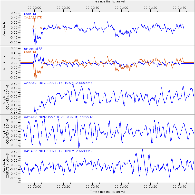
Signal To Noise
| Channel | StoN | STA | LTA |
| XA:SA39: :BHN:19971017T10:07:12.668994Z | 3.0466862 | 5.7437484E-7 | 1.8852445E-7 |
| XA:SA39: :BHE:19971017T10:07:12.668994Z | 1.0697718 | 4.6744893E-7 | 4.3696136E-7 |
| XA:SA39: :BHZ:19971017T10:07:12.668994Z | 1.3216902 | 3.6756313E-7 | 2.7810083E-7 |
| Arrivals |
| Ps | |
| PpPs | |
| PsPs/PpSs | |


