You are here: Home > Network List > TA - USArray Transportable Network (new EarthScope stations) Stations List
> Station W37A Quinton, OK, USA > Earthquake Result Viewer
W37A Quinton, OK, USA - Earthquake Result Viewer
| Earthquake location: |
Northern Peru |
| Earthquake latitude/longitude: |
-5.1/-77.5 |
| Earthquake time(UTC): |
2010/05/19 (139) 04:15:44 GMT |
| Earthquake Depth: |
140 km |
| Earthquake Magnitude: |
6.0 MB, 6.0 MW, 6.0 MW |
| Earthquake Catalog/Contributor: |
WHDF/NEIC |
|
| Network: |
TA USArray Transportable Network (new EarthScope stations) |
| Station: |
W37A Quinton, OK, USA |
| Lat/Lon: |
35.14 N/95.43 W |
| Elevation: |
281 m |
|
| Distance: |
43.4 deg |
| Az: |
338.503 deg |
| Baz: |
153.551 deg |
| Ray Param: |
0.07205775 |
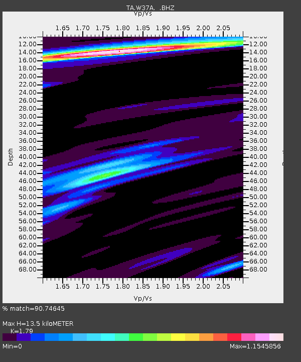
| Estimated Moho Depth: |
13.5 km |
| Estimated Crust Vp/Vs: |
1.79 |
| Assumed Crust Vp: |
6.498 km/s |
| Estimated Crust Vs: |
3.63 km/s |
| Estimated Crust Poisson's Ratio: |
0.27 |
|
| Radial Match: |
90.74645 % |
| Radial Bump: |
400 |
| Transverse Match: |
78.57458 % |
| Transverse Bump: |
400 |
| SOD ConfigId: |
314592 |
| Insert Time: |
2010-09-04 07:49:59.027 +0000 |
| GWidth: |
2.5 |
| Max Bumps: |
400 |
| Tol: |
0.001 |
|
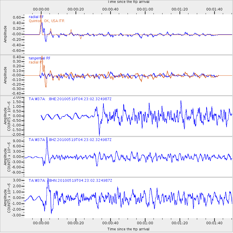
Signal To Noise
| Channel | StoN | STA | LTA |
| TA:W37A: :BHZ:20100519T04:23:02.324987Z | 18.28698 | 3.7619861E-6 | 2.0571939E-7 |
| TA:W37A: :BHN:20100519T04:23:02.324987Z | 4.8880677 | 1.4248933E-6 | 2.9150442E-7 |
| TA:W37A: :BHE:20100519T04:23:02.324987Z | 4.1272836 | 7.2354254E-7 | 1.753072E-7 |
| Arrivals |
| Ps | 1.8 SECOND |
| PpPs | 5.4 SECOND |
| PsPs/PpSs | 7.2 SECOND |


