
Station TA W37A - Quinton, OK, USA
Network: TA - USArray Transportable Network (new EarthScope stations)
Nearby stations (2 deg radius)
| Station | Name | (Lat, Lon) | Start / End | Elevation |
| W37A | Quinton, OK, USA | (35.14, -95.43) | 2010-04-23 / 2599-12-31 | 281 m |
| Crust2 Type: | D9,Platform 1 km seds. |
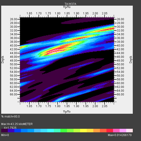
| Thickness Estimate: | 43 km |
| Thickness StdDev: | 6.3 km |
| Vp/Vs Estimate: | 1.79 |
| Vp/Vs StdDev: | 0.14 |
| Vs Estimate: | 3.625 km/s |
| Poisson's Ratio: | 0.27 |
| Peak Value: | 0.01 |
| Assumed Vp: | 6.498 km/s |
| Ps Weight: | 0.33333334 |
| PpPs Weight: | 0.33333334 |
| PsPs Weight: | 0.33333328 |
| Residual Complexity: | 0.723 |
| Nearby stations H: | +- |
| (2.0 deg) Vp/Vs: | +- |
6 with match > 90% ( 35.294117 %) and 7 with match > 80% ( 41.17647 %) out of 17.
Download stack as xyz text file.
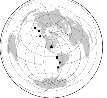
Azimuth Distribution of Events:
Prior Results for this Station
| Study | Thickness | Vp/Vs | Vp | Vs | Poissons Ratio | Extra |
| EARS | 43 km | 1.79 | 6.498 km/s | 3.625 km/s | 0.27 | |
| Crust2.0 | 41 km | 1.77 | 6.498 km/s | 3.666 km/s | 0.27 | D9,Platform 1 km seds. |
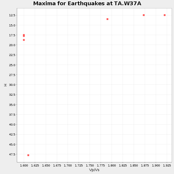
| Global Maxima | 43 km | 1.79 | 6.498 km/s | 3.625 km/s | 0.27 | amp=0.014266179 |
| Local Maxima 1 | 31 km | 2.07 | 6.498 km/s | 3.135 km/s | 0.35 | amp=0.01178572 |
| Local Maxima 2 | 41 km | 1.60 | 6.498 km/s | 4.061 km/s | 0.18 | amp=0.010230958 |
| Local Maxima 3 | 42 km | 1.80 | 6.498 km/s | 3.61 km/s | 0.28 | amp=0.008272201 |
| Local Maxima 4 | 40 km | 1.83 | 6.498 km/s | 3.555 km/s | 0.29 | amp=0.005144163 |
| Predicted Arrivals for vertical incidence (zero ray parameter) | |
| Ps | 5.28 SECOND |
| PpPs | 18.59 SECOND |
| PsPs/PpSs | 23.86 SECOND |
Events Processed for this Station
Download zip of receiver functions as SAC
Plot maxima for each earthquake.
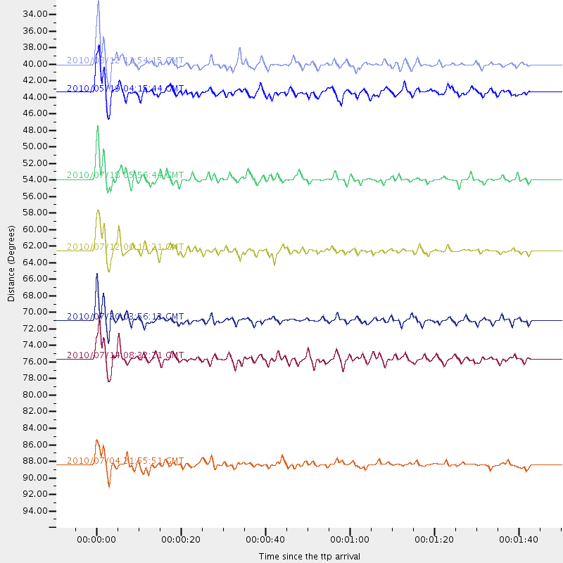
Events Used in the Stack
(7 events)| Radial Match | Distance | Baz | FERegion | Time | Lat/Lon | Depth | Magnitude |
| 97.63589 | 40.0 deg | 151.062 deg | Ecuador | 2010/08/12 11:54:15 GMT | (-1.3, -77.3) | 207 km | 6.4 MB, 7.1 MW, 7.1 MW |
| 95.51635 | 62.5 deg | 151.463 deg | Northern Chile | 2010/07/12 00:11:21 GMT | (-22.1, -68.2) | 115 km | 6.1 MB, 6.3 MW, 6.2 MW |
| 94.931816 | 53.9 deg | 313.734 deg | Fox Islands, Aleutian Islands | 2010/07/18 05:56:44 GMT | (52.9, -169.8) | 14 km | 6.3 MB, 6.7 MS, 6.6 MW, 6.6 MW |
| 92.351845 | 71.0 deg | 321.286 deg | Off East Coast Of Kamchatka | 2010/07/30 03:56:13 GMT | (52.5, 159.8) | 23 km | 6.1 MB, 6.3 MS, 6.3 MW, 6.3 MW |
| 91.814384 | 75.7 deg | 162.139 deg | Near Coast Of Central Chile | 2010/07/14 08:32:21 GMT | (-38.1, -73.3) | 22 km | 5.9 MB, 6.5 MS, 6.6 MW, 6.5 MW |
| 90.74645 | 43.4 deg | 153.551 deg | Northern Peru | 2010/05/19 04:15:44 GMT | (-5.1, -77.5) | 140 km | 6.0 MB, 6.0 MW, 6.0 MW |
| 87.96919 | 88.4 deg | 319.225 deg | Near East Coast Of Honshu, Japan | 2010/07/04 21:55:51 GMT | (39.7, 142.4) | 27 km | 6.4 MB, 6.1 MS, 6.3 MW, 6.2 MW |
Losers
(10 events)| Radial Match | Distance | Baz | FERegion | Time | Lat/Lon | Depth | Magnitude | Reason |
| 73.13169 | 64.3 deg | 154.154 deg | Northern Chile | 2010/07/17 06:07:42 GMT | (-24.7, -69.8) | 49 km | 5.7 MB, 5.5 MW, 5.5 MW | |
| 72.798195 | 53.8 deg | 313.64 deg | Fox Islands, Aleutian Islands | 2010/07/18 19:48:04 GMT | (52.8, -169.7) | 10 km | 5.6 MB, 5.6 MS, 6.0 MW, 6.0 MW | |
| 71.63512 | 53.7 deg | 313.41 deg | Fox Islands, Aleutian Islands | 2010/07/28 11:31:46 GMT | (52.7, -169.4) | 10 km | 5.6 MW, 5.2 MS, 5.2 MB, 5.1 ML | |
| 70.59741 | 75.8 deg | 162.129 deg | Near Coast Of Central Chile | 2010/07/14 15:05:50 GMT | (-38.2, -73.2) | 35 km | 5.5 MS, 5.4 MB, 5.8 MW, 5.7 MW | |
| 58.88421 | 59.5 deg | 313.69 deg | Andreanof Islands, Aleutian Is. | 2010/08/08 12:04:28 GMT | (51.3, -178.6) | 29 km | 5.7 MB, 5.0 MS, 5.4 MW, 5.8 ML | |
| 55.33083 | 70.3 deg | 322.135 deg | Near East Coast Of Kamchatka | 2010/08/15 02:10:38 GMT | (53.6, 160.1) | 40 km | 5.5 MB, 4.9 MS, 5.5 MW, 5.4 MW | |
| 54.57872 | 75.3 deg | 320.867 deg | Kuril Islands | 2010/07/25 12:57:01 GMT | (49.7, 154.6) | 130 km | 5.7 MB, 5.6 MW, 5.6 MW | |
| 52.262093 | 75.5 deg | 162.038 deg | Near Coast Of Central Chile | 2010/06/29 01:40:00 GMT | (-37.8, -73.3) | 17 km | 6.0 MB, 5.2 MS, 5.5 MW, 6.1 ML | |
| 51.772793 | 64.8 deg | 151.078 deg | Salta Province, Argentina | 2010/07/26 17:31:31 GMT | (-24.1, -66.8) | 193 km | 5.6 MW, 5.3 MB, 5.5 MW | |
| 35.572605 | 78.8 deg | 319.24 deg | Kuril Islands | 2010/05/17 22:03:47 GMT | (46.3, 152.0) | 73 km | 5.7 MB, 5.3 MW |
