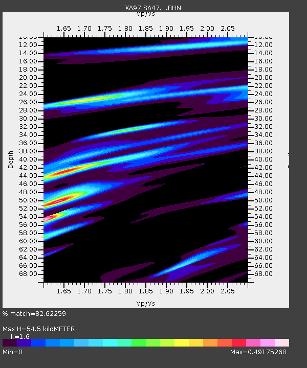
SA47 XA.SA47 - Earthquake Result Viewer

Earthquake location: South Sandwich Islands Region
Earthquake latitude/longitude: -57.8/-25.5
Earthquake time(UTC): 1997/06/02 (153) 21:24:38 GMT
Earthquake Depth: 33 km
Earthquake Magnitude: 5.9 MB, 5.8 MS, 6.1 UNKNOWN, 6.1 MW
Earthquake Catalog/Contributor: WHDF/NEIC
Network: XA Anatomy of an Archean Craton, South Africa
Station: SA47 XA.SA47
Lat/Lon: 24.85 S/28.16 E
Elevation: 1153 m
Distance: 50.1 deg
Az: 72.474 deg
Baz: 214.22 deg
Ray Param: 0.06821982
Estimated Moho Depth: 54.5 km
Estimated Crust Vp/Vs: 1.60
Assumed Crust Vp: 6.459 km/s
Estimated Crust Vs: 4.037 km/s
Estimated Crust Poisson's Ratio: 0.18
Radial Match: 82.62259 %
Radial Bump: 400
Transverse Match: 50.80939 %
Transverse Bump: 400
SOD ConfigId: 6273
Insert Time: 2010-02-26 18:16:32.398 +0000
GWidth: 2.5
Max Bumps: 400
Tol: 0.001

Signal To Noise

ChannelStoNSTALTA
XA:SA47: :BHN:19970602T21:32:59.61701Z1.58588794.5676748E-72.8802003E-7
XA:SA47: :BHE:19970602T21:32:59.61701Z1.40133313.545254E-72.5299153E-7
XA:SA47: :BHZ:19970602T21:32:59.61701Z2.66782788.004055E-73.000214E-7
Arrivals
Ps5.4 SECOND
PpPs21 SECOND
PsPs/PpSs26 SECOND