
Station XA SA47 - XA.SA47
Network: XA97 - Anatomy of an Archean Craton, South Africa
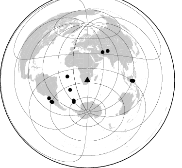
Nearby stations (2 deg radius)
| Station | Name | (Lat, Lon) | Start / End | Elevation |
| SA47 | XA.SA47 | (-24.85, 28.16) | 1997-04-20 / 1999-12-31 | 1153 m |
| Crust2 Type: | G1,Archean, no seds. |
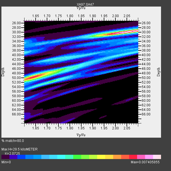
| Thickness Estimate: | 30 km |
| Thickness StdDev: | 9.8 km |
| Vp/Vs Estimate: | 2.07 |
| Vp/Vs StdDev: | 0.19 |
| Vs Estimate: | 3.117 km/s |
| Poisson's Ratio: | 0.35 |
| Peak Value: | 0.01 |
| Assumed Vp: | 6.459 km/s |
| Ps Weight: | 0.33333334 |
| PpPs Weight: | 0.33333334 |
| PsPs Weight: | 0.33333328 |
| Residual Complexity: | 0.754 |
| Nearby stations H: | +- |
| (2.0 deg) Vp/Vs: | +- |
4 with match > 90% ( 15.384615 %) and 11 with match > 80% ( 42.307693 %) out of 26.
Download stack as xyz text file.
Azimuth Distribution of Events:
Prior Results for this Station
| Study | Thickness | Vp/Vs | Vp | Vs | Poissons Ratio | Extra |
| EARS | 30 km | 2.07 | 6.459 km/s | 3.117 km/s | 0.35 | |
| Crust2.0 | 37 km | 1.76 | 6.459 km/s | 3.665 km/s | 0.26 | G1,Archean, no seds. |
| Global Maxima | 30 km | 2.07 | 6.459 km/s | 3.117 km/s | 0.35 | amp=0.007405855 |
| Local Maxima 1 | 49 km | 1.66 | 6.459 km/s | 3.891 km/s | 0.22 | amp=0.005285082 |
| Local Maxima 2 | 52 km | 1.72 | 6.459 km/s | 3.761 km/s | 0.24 | amp=0.0035599903 |
| Local Maxima 3 | 40 km | 2.02 | 6.459 km/s | 3.206 km/s | 0.34 | amp=0.0028091795 |
| Local Maxima 4 | 39 km | 1.60 | 6.459 km/s | 4.037 km/s | 0.18 | amp=0.0026012624 |
| Predicted Arrivals for vertical incidence (zero ray parameter) | |
| Ps | 4.90 SECOND |
| PpPs | 14.03 SECOND |
| PsPs/PpSs | 18.93 SECOND |
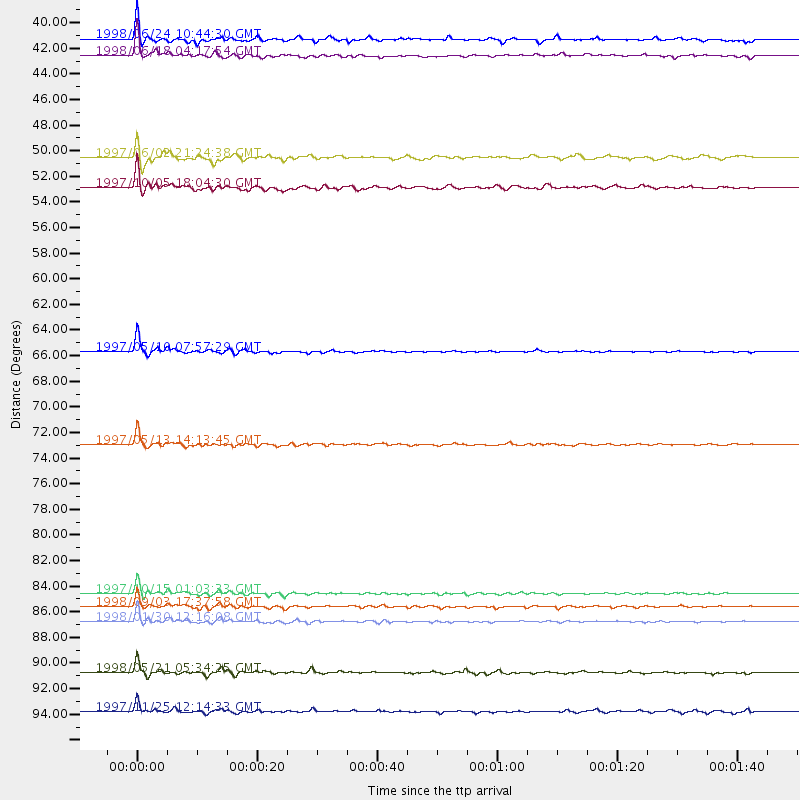
Events Processed for this Station
Download zip of receiver functions as SAC
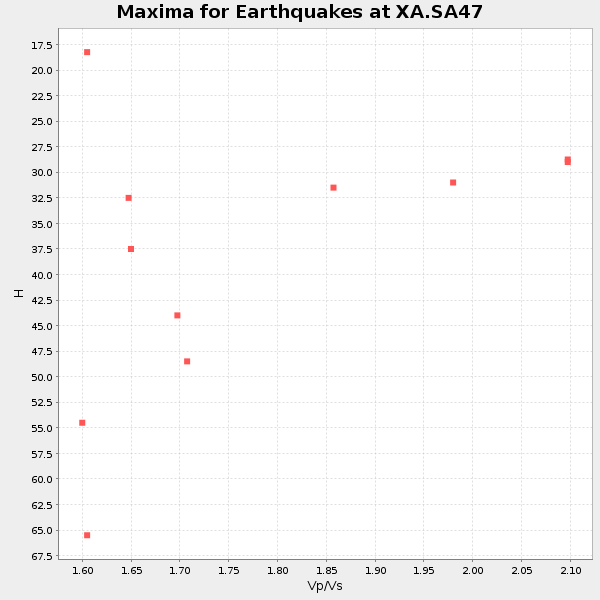
Plot maxima for each earthquake.
Events Used in the Stack
(11 events)| Radial Match | Distance | Baz | FERegion | Time | Lat/Lon | Depth | Magnitude |
| 97.328636 | 65.7 deg | 28.648 deg | Northern And Central Iran | 1997/05/10 07:57:29 GMT | (33.8, 59.8) | 10 km | 6.4 MB, 7.3 MS, 7.5 UNKNOWN, 7.2 MW |
| 96.78199 | 85.0 deg | 238.318 deg | Near Coast Of Central Chile | 1997/10/15 01:03:33 GMT | (-30.9, -71.2) | 58 km | 6.8 MB, 6.8 MS, 7.3 UNKNOWN, 7.1 MW |
| 95.486725 | 87.3 deg | 245.018 deg | Near Coast Of Northern Chile | 1998/01/30 12:16:08 GMT | (-23.9, -70.2) | 42 km | 6.3 MB, 6.5 MS, 7.0 UNKNOWN, 6.7 ME |
| 93.16303 | 73.1 deg | 34.938 deg | Hindu Kush Region, Afghanistan | 1997/05/13 14:13:45 GMT | (36.4, 70.9) | 196 km | 6.1 MB, 6.5 UNKNOWN, 6.4 MW |
| 89.21011 | 86.1 deg | 239.462 deg | Near Coast Of Central Chile | 1998/09/03 17:37:58 GMT | (-29.5, -71.7) | 27 km | 6.2 MB, 6.6 MS, 6.5 UNKNOWN, 6.4 ME |
| 87.92705 | 41.9 deg | 280.611 deg | Ascension Island Region | 1998/06/18 04:17:54 GMT | (-11.6, -13.9) | 10 km | 6.1 MS, 5.4 MB, 6.2 UNKNOWN |
| 86.748924 | 91.4 deg | 90.408 deg | Minahassa Peninsula, Sulawesi | 1998/05/21 05:34:25 GMT | (0.2, 119.6) | 33 km | 6.2 MB, 6.3 MS, 6.6 UNKNOWN, 6.6 MW |
| 83.78259 | 94.5 deg | 90.708 deg | Minahassa Peninsula, Sulawesi | 1997/11/25 12:14:33 GMT | (1.2, 122.5) | 24 km | 6.1 MB, 6.8 MS, 7.1 UNKNOWN, 6.7 ME |
| 83.07446 | 52.5 deg | 212.509 deg | South Sandwich Islands Region | 1997/10/05 18:04:30 GMT | (-59.7, -29.2) | 274 km | 6.0 MB, 6.3 UNKNOWN, 6.3 MW |
| 82.62259 | 50.1 deg | 214.22 deg | South Sandwich Islands Region | 1997/06/02 21:24:38 GMT | (-57.8, -25.5) | 33 km | 5.9 MB, 5.8 MS, 6.1 UNKNOWN, 6.1 MW |
| 81.24082 | 40.6 deg | 241.061 deg | Southern Mid-Atlantic Ridge | 1998/06/24 10:44:30 GMT | (-37.3, -17.4) | 10 km | 5.7 MB, 5.8 MS, 6.0 UNKNOWN, 5.9 MW |
Losers
(15 events)| Radial Match | Distance | Baz | FERegion | Time | Lat/Lon | Depth | Magnitude | Reason |
| 94.228264 | 73.0 deg | 34.843 deg | Hindu Kush Region, Afghanistan | 1997/12/17 05:51:29 GMT | (36.4, 70.8) | 207 km | 5.5 MB, 6.3 UNKNOWN | |
| 87.585846 | 95.9 deg | 180.574 deg | Pacific-Antarctic Ridge | 1998/08/07 01:40:16 GMT | (-59.6, -150.7) | 10 km | 5.6 MS, 4.9 MB | |
| 78.8106 | 38.0 deg | 222.036 deg | Southern Mid-Atlantic Ridge | 1997/04/25 09:11:34 GMT | (-48.3, -10.0) | 10 km | 5.8 MS, 5.3 MB, 5.8 UNKNOWN, 5.7 MW | |
| 74.76101 | 84.5 deg | 237.051 deg | Near Coast Of Central Chile | 1998/07/29 07:14:24 GMT | (-32.3, -71.3) | 51 km | 6.3 MB, 6.5 UNKNOWN, 6.5 ME | |
| 74.36341 | 85.9 deg | 238.856 deg | Near Coast Of Central Chile | 1997/07/06 09:54:00 GMT | (-30.1, -71.9) | 19 km | 5.8 MB, 6.5 MS, 6.8 UNKNOWN, 6.4 ME | |
| 73.514 | 84.4 deg | 247.388 deg | Jujuy Province, Argentina | 1997/07/20 10:14:22 GMT | (-23.0, -66.3) | 256 km | 5.7 MB, 6.1 UNKNOWN, 5.7 ME | |
| 67.69292 | 37.5 deg | 80.078 deg | Mid-Indian Ridge | 1997/09/25 14:20:48 GMT | (-13.8, 66.2) | 10 km | 5.3 MB, 5.7 MS, 6.0 UNKNOWN, 6.0 MW | |
| 66.040115 | 86.1 deg | 239.625 deg | Near Coast Of Central Chile | 1997/07/19 12:22:57 GMT | (-29.3, -71.7) | 26 km | 5.8 MB, 5.5 MS, 5.9 UNKNOWN, 5.8 MW | |
| 64.068634 | 81.8 deg | 231.784 deg | S. Chile-Argentina Border Region | 1998/12/14 16:25:24 GMT | (-38.2, -71.0) | 138 km | 6.0 UNKNOWN, 4.8 MS, 5.4 MB | |
| 62.01204 | 90.5 deg | 254.718 deg | Peru-Bolivia Border Region | 1997/11/28 22:53:41 GMT | (-13.7, -68.8) | 586 km | 6.4 MB, 6.6 UNKNOWN, 6.6 MW | |
| 57.175423 | 87.3 deg | 249.061 deg | Chile-Bolivia Border Region | 1997/12/09 14:23:45 GMT | (-20.2, -68.4) | 133 km | 5.7 MB, 5.7 UNKNOWN, 5.7 MW | |
| 54.45159 | 91.9 deg | 153.141 deg | Macquarie Island Region | 1998/06/16 09:35:11 GMT | (-53.0, 159.8) | 10 km | 5.7 MS, 4.9 MB, 6.2 UNKNOWN, 6.1 MW | |
| 49.24877 | 78.9 deg | 36.539 deg | Southern Xinjiang, China | 1998/08/27 09:03:36 GMT | (39.7, 77.3) | 33 km | 5.6 MB, 6.4 MS, 6.3 UNKNOWN, 6.3 MW | |
| 48.61155 | 69.8 deg | 14.459 deg | Eastern Caucasus | 1999/01/31 05:07:13 GMT | (43.2, 46.8) | 33 km | 5.8 MW, 5.4 MS, 5.3 MB, 5.7 MW | |
| 42.862328 | 71.1 deg | 76.212 deg | Northern Sumatra, Indonesia | 1999/02/04 19:28:00 GMT | (4.0, 95.3) | 56 km | 5.8 MB, 5.4 MS, 5.9 MW, 5.9 MW |
