You are here: Home > Network List > XA97 - Anatomy of an Archean Craton, South Africa Stations List
> Station SA47 XA.SA47 > Earthquake Result Viewer
SA47 XA.SA47 - Earthquake Result Viewer
| Earthquake location: |
South Sandwich Islands Region |
| Earthquake latitude/longitude: |
-59.7/-29.2 |
| Earthquake time(UTC): |
1997/10/05 (278) 18:04:30 GMT |
| Earthquake Depth: |
274 km |
| Earthquake Magnitude: |
6.0 MB, 6.3 UNKNOWN, 6.3 MW |
| Earthquake Catalog/Contributor: |
WHDF/NEIC |
|
| Network: |
XA Anatomy of an Archean Craton, South Africa |
| Station: |
SA47 XA.SA47 |
| Lat/Lon: |
24.85 S/28.16 E |
| Elevation: |
1153 m |
|
| Distance: |
52.5 deg |
| Az: |
74.589 deg |
| Baz: |
212.509 deg |
| Ray Param: |
0.06567144 |
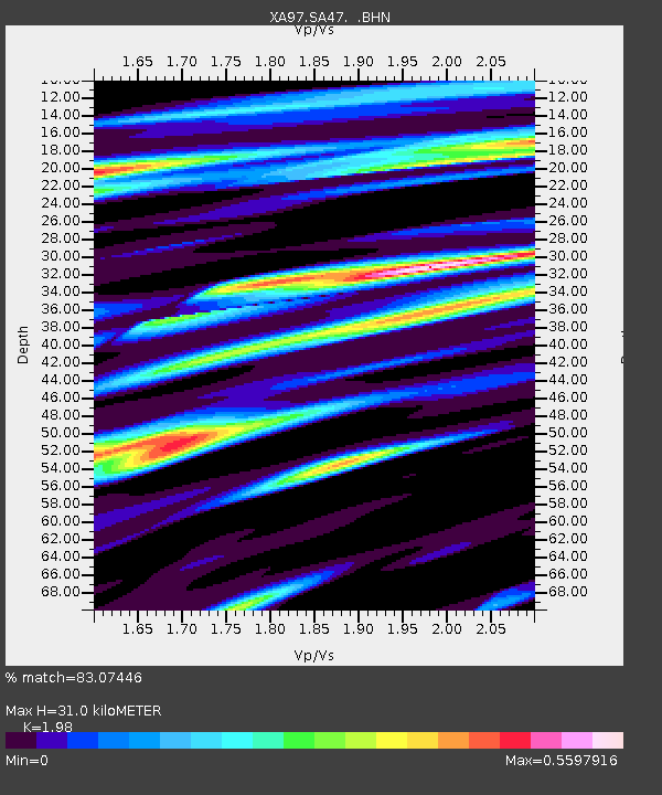
| Estimated Moho Depth: |
31.0 km |
| Estimated Crust Vp/Vs: |
1.98 |
| Assumed Crust Vp: |
6.459 km/s |
| Estimated Crust Vs: |
3.262 km/s |
| Estimated Crust Poisson's Ratio: |
0.33 |
|
| Radial Match: |
83.07446 % |
| Radial Bump: |
379 |
| Transverse Match: |
58.783062 % |
| Transverse Bump: |
400 |
| SOD ConfigId: |
6273 |
| Insert Time: |
2010-02-26 18:16:33.595 +0000 |
| GWidth: |
2.5 |
| Max Bumps: |
400 |
| Tol: |
0.001 |
|
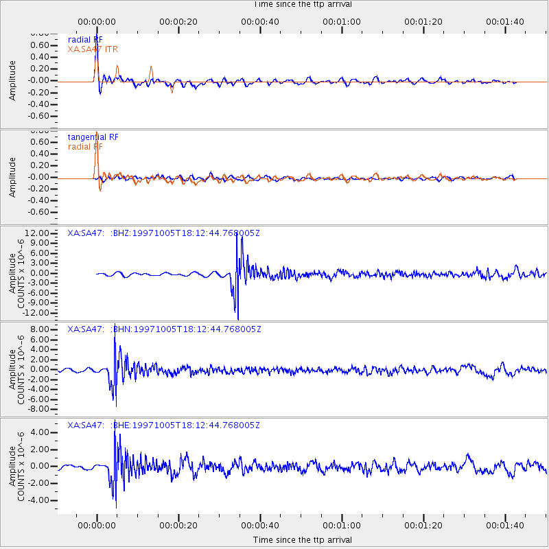
Signal To Noise
| Channel | StoN | STA | LTA |
| XA:SA47: :BHN:19971005T18:12:44.768005Z | 10.15621 | 2.7362776E-6 | 2.6941916E-7 |
| XA:SA47: :BHE:19971005T18:12:44.768005Z | 6.596977 | 1.7044586E-6 | 2.5836962E-7 |
| XA:SA47: :BHZ:19971005T18:12:44.768005Z | 11.162841 | 4.7212184E-6 | 4.2294056E-7 |
| Arrivals |
| Ps | 4.9 SECOND |
| PpPs | 14 SECOND |
| PsPs/PpSs | 19 SECOND |


