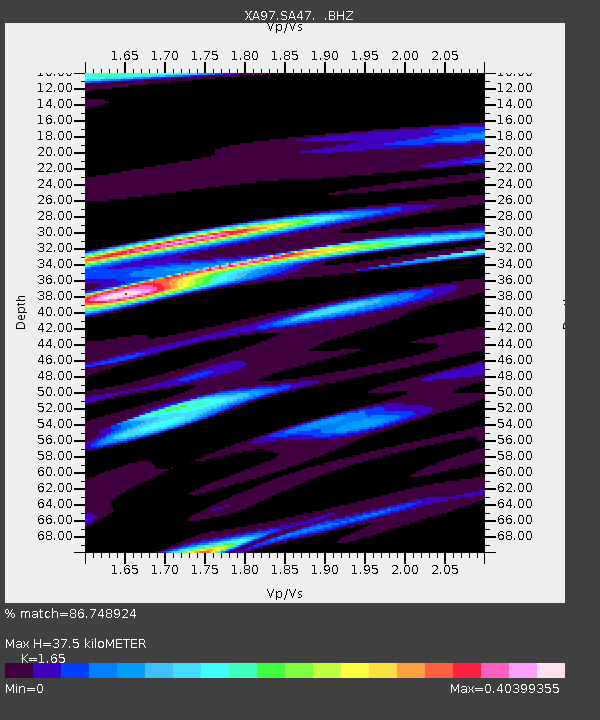
SA47 XA.SA47 - Earthquake Result Viewer
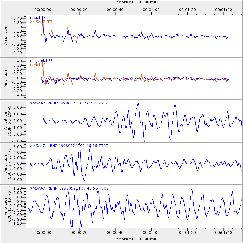
Earthquake location: Minahassa Peninsula, Sulawesi
Earthquake latitude/longitude: 0.2/119.6
Earthquake time(UTC): 1998/05/21 (141) 05:34:25 GMT
Earthquake Depth: 33 km
Earthquake Magnitude: 6.2 MB, 6.3 MS, 6.6 UNKNOWN, 6.6 MW
Earthquake Catalog/Contributor: WHDF/NEIC
Network: XA Anatomy of an Archean Craton, South Africa
Station: SA47 XA.SA47
Lat/Lon: 24.85 S/28.16 E
Elevation: 1153 m
Distance: 91.4 deg
Az: 245.297 deg
Baz: 90.408 deg
Ray Param: 0.041602366
Estimated Moho Depth: 37.5 km
Estimated Crust Vp/Vs: 1.65
Assumed Crust Vp: 6.459 km/s
Estimated Crust Vs: 3.915 km/s
Estimated Crust Poisson's Ratio: 0.21
Radial Match: 86.748924 %
Radial Bump: 305
Transverse Match: 64.458145 %
Transverse Bump: 400
SOD ConfigId: 4480
Insert Time: 2010-02-26 18:16:39.605 +0000
GWidth: 2.5
Max Bumps: 400
Tol: 0.001

Signal To Noise

ChannelStoNSTALTA
XA:SA47: :BHZ:19980521T05:46:56.750Z2.35941311.0037656E-64.254302E-7
XA:SA47: :BHN:19980521T05:46:56.750Z1.12508455.211758E-74.632326E-7
XA:SA47: :BHE:19980521T05:46:56.750Z2.0348134.3817738E-72.1534036E-7
Arrivals
Ps3.9 SECOND
PpPs15 SECOND
PsPs/PpSs19 SECOND