You are here: Home > Network List > CD - China Digital Seismograph Network Stations List
> Station BJI Baijiatuan, Beijing, China > Earthquake Result Viewer
BJI Baijiatuan, Beijing, China - Earthquake Result Viewer
| Earthquake location: |
Halmahera, Indonesia |
| Earthquake latitude/longitude: |
1.2/129.1 |
| Earthquake time(UTC): |
1992/09/26 (270) 22:15:57 GMT |
| Earthquake Depth: |
26 km |
| Earthquake Magnitude: |
5.9 MB, 6.6 MS |
| Earthquake Catalog/Contributor: |
WHDF/NEIC |
|
| Network: |
CD China Digital Seismograph Network |
| Station: |
BJI Baijiatuan, Beijing, China |
| Lat/Lon: |
40.04 N/116.18 E |
| Elevation: |
43 m |
|
| Distance: |
40.4 deg |
| Az: |
344.626 deg |
| Baz: |
159.803 deg |
| Ray Param: |
0.07438472 |
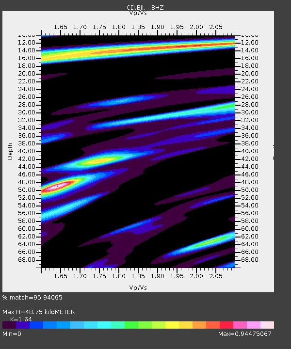
| Estimated Moho Depth: |
48.75 km |
| Estimated Crust Vp/Vs: |
1.64 |
| Assumed Crust Vp: |
6.464 km/s |
| Estimated Crust Vs: |
3.941 km/s |
| Estimated Crust Poisson's Ratio: |
0.20 |
|
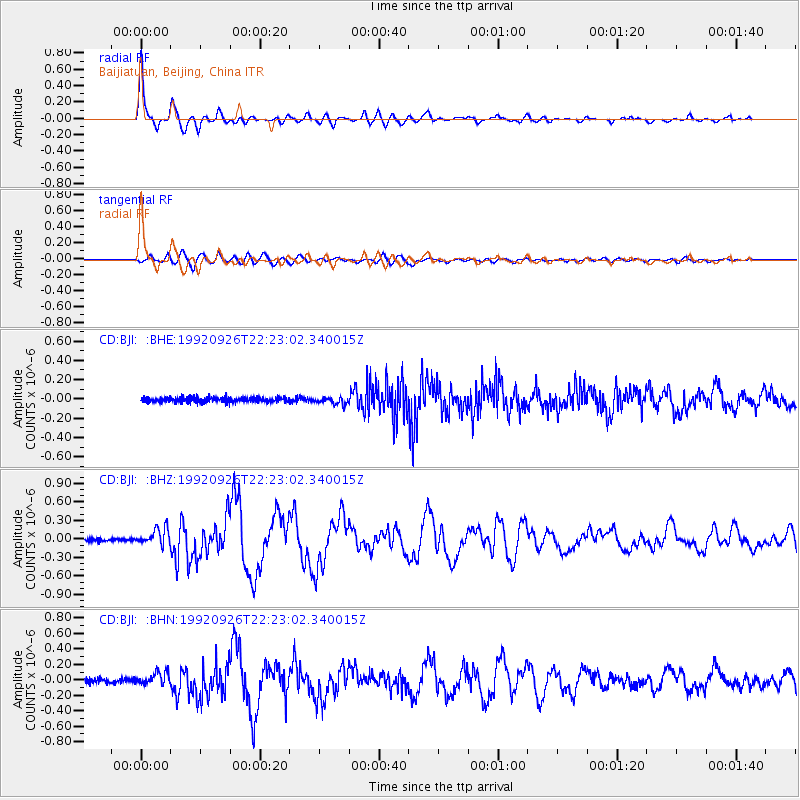
| Radial Match: |
95.94065 % |
| Radial Bump: |
387 |
| Transverse Match: |
81.41874 % |
| Transverse Bump: |
400 |
| SOD ConfigId: |
4480 |
| Insert Time: |
2010-02-26 18:19:48.338 +0000 |
| GWidth: |
2.5 |
| Max Bumps: |
400 |
| Tol: |
0.001 |
|
Signal To Noise
| Channel | StoN | STA | LTA |
| CD:BJI: :BHZ:19920926T22:23:02.340015Z | 7.1186576 | 1.3697223E-7 | 1.92413E-8 |
| CD:BJI: :BHN:19920926T22:23:02.340015Z | 2.6851516 | 8.117923E-8 | 3.0232645E-8 |
| CD:BJI: :BHE:19920926T22:23:02.340015Z | 1.4623672 | 3.5755402E-8 | 2.445036E-8 |
| Arrivals |
| Ps | 5.2 SECOND |
| PpPs | 18 SECOND |
| PsPs/PpSs | 24 SECOND |


