
Station CD BJI - Baijiatuan, Beijing, China
Network: CD - China Digital Seismograph Network
Nearby stations (2 deg radius)
| Station | Name | (Lat, Lon) | Start / End | Elevation |
| BJI | Baijiatuan, Beijing, China | (40.04, 116.18) | 1986-07-23 / 1993-06-06 | 43 m |
| BJI | Baijiatuan, Beijing, China | (40.04, 116.18) | 1993-06-09 / 1994-04-15 | 43 m |
| Crust2 Type: | G9,thin custal Archean 0.1 km seds., South American |
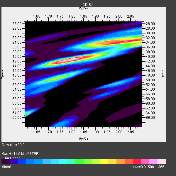
| Thickness Estimate: | 42 km |
| Thickness StdDev: | 4.6 km |
| Vp/Vs Estimate: | 1.78 |
| Vp/Vs StdDev: | 0.12 |
| Vs Estimate: | 3.636 km/s |
| Poisson's Ratio: | 0.27 |
| Peak Value: | 0.02 |
| Assumed Vp: | 6.464 km/s |
| Ps Weight: | 0.33333334 |
| PpPs Weight: | 0.33333334 |
| PsPs Weight: | 0.33333328 |
| Residual Complexity: | 0.739 |
| Nearby stations H: | +- |
| (2.0 deg) Vp/Vs: | +- |
47 with match > 90% ( 57.317074 %) and 68 with match > 80% ( 82.92683 %) out of 82.
Download stack as xyz text file.
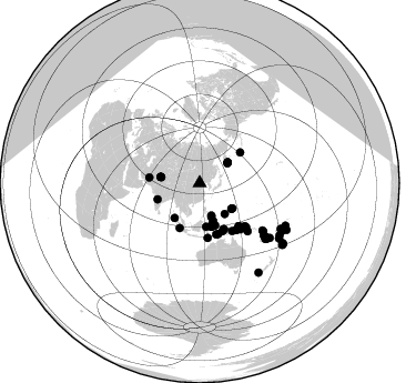
Azimuth Distribution of Events:
Prior Results for this Station
| Study | Thickness | Vp/Vs | Vp | Vs | Poissons Ratio | Extra |
| EARS | 42 km | 1.78 | 6.464 km/s | 3.636 km/s | 0.27 | |
| Crust2.0 | 31 km | 1.76 | 6.464 km/s | 3.663 km/s | 0.26 | G9,thin custal Archean 0.1 km seds., South American |
| Zandt Ammon | 31 km | 2.01 | 6.0 km/s | 2.985 km/s | 0.34 | |
| Zandt Ammon | 31 km | 2.01 | 6.0 km/s | 2.985 km/s | 0.34 | |
| Zandt Ammon | 33 km | 2.01 | 6.25 km/s | 3.109 km/s | 0.34 | |
| Zandt Ammon | 33 km | 2.01 | 6.25 km/s | 3.109 km/s | 0.34 | |
| Zandt Ammon | 34 km | 2.00 | 6.5 km/s | 3.25 km/s | 0.33 | |
| Zandt Ammon | 34 km | 2.00 | 6.5 km/s | 3.25 km/s | 0.33 | |
| Zandt Ammon | 36 km | 2.00 | 6.75 km/s | 3.375 km/s | 0.33 | |
| Zandt Ammon | 36 km | 2.00 | 6.75 km/s | 3.375 km/s | 0.33 | |
| Global Maxima | 42 km | 1.78 | 6.464 km/s | 3.636 km/s | 0.27 | amp=0.0150811365 |
| Local Maxima 1 | 33 km | 2.05 | 6.464 km/s | 3.153 km/s | 0.34 | amp=0.012591966 |
| Local Maxima 2 | 49 km | 1.74 | 6.464 km/s | 3.715 km/s | 0.25 | amp=0.008732031 |
| Local Maxima 3 | 33 km | 1.96 | 6.464 km/s | 3.298 km/s | 0.32 | amp=0.008145093 |
| Local Maxima 4 | 34 km | 2.10 | 6.464 km/s | 3.082 km/s | 0.35 | amp=0.007819455 |
| Predicted Arrivals for vertical incidence (zero ray parameter) | |
| Ps | 4.99 SECOND |
| PpPs | 17.83 SECOND |
| PsPs/PpSs | 22.83 SECOND |
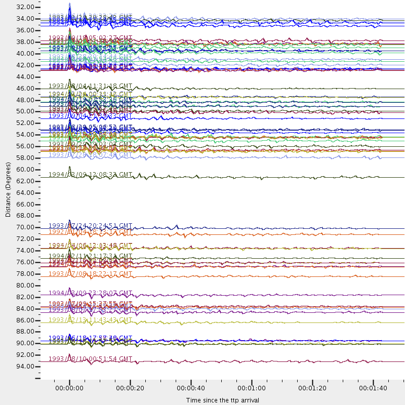
Events Processed for this Station
Download zip of receiver functions as SAC
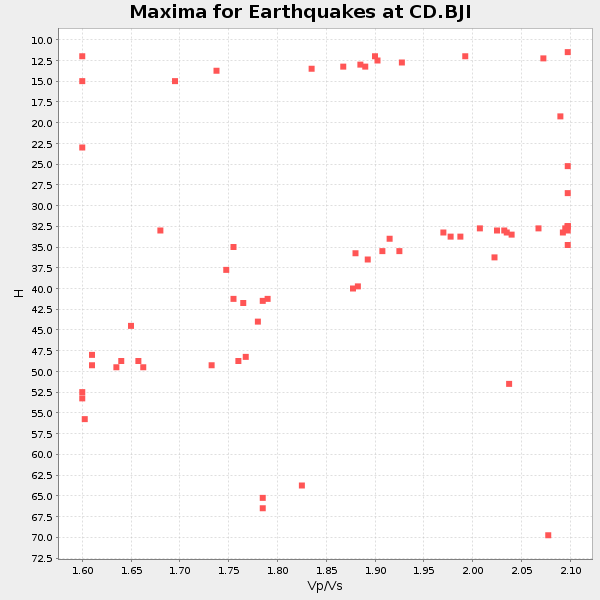
Plot maxima for each earthquake.
Events Used in the Stack
(68 events)| Radial Match | Distance | Baz | FERegion | Time | Lat/Lon | Depth | Magnitude |
| 98.18374 | 83.6 deg | 119.393 deg | Fiji Islands Region | 1994/03/09 23:28:07 GMT | (-17.8, -178.5) | 564 km | 6.6 MB, 7.6 UNKNOWN, 7.6 MW |
| 98.14231 | 46.7 deg | 152.255 deg | Irian Jaya, Indonesia | 1994/01/19 01:53:36 GMT | (-3.2, 136.0) | 33 km | 6.0 MB, 6.9 MS, 6.9 UNKNOWN |
| 98.00981 | 78.0 deg | 129.939 deg | Vanuatu Islands | 1994/02/12 17:58:25 GMT | (-20.6, 169.4) | 33 km | 6.3 MB, 7.2 MS, 7.2 UNKNOWN, 7.0 MW |
| 97.041374 | 46.6 deg | 152.277 deg | Irian Jaya Region, Indonesia | 1994/04/13 22:22:29 GMT | (-3.1, 136.0) | 20 km | 6.0 MB, 6.5 MS, 6.5 UNKNOWN, 6.5 MW |
| 96.404655 | 53.4 deg | 141.904 deg | Eastern New Guinea Reg., P.N.G. | 1993/10/13 02:06:00 GMT | (-5.9, 146.0) | 24 km | 6.4 MB, 7.1 MS, 6.7 UNKNOWN, 7.1 ML |
| 96.310234 | 85.9 deg | 123.04 deg | Fiji Islands Region | 1994/03/31 22:40:53 GMT | (-22.0, -179.6) | 591 km | 5.9 MB, 6.5 UNKNOWN, 6.5 MW |
| 96.15686 | 47.5 deg | 154.048 deg | Irian Jaya Region, Indonesia | 1993/06/12 18:26:45 GMT | (-4.4, 135.1) | 33 km | 5.8 MB, 6.1 MS, 6.2 UNKNOWN, 6.2 MW |
| 95.94065 | 40.4 deg | 159.803 deg | Halmahera, Indonesia | 1992/09/26 22:15:57 GMT | (1.2, 129.1) | 26 km | 5.9 MB, 6.6 MS |
| 95.90781 | 53.5 deg | 141.726 deg | Eastern New Guinea Reg., P.N.G. | 1993/10/16 03:05:31 GMT | (-5.9, 146.2) | 33 km | 6.2 MB, 6.4 MS, 6.5 UNKNOWN, 6.3 MW |
| 95.78604 | 44.1 deg | 204.059 deg | Southern Sumatra, Indonesia | 1993/08/04 11:31:18 GMT | (-1.6, 99.7) | 33 km | 5.9 MB, 6.4 MS, 6.2 UNKNOWN, 6.4 MW |
| 95.656525 | 31.1 deg | 159.992 deg | Philippine Islands Region | 1993/11/29 20:28:43 GMT | (10.2, 126.5) | 33 km | 5.6 MB, 5.7 MS |
| 95.57851 | 76.6 deg | 128.953 deg | Vanuatu Islands | 1994/02/11 21:17:31 GMT | (-18.8, 169.2) | 204 km | 6.3 MB, 7.0 UNKNOWN, 6.8 MW |
| 95.43256 | 40.4 deg | 164.912 deg | Northern Molucca Sea | 1993/12/09 11:38:30 GMT | (0.4, 125.9) | 33 km | 6.1 MB, 6.4 MS, 6.3 UNKNOWN, 6.6 MW |
| 95.21386 | 88.8 deg | 118.212 deg | Tonga Islands | 1993/12/13 11:43:43 GMT | (-20.5, -173.8) | 33 km | 5.6 MB, 6.0 MS |
| 95.174446 | 36.9 deg | 128.957 deg | South Of Mariana Islands | 1993/08/08 08:34:25 GMT | (13.0, 144.8) | 61 km | 7.2 MB, 8.1 MS, 8.2 UNKNOWN, 7.5 MW |
| 95.00534 | 74.6 deg | 129.135 deg | Vanuatu Islands | 1994/04/06 12:13:48 GMT | (-17.4, 167.7) | 44 km | 5.5 MB, 6.0 MS, 6.1 UNKNOWN, 6.2 MW |
| 94.78394 | 40.2 deg | 161.94 deg | Halmahera, Indonesia | 1994/01/21 02:24:31 GMT | (1.0, 127.7) | 33 km | 7.2 MS, 7.0 UNKNOWN |
| 94.61788 | 85.7 deg | 120.163 deg | Fiji Islands Region | 1993/07/09 15:37:55 GMT | (-19.8, -177.5) | 412 km | 5.9 MB, 5.9 UNKNOWN, 6.1 MW |
| 94.507454 | 86.9 deg | 124.766 deg | South Of Fiji Islands | 1993/08/07 17:53:27 GMT | (-23.9, 179.8) | 555 km | 6.0 MB, 5.9 UNKNOWN, 6.9 MW |
| 94.403496 | 31.4 deg | 53.456 deg | Near East Coast Of Kamchatka | 1993/11/13 01:18:04 GMT | (51.9, 158.7) | 34 km | 6.5 MB, 7.1 MS, 6.9 UNKNOWN |
| 94.28792 | 93.0 deg | 126.4 deg | Kermadec Islands Region | 1993/06/18 11:52:51 GMT | (-29.4, -176.7) | 21 km | 6.2 MB, 6.8 MS, 6.9 UNKNOWN, 6.8 MW |
| 94.0887 | 48.7 deg | 159.789 deg | Tanimbar Islands Reg., Indonesia | 1993/12/20 13:56:18 GMT | (-6.9, 131.3) | 33 km | 6.1 MB, 5.7 MS, 5.6 UNKNOWN |
| 94.02605 | 55.9 deg | 135.316 deg | New Britain Region, P.N.G. | 1993/05/17 16:02:55 GMT | (-5.3, 152.0) | 33 km | 5.8 MB, 6.4 MS, 6.5 UNKNOWN |
| 93.900314 | 74.6 deg | 129.07 deg | Vanuatu Islands | 1993/07/09 13:03:12 GMT | (-17.4, 167.8) | 33 km | 5.4 MB, 5.7 MS, 5.8 UNKNOWN, 6.1 MW |
| 93.83619 | 40.4 deg | 164.757 deg | Northern Molucca Sea | 1993/12/09 04:32:22 GMT | (0.5, 126.0) | 33 km | 6.3 MB, 6.7 MS, 6.7 UNKNOWN, 6.8 MW |
| 93.60811 | 77.4 deg | 130.111 deg | Loyalty Islands | 1994/02/16 22:03:12 GMT | (-20.2, 168.8) | 33 km | 5.6 MB, 5.8 MS, 5.9 UNKNOWN, 6.1 MW |
| 93.48029 | 52.1 deg | 137.815 deg | Bismarck Sea | 1993/11/05 22:37:20 GMT | (-3.2, 148.2) | 16 km | 5.6 MB, 6.2 MS, 6.1 UNKNOWN, 6.2 MW |
| 93.46628 | 72.0 deg | 127.214 deg | Vanuatu Islands | 1992/11/04 18:13:17 GMT | (-14.2, 167.5) | 33 km | 6.0 MB, 6.2 MS |
| 93.16613 | 30.8 deg | 54.689 deg | Near East Coast Of Kamchatka | 1993/06/12 20:33:26 GMT | (51.2, 157.7) | 49 km | 6.0 MB, 5.9 MS, 5.5 UNKNOWN, 6.3 MW |
| 92.96241 | 45.8 deg | 52.941 deg | Andreanof Islands, Aleutian Is. | 1994/04/05 09:35:46 GMT | (51.3, -178.1) | 33 km | 5.8 MB, 5.9 MS, 6.2 UNKNOWN, 6.0 MW |
| 92.89631 | 35.5 deg | 278.86 deg | Hindu Kush Region, Afghanistan | 1993/08/09 12:42:49 GMT | (36.4, 70.9) | 230 km | 6.3 MB, 6.9 UNKNOWN |
| 92.766365 | 92.3 deg | 125.862 deg | Kermadec Islands Region | 1993/06/18 17:57:48 GMT | (-28.5, -176.8) | 20 km | 5.9 MB, 6.7 MS, 6.6 UNKNOWN, 6.6 MW |
| 92.59131 | 40.6 deg | 249.108 deg | Southern India | 1993/09/29 22:25:48 GMT | (18.1, 76.4) | 6.0 km | 6.3 MB, 6.3 MS, 6.1 UNKNOWN, 6.1 MW |
| 92.47574 | 47.5 deg | 153.905 deg | Irian Jaya Region, Indonesia | 1994/01/04 19:32:02 GMT | (-4.3, 135.1) | 33 km | 5.7 MB, 6.1 MS, 6.0 UNKNOWN, 6.0 MW |
| 92.45158 | 35.7 deg | 140.863 deg | W. Caroline Islands, Micronesia | 1993/09/26 03:31:18 GMT | (10.0, 138.2) | 33 km | 6.1 MB, 6.0 MS, 5.9 UNKNOWN, 6.4 MW |
| 91.775566 | 51.9 deg | 145.72 deg | New Guinea, Papua New Guinea | 1993/08/20 05:06:52 GMT | (-6.0, 142.7) | 7.0 km | 6.0 MB, 6.2 MS, 6.4 UNKNOWN, 6.4 MW |
| 91.55585 | 52.6 deg | 137.499 deg | Bismarck Sea | 1993/10/02 16:02:02 GMT | (-3.5, 148.7) | 55 km | 5.1 MB, 5.9 MS |
| 91.520996 | 57.3 deg | 133.343 deg | Solomon Islands | 1993/07/28 18:07:49 GMT | (-5.6, 154.1) | 33 km | 5.5 MB, 6.0 MS, 6.1 UNKNOWN |
| 91.445366 | 56.0 deg | 133.639 deg | New Ireland Region, P.N.G. | 1993/09/06 03:56:02 GMT | (-4.7, 153.2) | 73 km | 6.0 MB, 6.6 MS, 6.7 UNKNOWN, 6.6 MW |
| 91.291695 | 32.2 deg | 161.06 deg | Mindanao, Philippines | 1994/03/30 13:29:13 GMT | (9.0, 126.3) | 56 km | 5.9 MB, 5.9 UNKNOWN |
| 91.08404 | 48.4 deg | 162.129 deg | Banda Sea | 1993/08/29 09:57:49 GMT | (-7.0, 129.5) | 99 km | 5.7 MB |
| 90.42285 | 49.8 deg | 171.73 deg | Savu Sea | 1993/09/04 21:39:33 GMT | (-9.7, 122.6) | 39 km | 5.8 MB, 5.8 MS |
| 90.3847 | 38.5 deg | 215.692 deg | Nicobar Islands, India Region | 1993/08/28 20:14:44 GMT | (6.5, 94.7) | 120 km | 5.8 MB, 5.9 UNKNOWN, 5.9 MW |
| 90.38046 | 78.1 deg | 129.971 deg | Vanuatu Islands | 1994/02/15 15:08:18 GMT | (-20.7, 169.4) | 39 km | 5.7 MB, 5.7 MS, 5.7 UNKNOWN, 6.0 MW |
| 90.29947 | 92.8 deg | 126.733 deg | Kermadec Islands, New Zealand | 1993/09/13 12:37:53 GMT | (-29.5, -177.1) | 32 km | 5.7 MB, 6.1 MS, 6.2 UNKNOWN, 6.2 MW |
| 90.234474 | 80.0 deg | 127.934 deg | Vanuatu Islands Region | 1993/07/08 18:22:17 GMT | (-20.8, 172.3) | 33 km | 5.4 MB, 6.0 MS, 5.9 UNKNOWN |
| 90.0835 | 35.6 deg | 279.015 deg | Hindu Kush Region, Afghanistan | 1993/08/09 11:38:31 GMT | (36.4, 70.7) | 210 km | 5.8 MB, 6.3 UNKNOWN, 6.2 MW |
| 89.91313 | 70.8 deg | 126.866 deg | Vanuatu Islands | 1993/07/24 20:24:51 GMT | (-13.0, 167.0) | 208 km | 5.7 MB |
| 89.26226 | 86.2 deg | 116.318 deg | Tonga Islands | 1994/02/24 15:25:35 GMT | (-17.4, -174.4) | 124 km | 5.6 MB |
| 89.01916 | 53.3 deg | 141.991 deg | Eastern New Guinea Reg., P.N.G. | 1993/10/25 10:07:10 GMT | (-5.9, 145.9) | 10 km | 5.7 MB, 6.0 MS |
| 88.45028 | 77.4 deg | 130.002 deg | Loyalty Islands | 1994/02/16 06:47:00 GMT | (-20.1, 168.9) | 33 km | 5.8 MB |
| 88.22207 | 34.9 deg | 278.519 deg | Afghanistan-Tajikistan Bord Reg. | 1993/09/18 05:02:27 GMT | (36.4, 71.6) | 117 km | 6.1 MB, 6.4 UNKNOWN, 6.1 MW |
| 88.15675 | 36.9 deg | 128.645 deg | Mariana Islands | 1993/09/26 11:55:53 GMT | (13.0, 145.0) | 73 km | 5.8 MB, 5.6 UNKNOWN |
| 88.06326 | 37.3 deg | 127.718 deg | Mariana Islands | 1993/08/11 14:17:41 GMT | (13.1, 145.6) | 56 km | 6.0 MB, 6.2 MS, 6.1 UNKNOWN, 6.2 MW |
| 88.027016 | 54.1 deg | 139.456 deg | New Britain Region, P.N.G. | 1993/06/12 07:02:00 GMT | (-5.6, 148.1) | 158 km | 5.7 MB |
| 87.991806 | 56.1 deg | 134.703 deg | New Britain Region, P.N.G. | 1992/11/05 19:53:24 GMT | (-5.3, 152.5) | 35 km | 5.8 MB, 6.0 MS |
| 87.86144 | 96.3 deg | 146.523 deg | Off W. Coast Of S. Island, N.Z. | 1993/08/10 00:51:54 GMT | (-45.1, 167.0) | 33 km | 6.2 MB, 7.1 MS, 7.1 UNKNOWN, 7.0 MW |
| 87.34474 | 55.2 deg | 138.302 deg | New Britain Region, P.N.G. | 1993/09/29 19:03:07 GMT | (-6.1, 149.5) | 64 km | 5.7 MB |
| 86.5916 | 92.3 deg | 125.945 deg | Kermadec Islands Region | 1993/06/18 17:38:30 GMT | (-28.6, -176.9) | 33 km | 5.4 MB, 6.1 MS |
| 85.4789 | 39.6 deg | 171.538 deg | Minahassa Peninsula, Sulawesi | 1993/09/29 11:16:04 GMT | (0.5, 121.6) | 103 km | 6.0 MB, 6.6 UNKNOWN |
| 85.23973 | 39.0 deg | 163.439 deg | Northern Molucca Sea | 1994/02/20 01:54:36 GMT | (2.0, 126.5) | 33 km | 5.6 MB, 5.6 MS, 5.4 UNKNOWN |
| 85.067406 | 31.6 deg | 53.454 deg | Near East Coast Of Kamchatka | 1994/02/14 11:14:25 GMT | (51.9, 159.0) | 33 km | 5.7 MB, 5.4 MS, 5.1 UNKNOWN |
| 84.57477 | 40.5 deg | 164.845 deg | Northern Molucca Sea | 1993/12/12 17:03:20 GMT | (0.3, 126.0) | 33 km | 5.8 MB, 5.6 MS |
| 84.51512 | 61.0 deg | 135.051 deg | D'Entrecasteaux Islands Region | 1994/03/09 12:08:33 GMT | (-9.6, 155.0) | 33 km | 5.5 MB, 5.6 MS |
| 83.98113 | 36.3 deg | 160.418 deg | Philippine Islands Region | 1993/07/24 02:01:58 GMT | (5.1, 127.7) | 129 km | 5.7 MB |
| 83.19276 | 53.5 deg | 141.839 deg | Eastern New Guinea Reg., P.N.G. | 1993/10/13 05:50:42 GMT | (-6.0, 146.1) | 33 km | 5.6 MB, 5.9 MS, 6.1 ML |
| 82.20744 | 35.5 deg | 278.983 deg | Hindu Kush Region, Afghanistan | 1993/09/04 11:38:39 GMT | (36.4, 70.8) | 199 km | 5.9 MB, 6.0 UNKNOWN |
| 81.662926 | 45.7 deg | 276.415 deg | Northern And Central Iran | 1994/02/24 00:11:12 GMT | (30.8, 60.5) | 13 km | 6.0 MB, 6.1 MS, 6.3 UNKNOWN, 6.1 MW |
Losers
(14 events)| Radial Match | Distance | Baz | FERegion | Time | Lat/Lon | Depth | Magnitude | Reason |
| 79.75792 | 83.9 deg | 119.459 deg | Fiji Islands Region | 1993/08/05 12:42:43 GMT | (-18.0, -178.4) | 616 km | 5.5 MB, 5.2 UNKNOWN | |
| 79.411385 | 58.4 deg | 133.115 deg | Solomon Islands | 1993/09/22 12:37:06 GMT | (-6.5, 154.9) | 49 km | 6.1 MB, 6.0 MS, 6.0 UNKNOWN, 6.2 MW | |
| 79.01704 | 55.9 deg | 133.673 deg | New Ireland Region, P.N.G. | 1993/11/11 10:13:59 GMT | (-4.6, 153.1) | 80 km | 5.7 MB | |
| 78.22521 | 86.1 deg | 116.326 deg | Tonga Islands | 1994/02/23 18:00:29 GMT | (-17.4, -174.4) | 33 km | 5.6 MB, 5.0 MS | |
| 76.466934 | 83.5 deg | 119.589 deg | Fiji Islands Region | 1993/10/11 13:07:29 GMT | (-17.8, -178.8) | 556 km | 5.9 MB | |
| 74.634384 | 45.7 deg | 52.68 deg | Andreanof Islands, Aleutian Is. | 1993/10/29 04:09:05 GMT | (51.5, -178.2) | 34 km | 5.8 MB, 5.2 MS, 5.9 UNKNOWN, 5.9 ML | |
| 72.910706 | 34.1 deg | 160.892 deg | Mindanao, Philippines | 1993/08/19 15:21:37 GMT | (7.2, 126.8) | 23 km | 5.4 MB, 5.7 MS, 5.6 UNKNOWN | |
| 72.0801 | 57.2 deg | 133.171 deg | Solomon Islands | 1993/08/26 03:32:42 GMT | (-5.5, 154.2) | 136 km | 5.5 MB | |
| 70.34968 | 46.1 deg | 197.332 deg | Southern Sumatra, Indonesia | 1994/01/21 18:00:17 GMT | (-4.8, 103.7) | 89 km | 6.0 MB | |
| 67.958084 | 40.5 deg | 164.842 deg | Northern Molucca Sea | 1993/12/12 18:26:28 GMT | (0.3, 126.0) | 33 km | 5.7 MB, 5.6 MS | |
| 64.89775 | 65.0 deg | 129.718 deg | Solomon Islands | 1993/11/01 17:19:21 GMT | (-10.0, 161.2) | 84 km | 5.8 MB | |
| 63.469753 | 92.3 deg | 126.785 deg | Kermadec Islands, New Zealand | 1994/01/30 20:57:43 GMT | (-29.2, -177.6) | 61 km | 5.6 MB, 5.8 UNKNOWN | |
| 59.05108 | 52.5 deg | 278.812 deg | Southern Iran | 1994/03/01 03:49:01 GMT | (29.1, 52.6) | 17 km | 5.8 MB, 6.0 MS, 6.0 UNKNOWN, 6.0 MW | |
| 44.969788 | 73.2 deg | 307.13 deg | Southern Italy | 1994/01/05 13:24:11 GMT | (39.2, 15.2) | 291 km | 5.9 MB, 6.0 UNKNOWN, 5.9 MW |
